
free genealogy since 1996
Allen County, Indiana Genealogy
Anthony Wayne Parkway
- Anthony Wayne Parkway (Express Highway) - November, 5, 1947,
Even though the federal government would pay all but $4.08 million of the $27 million total, Fort Wayne voters rejected construction of the proposed Anthony Wayne Parkway.
Copied from the 1940-1949 Timeline: In The Shadow of War fromFort Wayne History Stories About Time Periods in I Remember History online tour of Summit City history from the archives of The News-Sentinel newspaper. -
May 3, 2018 post by Hofer and Davis, Inc. Land Surveyors on Facebook:
For "Throwback Thursday" we share this PLAN for the ANTHONY WAYNE MEMORIAL HIGHWAY prepared for the OPTIMISTS CLUB of FORT WAYNE by A.K. Hofer in 1944. This was obviously never built, but it is fun to imagine "What if?" It's kinda hard to picture in your mind (at least for a surveyor) with North on the Bottom and South on the Top. THE GLORIOUS GATEWAY PARK is where The Three Rivers Apartmets are. At one time (1975) these were displayed at the Hofer and Davis office in 414 Utility Building, now the paper maps are brittle and tattered. Another piece of history from Hofer and Davis, Putting Northeast Indiana "On the Map" since 1915!
-
May 10, 2018 post by Hofer and Davis, Inc. Land Surveyors on Facebook:
For "Throwback Thursday" we share the middle portion of a map for the ANTHONY WAYNE MEMORIAL HIGHWAY prepared for the Optimists Club of Fort Wayne by A.K. Hofer in 1944. Just like the one we shared last week, North is at the bottom of the page and South is at the top. It was proposed to go along Superior Street and you can see where the current Headweaters Park is by Duck Street on the map. At Wells Street it was to split both North and South. The Civic Concert and Recreation Center would have blended in with the Riverfront Development underway now. Hofer and Davis, Putting Northeast Indiana "On the Map" since 1915!
-
May 17, 2018 post by Hofer and Davis, Inc. Land Surveyors on Facebook:
This is the last section of the planned ANTHONY WAYNE MEMORIAL HIGHWAY made in 1944 by A.K. Hofer for the Optimists Club of Fort Wayne. This goes along with the two maps we showed to the East that we shared for "Throwback Thursday" the last two weeks. Remember that North is on the bottom of the sheet, and South is on the top, quite a different orientation for a surveyor! This used to hang high at the entrance to our office at 414 Utility Building in 1975 and was untouched and in pretty good shape. Unfortunately, in our move to the Central Building in 1989, it got stored (not too well) and has seen a better day! Again, this is another example of how Hofer and Davis has been putting Northeast Indiana "On the Map" since 1915! That's 103 years!
- The voter referendum defeated 62% against to 38% for two proposed east-west and north-south expressways, paid for by the federal government, to go through downtown Fort Wayne. Fort Wayne's 1946 Anthony Wayne Expressway Thwarted Due to Racism is the title of an article posted in the Marsha Smiley Collection at the The Genealogy Center at the Allen County Public Library in Fort Wayne, Indiana.
- Fort Wayne to Have Expressway 6 page report by James T. White Traffic Engineer, Fort Wayne on Purdue.edu docs.
- Anthony Wayne Expressway, late 40s/early 50s by OSP published January 22, 2016 on FortWayneReader.
- Hoosier rocker John Mellencamp wrote the song "PINK HOUSES" released in 1993 that started with the lyrics: "Well, there's a Black man with a black cat living in a Black neighborhood. He's got a interstate running through his front yard. You know, he thinks he's got it so good." This song is mentioned in the transcript of the 7-minute NPR broadcast A Brief History Of How Racism Shaped Interstate Highways on April 7, 2021 that talks with Deborah N. Archer author of the reseach paper ‘White Men’s Roads Through Black Men’s Homes’: Advancing Racial Equity Through Highway Reconstruction 73 Vanderbilt Law Review 1259 (2020) NYU School of Law, Public Law Research Paper No. 20-49 72 Pages Posted: 10 Mar 2020 Last revised: 6 Nov 2020 Deborah N. Archer New York University School of Law Date Written: February 18, 2020.
-
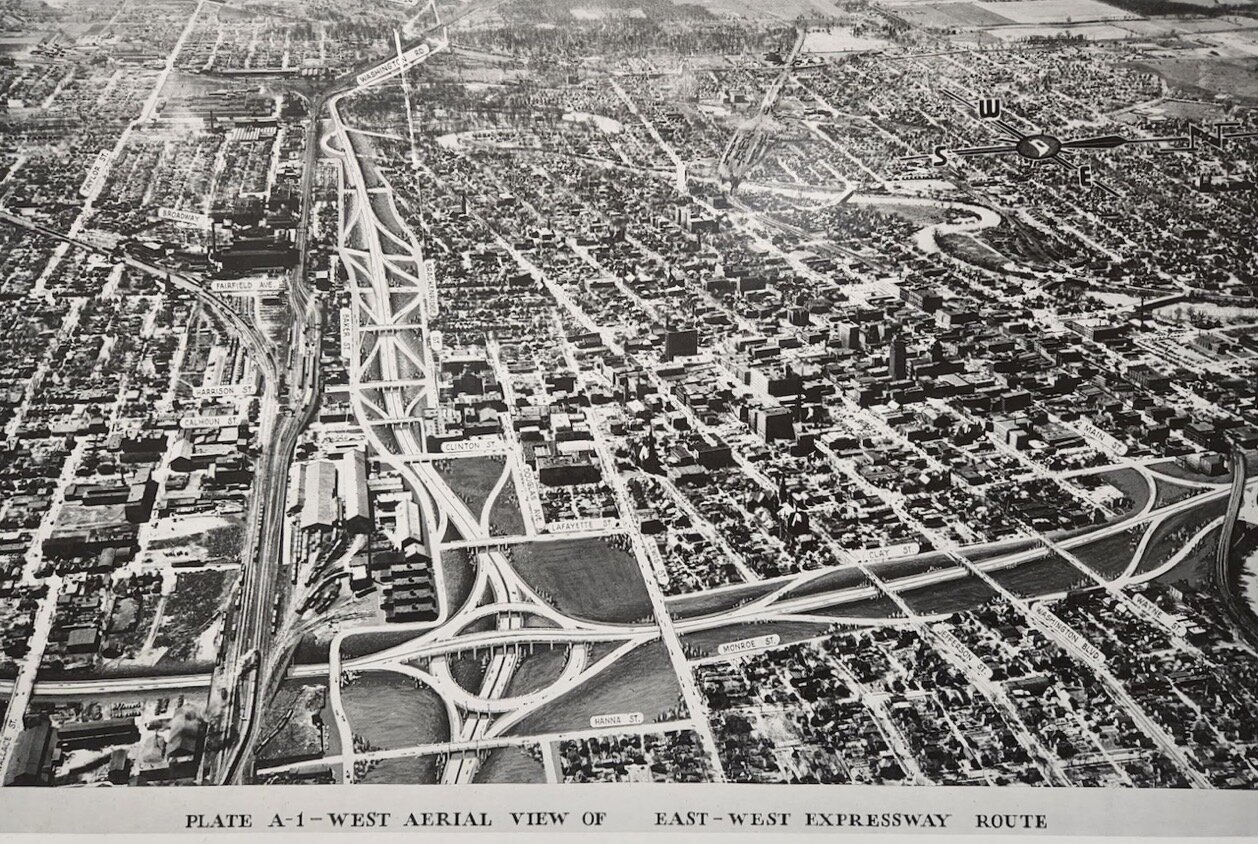
Plate A-1 - West Aerial View of East - West Expressway Route provided by Creager Smith City of Fort Wayne Historian for the proposed expressways through Fort Wayne, which never came to fruition from The urban expressway not taken: Exploring the history and future of Fort Wayne’s roadway system by Joshua Schipper posted March 30, 2022 on Input Fort Wayne. Shared March 30, 2022 on True Fort Wayne Indiana History on Facebook
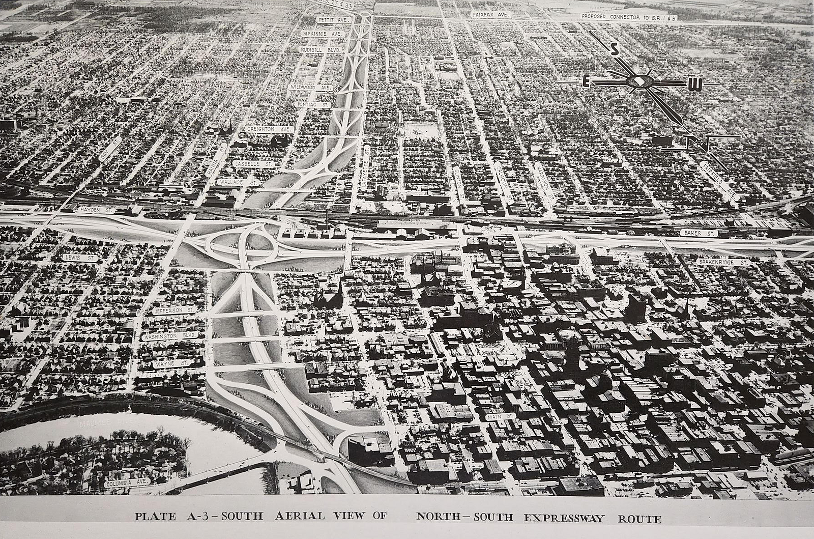 Plate A-3 - South Aerial View of North - South Expressway Route provided by Creager Smith City of Fort Wayne Historian for the proposed expressways through Fort Wayne, which never came to fruition.
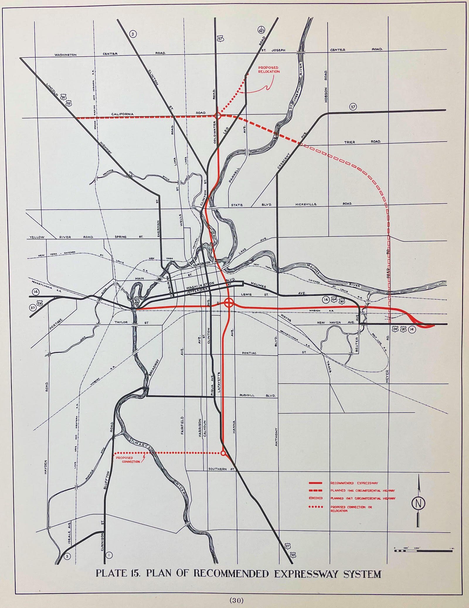
Plate 15. 1946 State Highway Commission plan shows the proposed path of both expressways. It shows the path of a northern bypass, which became Coliseum Boulevard. This proposal routed the northern bypass along Reed Road.
Discussed July 17, 2022 in Great Memories and History of Fort Wayne Private Facebook Group.
Photos of Plates A-2 and A-4 from the lobby at INDOT posted March 25, 2024 on True Fort Wayne Indiana History on Facebook.
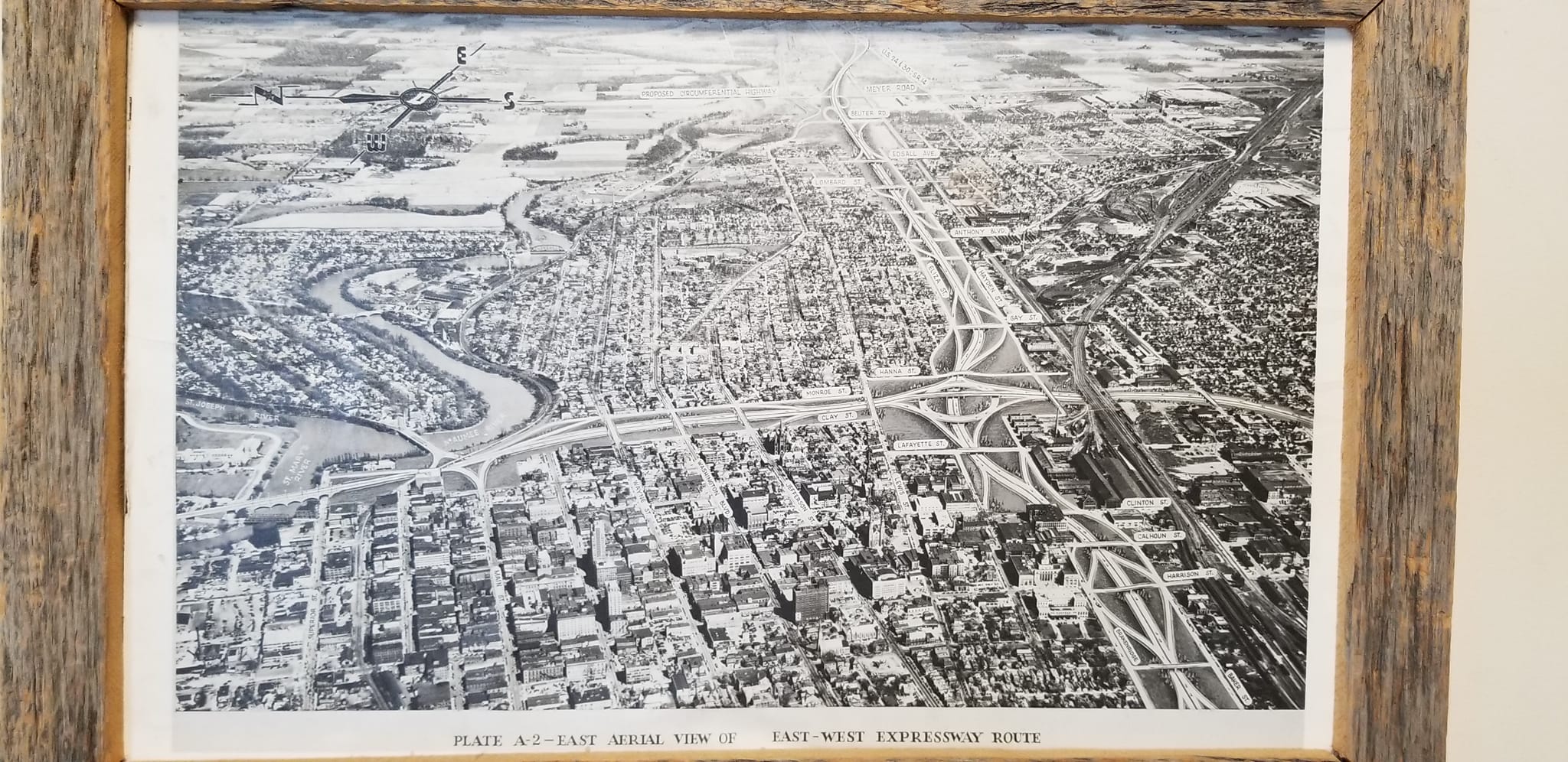
Plate A-2 - East Aerial View of East - West Expressway Route
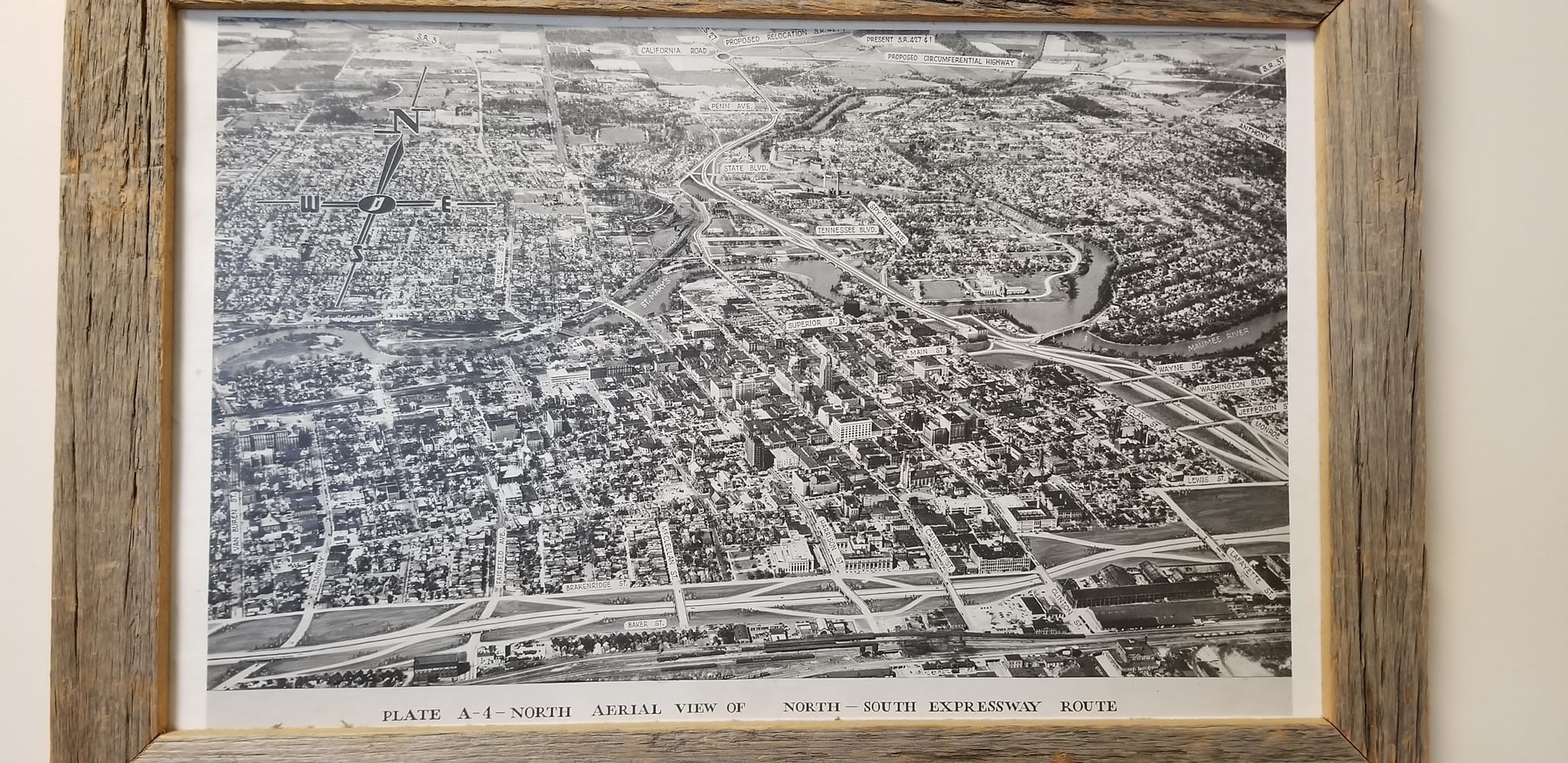
Plate A-4 - North Aerial View of North - South Expressway Route