The Allen INGenWeb Project started in 1996 as a part of the 92 county INGenWeb Project of the 50 state USGenWeb Project all volunteer project to provide Free online Allen County, Indiana genealogy research material.
Our site is an eclectic collection of information related to Fort Wayne and Allen County, Indiana while our hosting site ACGSI.org has 1,000's of pages of name indexes and digital images of Allen County, Indiana public records created by volunteers. Use the Search box at the top of each page to search every pages on our web sites. There are many more pages of information on each of the major page catagory links on the top of each page while social media links are on the bottom of each page.
What's New!
Many new items are announced on the Allen County Genealogical Society of Indiana Facebook page. New "stuff" and corrections are added as time permits from various online sources to the appropriate pages. Check back once in a while or use the search box on any page to see what is new as lots of good "stuff" are waiting for time to add to the site!
Census
The 1950 Census was released April 1, 2022. The National Archives is the official website with a dedicated website indexed and searchable by name and location with a tool available to offer corrections to transcription errors. Allen County Genealogical Society of Indiana has an everyname 1950 Census index for Allen County. Read more on our 1950 Census page.
Biographies and genealogies, some in online books are found on our pages, for people born, lived, or died in Allen County as well as videos from various sources of local people, historical places and local events.
Over 33,000 marriages, 19,000 deaths, 15,000 funeral cards, 4,000 deed citations, census, cemetery, church, divorce, funeral home, newspaper abstracts, school records and more are on the ACGSI Records page.
Timeline pages chronologically list historical events including city directories and online books, links to census microfilm, people pages and more for writing interesting family stories as well as dates and facts to add to your family trees and charts.
Add Your Information
Contact Allen INGenWeb to add names, photos and documents from your family research, historical books, and newspaper articles. Tell us when you find blogs and other Allen County, Indiana related stories and web sites we should add links to or know about!
December 11, 1816 the 4th President of the United States James Madison admitted Indiana as the 19th state of the union. Back then, mountain lions still roamed our thick forests and elk grazed our prairies. The majestic bison, so legendary among both Native Americans and European settlers, already was nearly gone, but a few still roamed Indiana's western edge creating a buffalo trace to the Ohio River. The state population was 65,000, about equal modern Terre Haute with the capital in Corydon moved from Vincennes in 1813. Copied from Celebrating Indiana's rich history by Lee Hamilton and Becky Skillman published September 13, 2015 on BrazilTimes.com.
Born in Ashes: Indiana's Origins - Short Documentary about Indiana's Role in early U.S. History May 2, 2023 kennythenotsogreat on YouTube
While Indiana might not be the most well-known state today, it has played an integral role in the histories of both the (then) nascent United States and the various Native tribes that inhabited the region. What was referred to as the Northwestern Territory (Modern-day Midwestern U.S.) during the late 18th and early 19th century, would become the battleground of two major wars and Indiana would see a major part of those conflicts. Not only were there notable battles, but also exceptional people that took part on both sides of the conflict. From the Northwest Indian War to the War of 1812, Indiana's eventual statehood stemmed from these two conflicts, that finally paved the way for the United States to fully settle the Northwestern Territory. The Miami tribe, as well as other tribes such as the Shawnee, Lenape, Odawa, etc., would be either coerced or militarily forced to cede much of what used to be their lands and eventually be forced to move western across the Mississippi river. Find out in this short documentary about how all of this unfolded.
This production was possible due to the combined efforts of various organizations, all who were passionate about history and Indiana's history. We hope you find this video informative and enjoyable, as history is ever-changing, and the way we remember it shifts as well.
Title card: 0:00 Northwest Indian War: 0:09 William Wells: 6:10 Siege of Fort Wayne: 11:50 Credits, Sources, and Images Used: 17:18
The landscape that became Indiana once was one large natural area with its present boundary unrecognized, uncharted. Within the bounds of present-day Indiana, and stretching from the Ohio River to Lake Michigan, and from the Whitewater River to the Wabash lay more than 36,000 square miles of the finest forests and prairies, swamps and marshes, barrens and savannas, glades and cliffsides, bogs and fens, seeps and springs, and lakes and streams to be found anywhere in the heartland of North America. This paragraph is copied from an essay called Perspective: The Indiana that Was by Marion T. Jackson published in the book The Natural Heritage of Indiana, copyright 1997, Indiana University Press and printed on the website The Inspiration for the Natural Heritage of Indiana Project. Chapter 46. The Wave of Settlement by George R. Parker starting on page 369 discusses Indiana: Land of Indians and early interactions with the pioneers as they forever changed the native landscape with quotes from early histories and a couple of simple maps with settlement dates. See Dr. Marion Jackson - Trees video on YouTube.
THE NATURAL HERITAGE OF INDIANA The Indiana That Was Special | 57m 9s Video has closed captioning. From ancient seas and coral reefs, to Ice-Age glaciation, the first program will explore the massive changes in Indiana's landscape, as well as the plants and animals that developed over these periods. Just 250 years ago, the area was vastly different than the land we know today. Aired: 11/18/07 on PBS.org.
The Natural Heritage of IndianaFrom glaciers to two-story homes, this series documents Indiana's changing landscape. This four-part series documents Indiana's changing landscape from the ancient seas and coral reefs to the farms and suburban homes that now make up the Hoosier image. Highlights include ecosystems around the Ohio River and Lake Michigan, and the Monarch butterfly migration from Mexico. Four videos at PBS.org from WFYI Indianapolis PBS.
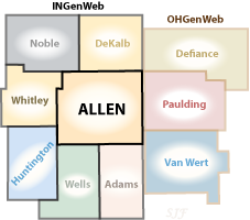
Allen County is located in northeast Indiana with 660 square miles of land making it the largest of 92 Indiana counties. Allen County was created on December 17, 1823, from Delaware and Randolph counties then established April 1, 1824. See our 1824-2024 Allen County Bicentennial page. The county is named for
Colonel John Allen, born in
Rockbridge County, Virginia, an attorney and Kentucky state senator who was killed in the War of 1812 at the
Battle of the River Raisin January 22, 1813 in Monroe County, Michigan. Although the Americans lost the battle at Raisin River, it stopped the British from going to the aid of the Potawatomi Indians who were then attacking Fort Wayne. For his valor in the battle and saving Fort Wayne, Allen County was named for him. Copied from History is in session Courthouse,occupants get book treatment published May 12, 2019 in The Journal Gazette newspaper. Counties in Kentucky and Ohio are also named in his honor. Allen County Launches New Logo and Seal on May 2, 2022 on allencounty.us/
In 2016, Indiana's largest county, Allen County boasts the third largest population and second most number of farms in the state. Roughly 64 percent of its 420,682 acres are in agriculture; producing commodities including corn, soybeans, hay, livestock, poultry, eggs, horses, wheat, oats, and a variety of fruits and vegetables. From A Fun Fact Friday posted July 10, 2015 by the Allen County Extension Service on Facebook. See also November 11, 2016 Fun Fact. Allen County Insight January 2015 shows Allen County ranks 10th in agricultural production. We are also in the top 10 percent of all counties nationwide for grain production and also in the top 2 percent of counties in the country for horse, mule and pony ownership. Our Amish population and the large physical size of the county explain how we can have both high urban population and farm ownership. Copied from County's job gains rival those of '90s, researchers report by Dave Gong published February 14, 2015 in the The Journal Gazette newspaper now on the Internet Archive Wayback Machine. In 2021, Allen County's population increased by 2,716 residents, or 0.7% – more than double the state's rate of 0.3% and five times the 0.12% national rate. The county's population now stands at 388,608, up from 385,892 in 2020. In 2010, the county had 355,939 people. Copied from: County sees 'remarkable' growth surge Population outpacing state, nation by Rosa Salter Rodriquez published March 26, 2022 in The Journal Gazette newspaper. More information is found at Allen County posts fifth straight year of positive domestic migration posted on March 25, 2022 on Greater Fort Wayne Inc.
According to the 2022 population estimates released today by the United States Census Bureau, the city of Fort Wayne, as measured by population within the city limits, is America’s 83rd largest city with a population of 267,927. The annual growth of what remains Indiana’s second largest city was 1,555 people and a 0.6% increase from 2021. Fort Wayne moved up a spot in the largest-city rankings from 84th place in 2021.
Fort Wayne, in 2016, the 100th largest city in the United States from City-data.com, was established in 1794 as a fort named for Army General "Mad" Anthony Wayne a veteran of the Revolutionary War who died in 1796. Fort Wayne was chosen as the county seat in May 1824.
QuickFacts for Allen County, Indiana; Fort Wayne city, Indiana; United States from the United States Census Bureau estimates 265,974 people were living in Fort Wayne as of Juy 1, 2021. The city of Fort Wayne population in 2021 was estimated at 264,169 when Fort Wayne grew by 0.8%, making it the 203rd fastest growing city out of the 797 nationwide with populations of 50,000 or more. Copied from City sees 0.8% population growth Expert cautions against seeing trend in small number by Maya Wilkins published May 28, 2022 in The Journal Gazette newspaper.
Fort Wayne settlement started as the Miami Indian village Kekionga on the banks of three rivers which is a common phrase used in the greater Fort Wayne area. The Maumee River flows northeast from Fort Wayne to Lake Erie through Toledo, Ohio after forming from the confluence of the St. Joseph River flowing south from Michigan through Indiana and northwest Ohio and the St. Mary's River flowing northwest from western Ohio. Large swampy areas surrounded early Fort Wayne into northwest Ohio and were eventually drained to provide fertile farm land. The Little River Wetlands Project is a restored wetlands in the portage area on the southwest side of the city. The former Great Black Swamp east into northwest Ohio was also drained and is now flat fertile farm land. The three rivers are the reason Fort Wayne is here and Riverfront Fort Wayne is a multi-million dollar 21st century river development project designed to highlight the three rivers in downtown Fort Wayne. Downtown Fort Wayne is in St. Joe River watershed, which is part of Maumee River watershed, which is part of Lake Erie watershed, which is part of the Great Lakes watershed. That means rainwater that falls from a downtown building roof could eventually end up in Lake Erie. Copied from an October 1, 2018 Tweet by RiverFront Fort Wayne. It also means we might find interesting background information in histories of those watersheds.
Fort Wayne is on the St. Lawrence River Continental Divide separating the Great Lakes Basin from the rest of the Atlantic Ocean watershed. It is known as the Little River Valley. Summit City became a common nickname during the Wabash and Erie Canal era since it was a high point on the canal. The canal ground breaking was in 1832 and completed from Fort Wayne to Huntington County July 3, 1835. The canal lead to the bankruptcy of the state of Indiana and was replaced a couple of decades later by the growth of the railroads. Hungarian cartographer and GIS analyst Robert Szucs developed a colorful new map that easily shows the contrast between the Mississippi River basin in pink and Fort Wayne's three rivers in the green section of the U.S. river basins. You can see it on his Grasshopper Geography etsy page and zoom in on the United States map.
Fort Wayne was incorporated as a city in 1840 and as Indiana's second largest city historically serves as a transportation and communication center for our region.
I am Stan Follis the county coordinator since April 2009. The About Allen INGewWeb page discusses our history back to 1996. I can add your family research, data, photos, family trees, transcriptions of historical books, cemetery photos, house photos and more to our pages. Contact Allen INGenWeb to volunteer and/or provide material and suggestions for our site.
Only a small percentage of available documents are found online compared to all the papers, manuscripts, periodicals, and books available in private collections, public and research libraries, courthouses, and archives.
Public Domain
Most publications before 1927 are in the public domain so are copyright free for any use. Starting January 1, 2019 the public domain date added one more year each year on January 1 to the public domain time frame. See Center for the Study of the Public Domain by Duke Law School on law.duke.edu and our Copyright page for more information.
If you would like to contribute your family histories, documents, biographies, bible records, maps, photos, help index online ebooks, or found useful links to other Allen County, Indiana web sites Contact Allen INGenWeb.