1913 - Passing of Fort Wayne From Military Garrison to the White Man's Settlement Fort Wayne Weekly Journal-Gazette, Fort Wayne, Indiana, Friday, December 26, 1913, Page 3.
The Last Commandant; His Career In The West And His Religious Characteristics
When in the early spring of 1819, during the month of April, the military garrison at Fort Wayne was abandoned and the fort evacuated, the commandant was Major Josiah N. Vose. He had been here for two years, having in 1817 succeeded Major Whistler.
The local histories print his name as J. H. Voss. In fact, I have learned, through a letter one who was intimately acquainted with him in the southwest, local history was wrong. His name was Vose, and the middle Initial was "N' instead of "H," and after leaving was promoted to the rank of colonel.
While stationed at the garrison here and for some years previous, Major Vose was an officer of the Fifth United States infantry. After leaving Fort Wayne he was stationed at one of the forts in the southwest for eight years, from-1833 to 1840, being comandant at Fort Towson in Choctaw country.
His death occurred at New Orleans in 1845, while he was yet in the service of the United States as an army officer. Most of his life was spent as a soldier. He was with Gen. Harrison's army in the battle of Tippecanoe and later spent his life guarding with the soldiers in his commands, the forts on frontier settlements.
One of his sons, Gardiner Vose, became a minister of and was for a number of years a professor of rhetoric in Amherst college. A daughtor the wife of Lleutenant Barnwell, the United States army, and for years resided in North CaroIna.
Divine Worship at Fort.
Major Vose was the only commandant at the old fort here at Fort Wayne to have religious services regularly on Sunday with the soldiers and men in the military garrison and, so it is said the only commandant who made a public profession of christianity. This statement is made on the authority of Col. John Johnson, who was connected with the government Indian department and who for twelve years made his headquarters here with his family, part of the period being during the commandery of Major Vose. In a letter written in November of 1859, to one of the members of the First Presbyterian church of Fort Wayne, Col. Johnson had the following to say of Major Vose and of religious service at the Fort Wayne military garrison:
"I was appointed to the Indian department in 1800, and stationed at Fort Wayne, that being my headquarters. During the period of my service, which continued until after Col. Vose's there was not a protestant clergyman of any denomination who held divine services post there. The only officer of the army, within my knowledge, who publicly professed christianity was Col. Vose.
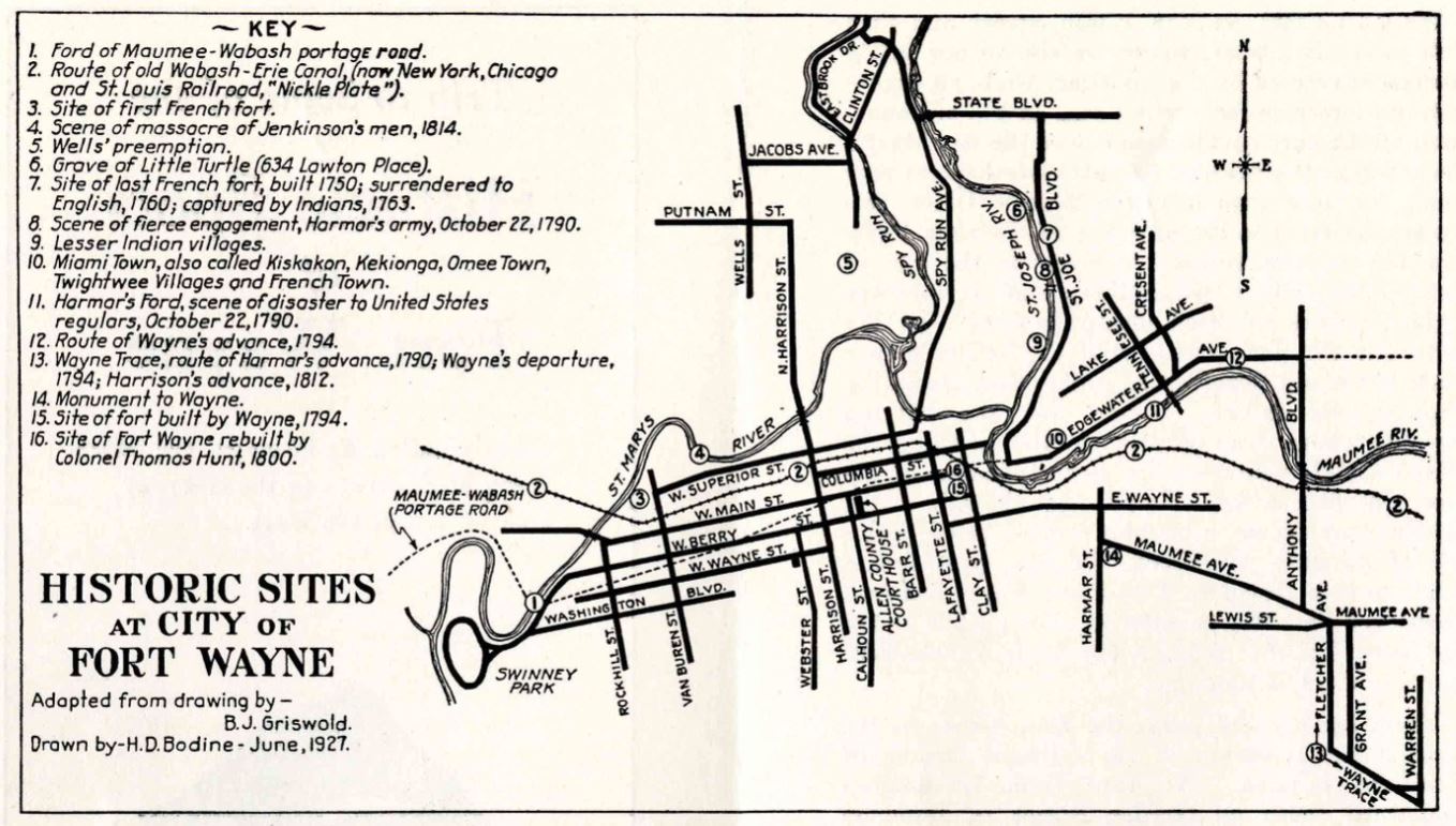
Five forts were built all located within a square mile of the center of the current city of Fort Wayne. The current fort is a replica of the 1815 "Whistler's Fort." The reason for the first fort was to protect the fur trade.
December 30, 2021 post by the Military History of Fort Wayne on Facebook:
THE LOCATION OF THE FORTS.
"The exact spot, or, rather the very bounds of the fort grounds are not, at this distant period, to be ascertained; but enough is certainly known to advise the interested that the ground selected for this [Wayne's] fort is that which is designated on the city of Fort Wayne as lots 11, 12 and 13, within Taber's addition, laid out 15th April, 1835, being at the northwest corner of Clay and Berry streets, near where Clay street crosses the canal [Nickel Plate railroad tracks] at the Maumee bridge [then at Main street] just below the junction of the St. Joseph and St. Mary's. [Lot 11 is now occupied by the new building of the Western Newspaper Union, erected in 1916. Calvin K. Rieman states that when his father purchased this lot in the seventies and commenced an excavation on the property, he dug out the fragment of a pole, set deep in the ground, which the late Franklin P. Randall believed to be the flagpole of Wayne's original fort. Mr. Dawson, writing in 1872, says that this stump of a pole was doubtless the remnant of one of the liberty poles erected by the whigs in honor of General Harrison in the summer of 1840, when "this place, as others in the west, ran up so many poles that the traveler approaching the town was reminded of the spars of shipping in some harbor."] This [Wayne's] fort was of log construction, well located but not very safe. The location commanded the Maumee for half a mile below the junction, and the mouth of the St. Joseph and the St. Mary's. It was small, and, not serving the purpose, was torn down about 1804 [really in 1800] and a new one built on what is now lot 40, in the addition named above [Taber's] by Colonel [Thomas] Hunt. [Lot 40 is almost identical with Old Fort park. It seems very probable that the troops occupied the original fort during the period of construction of the second fort, so there were two American forts standing at the same time, [separated by perhaps three hundred feet of space.] This was taken down in 1817 [really in 1815-1816] by Major Whistler and rebuilt in a most substantial manner. From the best information, it seems to have enclosed an area about 150 fee square in pickets ten feet high, and set in the ground, with a block house at the Southeast and Northwest corners, two stories high. The second floor projected and formed a bastion in each where the guns were rigged; that on the southeast commanding the south and east sides of the fort, and that on the northwest the north and west sides. The officers' quarters, commissary department and other buildings located in the different sides, formed a part of the walls, and in the center stood the different sides, formed a part of the walls, and in the center stood the liberty pole on which was placed a metal American eagle, and over that floated the Stars and Stripes of the United States.
"The plaza, in the enclosure was smooth and gravelly. The roofs of the houses all declined within the enclosure after the shed fashion, and to prevent the enemy from setting it on fire, and, if fired, to protect the men in putting it out; and the water which fell was led in nicely made wooden troughs, just below the surface of the ground, to the flagstaff, and from thence led by a sluiceway to the Maumee.
"It is thought it left out a small portion of the old ground [that is, when Major Whistler rebuilt the fort he did not include all of the ground covered by the fort as built by Colonel Hunt], for it is definitely known that the southwest corner of the new fort was exactly at the corner of lot 40, the pickets running south of east, toward John Brown's blacksmith shop, and near where the shop now stands [1858], and where was one of the forts [blockhouses]. The east side ran to a point on the north bank of the canal, then west to the second fort and then [south] to the place of beginning.
"The stone curbing of the old well may yet be seen [1858] in the edge of the south bank of the canal and near the northwest corner of the fort. [In June, 1847, the Fort Wayne city council paid Dennis Dumean $1.50 for "filling up well at old fort"]. The canal cut off the north end of the fort, by which the pickets were removed, and this ancient relic invaded about 1833.
"Commencing at the north and at the upper side of the fort was a fine wagon track that ran obliquely down the bank, landing near lots 1, 2, 3, 4, 5, and 6, Taber's addition, and just below and about the south end of the present bridge over the St. Mary's at that place. [The bridge, at that time, 1858. crossed the St. Mary's at Lafayette street. The lots mentioned compose the unoccupied south bank of the St. Mary's running east from the Spy Run bridge. This was known for many years as the pirogue landing.]
"The fort itself was one of the most substantially built in the west. Attached to it was the commanding officers' garden of about one acre, which was on the west, including what are now lots 35, 36, 37 and 38, Taber's addition. * * * The company's garden extended to the west of that of the commanding officer, and ended about where the Hedekin house now is [Barr street], embracing, perhaps, lots 30, 31, 32, 33, 34, 26, 27, 28 and 29, County addition, and was most highly cultivated.
"The road ran about where the canal does now [right-of-way of the Nickel Plate railroad], from what is now the northeast corner of Columbia and Barr streets, eastward to the fort.
"To the south of the fort, where F. P. Randall, Esq., now lives [northwest corner of Lafayette and Berry streets), lots 35, 26 and 37, County addition, and lots 11, 12 and 13, Taber's addition, was a graveyard, where were buried many persons—officers, citizens and soldiers, who had theretofore died. [It will be observed that this graveyard included the area occupied by Wayne's fort.] * * * Another place of burial was that now occupied by the Times building [1858] and block contiguous—northeast corner of Columbia and Clinton streets, where many whites, children and Indians were from time to time buried—the bones of whom have been lifted as workmen have dug for foundations for building."
A later observation by the same writer is as follows:
"The timbers [for the rebuilt fort] were cut by the troops on the grounds now [1858] held and occupied by H. B. Taylor, James Embry, Samuel Hanna, and that between here and there on the east of town. It was hauled by the aid of oxen, ropes used instead of chains, and raised by the troops into officers' quarters, commissary departments, blockhouses, etc. The pickets were 12½ feet long and were put in sets of six, with a cross-piece two feet from the top, let in and spiked, and a trench dug 2½ feet deep, into which they were raised. A part of the old was taken down at a time and replaced by the new. It was in this year [1815] that a small log house was built in what is now Barr street, near the corner of that and Columbia, and was located within range of the fort, that it might be razed if it were attacked by the enemy. This primitive building was afterward set out of the street and stood for a long time as a part of Washington hall [Ewing's Tavern], facing Barr street."
The late George W. Brackenridge thus described the appearance of the fort in 1830:
"Timbers of the old fort were standing in 1830. They were about a foot square, eight or ten feet high, pointed at the top. The stump of the flagpole was also in front of the two blockhouses which occupied the high ground at the east end of Main street, north side—both built of hewed logs. These buildings were two stories high, consisting of two large rooms below, same above, both lengthwise north and south. The one farthest from the street was taken down when the canal was dug. The other stood many years afterward, occupied by tenants. A blockhouse for storing arms and ammunition with an all-round over-jet second story, stood about seventy-five feet west of the two aforementioned."
Writing of 1838, John W. Dawson says: [ Page 235 Pictorial History ]
"A common road ran down along the canal and across the old fort ground, between the old well and the only building of the fort then standing. This building stood on the vacant ground [now Old Fort Park]; it was two-story, and had been changed from a shed to a conical roof. It had been used originally for officers' quarters. A broken pole stood in the center of the parade ground, on which the Federal flag had been originally hoisted. The pickets which had enclosed the ground had nearly all been removed, yet the line where they stood was marked. A post at the gateway at the southwest corner of the stockade on the alley between Berry and Wayne street, was standing. These pickets and the logs which had composed the other buildings within the pickets, had all been removed by the people for building purposes."
The last of the buildings was torn down in 1852. Early in that year enough of the original stockades and buildings remained to arouse a vigorous but ineffectual protest against their final destruction. In that year Dr. G. W. Bowen, writing in the Laurel Wreath, a local publication, gave utterance to his sentiments in verse. The title of the poem was, "Spare Wayne's Fort." The opening stanza follows:
Why tear it down and spare it not?
Are other days so soon forgot?
Are other scenes no more to be
Brought back to sweet, blessed memory?
And must those walls that served so well
To shield at night from savage foe
That daring band, be leveled low?
The silent truth forbid to tell!
Source:
The pictorial history of Fort Wayne, Indiana : a review of two centuries of occupation of the region about the head of the Maumee River Volume 1 by Griswold, B. J. (Bert Joseph), 1873-1927; Taylor, Samuel R., Mrs, Publication date: 1917 on Archive.org