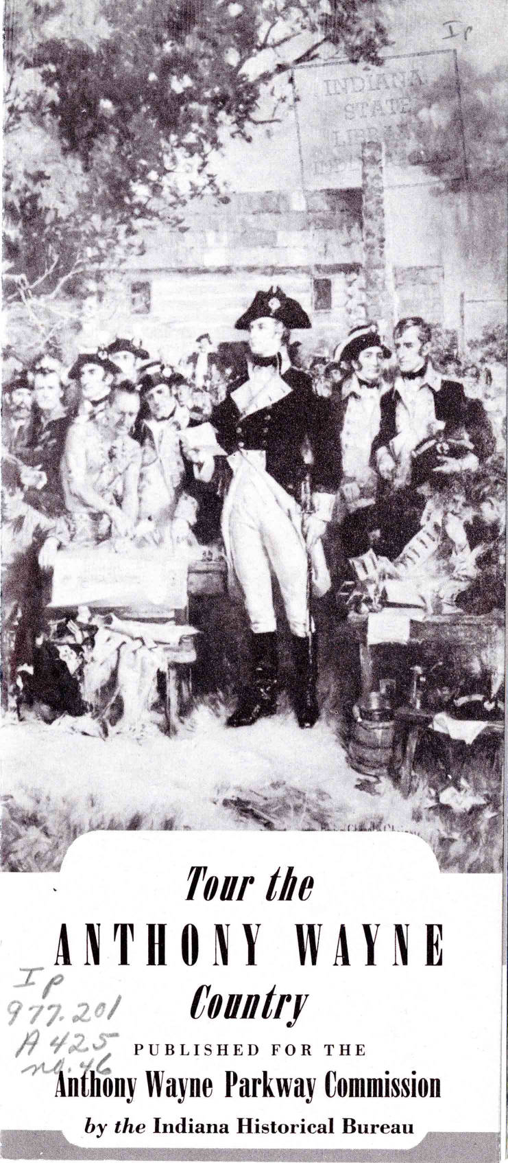
1954 Tour the Anthony Wayne County - This is a pamphlet promoting the Anthony Wayne Parkway. It includes information about "the men who opened Northeast Indiana." It includes a map of the "old trails and modern highways" as well as information about the Parkway Program. in the Indiana State Library Digital Collection.
X marks the spot Publication date 1964 on Archive.org includes photos of the plaques and markers placed in the city and county by The Alen County-Fort Wayne Historical Society from 1959 thru 1963.
Did you know that there is a walking trail tracing Fort Wayne’s history free and open to the public all year long? It follows blue, red and white street signs over four separate routes and is complete with a self-guided tour map available from ARCH or the History Center. Featuring historical markers that describe the significant sites in the region, this unique walking tour is a 1994 Bicentennial Celebration lasting legacy gift to the citizens of northeastern Indiana. All in all there are four trails: The Central Downtown, West Central, South Central and the Kekionga or Lakeside neighborhood taking in the rich heritage of our region. The markers that describe the various stops are oriented for pedestrian viewing, so walking the Trail may be a better plan than trying to sightsee from a car window.Copied from the heading Side Bar near the bottom of The Hall Community Arts Center by Tom Castaldi published May 2, 2013 in the History Center Notes & Queries blog. Originally printed in Fort Wayne Magazine, “Along the Heritage Trail with Tom Castaldi” – November/December 2004, No. 8 p. 53.
☀️ Walking weather is finally here—and we’ve got the perfect way to enjoy it! Take a stroll through the heart of the...
Walking weather is finally here—and we’ve got the perfect way to enjoy it! Take a stroll through the heart of the city with Visit Fort Wayne#DTFW Walking Tour!
This self-guided tour is packed with local landmarks, museums, parks, and pit stops to grab a bite or a drink. Whether you’re planning a family outing or a day date, it’s a fun way to get out and explore!
Start your adventure here Fort Wayne Walking Tour Print a map of the walking tour to take with you.
ARCH ( Architecture and Community Heritage) Central Downtown Trail has 19 stops at historical location markers with the information on a web page for each stop.
The National Register of Historic Places listed the Brookview-Irvington Park Historic District in 2011. It features homes that include colonial revival, Tudor revival and neoclassical as well as bungalow-craftsman, prairie and a Lustron. It also includes commercial stores. The signs that have been put up tell a bit about the history of the neighborhood, from its creation by Wildwood Builders, including female architect Joel Ninde, the design by Boston-based landscape architect Arthur Shurcliff, the Conservation Civilian Corps projects and its parks with a connection to Centlivre Brewery. Two signs are across from each other on State, one near the crosswalk and access to Oakridge Road, the other by the entrance to the walking trail. A third is on Westbrook Drive at the pedestrian bridge. The fourth is on the west side of Westbrook near Grove Street by the entrance to the Centlivre housing addition. Copied from March 4 - Brookview-Irvington Park Historic District gets history signs by Lisa Esquivel Long posted Mar 4, 2021 on Greater Fort Wayne Business Weekly posted March 5, 2021 on Fort Wayne Community Memories on Facebook.
at least eight other monuments are slated for improvements, about one a year, starting with the statue of the city's first Park Board president, David Foster, which probably should be moved but won't. It has stood in East Swinney Park since 1922, and as I noted last year, the "mistake" may have been intentional. Legend has it that, before his death in 1875, Col.Thomas Swinney donated the land for the park that bears his name on the condition that ownership would not change until after the death of his two daughters, who lived nearby. Foster supposedly wanted the land sooner, and suggested the last surviving daughter move out so he could develop the park. When she refused, the statue of Foster was put on a tall pedestal so he could glare at the home that still stands today as the headquarters of the Settlers historic group. That story may or may not be true, but there's little doubt the restoration of Wayne's statue -- which generated much controversy after Mayor Tom Henry suggested it be moved to the Allen County Courthouse -- turned out to be a blessing for the city's other monuments as well. Copied from City's history is in for a monumental -- and well-deserved -- facelift by Kevin Leininger published November 14, 2015 in
The News-Sentinel newspaper.
Indiana Roadside Markerson their YouTube channel launched April 15, 2021 by Michael L. Harris of Syracuse, Indiana. He started the project about three years earlier and has the photography complete on the first year's batch of 26 videos. He is researching the stories and finding pictures and articles to fill out the information on the more than 600 official roadside markers throughout the state. Some of the Allen County topics include Fort Miamis, Camp Allen, the site of Hardin's Defeat by Chief Little Turtle, the home of television inventor Philo Farnsworth, the Wabash and Erie Canal groundbreaking site and Gronauer Lock No. 2. The videos relevant to Allen County will be found on Allen INGenWeb as he publishes them. His project was discussed in Syracuse man making mark State markers documented in YouTube show by Blake Sebring published 2021 in The Journal Gazette newspaper.
Who Put That There?There’s a great little book entitled “Who Put That There” that can serve as a guide for exploring Fort Wayne’s history. The book was written by students at St. Jude Catholic School in 1998 with an Historic Preservation Grant from the Historic Landmarks Foundation of Indiana, the Indiana Humanities Council, and the National Endowment for the Humanities. Posted January 3, 2011 by Nancy McCammon-Hansen
on the History Center Notes & Queries blog.
The perfect storm is brewing in Fort Wayne about whose statue is standing in which park named what. As far as I can understand it, Foster’s statue is in Swinney Park instead of Foster Park, Lawton’s statue is located in Lakeside Park instead of Lawton Park, Chief Little Turtle is hidden in Headwaters Park, the Civil War memorial is in Lawton Park, Anthony Wayne’s statue is overwhelmed by trees in Freimann Square, and the Memory statue in Memorial Park is of a woman whose head is missing. Copied from Let’s rename the city’s parks so they match the statues that are in them by Nancy Carlson Dodd posted August 16, 2013 in
The News-Sentinel newspaper.
Front Door Fort Wayne has maps showing proposed gateways and existing markers and historic structures.
Marker site needs proof of accuracyalong Carroll Road where it crosses the Eel River northwest of Fort Wayne, there stood a historical marker, calling attention to something called Hardin’s Defeat. June 11, 2013 by
Frank Gray of The Journal Gazette newspaper.
Signs of the "history" timesat least six kinds of local historic signs and markers from groups like the Indiana Historical Society, local Allen County Fort Wayne Historical Society or the Mary Penrose Wayne Chapter of the Daughters of the American Revolution, Parks department, National Register of Historic Places and more April 16, 2013 by Nancy McCammon-Hansen on the History Center Notes & Queries blog.
IHB is now accepting applications for new state markers! A key part of the application process is finding primary sources to support your topic. Throughout the month, we’ll share examples of types of primary sources that might help as you complete your application.
One source that can prove useful in highlighting where a business or residence was located is Sanborn Fire Insurance Maps. These maps were created to provide detailed drawings of the buildings in a city to assess the fire risk for insurance companies. They can also show us how areas developed over time. While working on the Leedy Manufacturing Company marker in Indianapolis in 2021, we used Sanborn maps to confirm the plant’s exact location, see when additions were built, and learn what was housed inside as well as how the different floors were organized. The maps also allowed us to understand what existed in the surrounding neighborhood at the time.
You can access Sanborn maps through the Fire Insurance Maps Online Database while inside the Indiana State Library or search the maps on ISL microfilm. Learn more about Sanborn maps through this Indiana State Library blog post: http://bit.ly/3yivfgv.
The Sanborn map featured below is Indianapolis Sanborn Map #159, 1915, courtesy of the Indianapolis Sanborn Map and Baist Atlas Collection. View the map in full at: http://bit.ly/3kQyk4l.
IHB is now accepting applications for new state markers! A key part of the application process is finding primary sources to support your topic. One of our favorite though often underused sources when researching historical marker topics is city directories.
City directories can inform us where an individual lived or where a business was located in a particular year, can provide information about occupations that individuals had, and can shed light on various institutions that existed in a city, including hospitals, charitable organizations, churches, clubs, libraries, and parks, to name a few! You can search city directories by name through the alphabetical listing, by category in the Miscellaneous Information section, and by street address.
While doing research for the Lt. Col. Joseph H. Ward, M.D. marker in Indianapolis in 2019, we used city directories from 1897 through 1949 to track the location of Ward’s medical practice as it moved from various locations on Indiana Avenue to Boulevard Place. A search of Ward’s name in the alphabetical listing of the 1922 Indianapolis City Directory noted that he was a physician, surgeon, and proprietor of Ward’s Sanitarium, listed the address of the business and noted that it was the same as his home residence, and included the hours the practice was open. The Miscellaneous Information section of the directory also listed Ward’s Sanitarium as one of several Asylums and Hospitals in the city.
The Indiana State Library has a large collection of city directories. You can access information by county here: http://bit.ly/3yJJbA9. Many city directories are also available electronically via Ancestry Library (which can be accessed for free while visiting the State Library) and through the Internet Archive at www.archive.org..
The image below is courtesy of the 1922 Indianapolis City Directory, accessible through archive.org.
It’s National Historic Marker Day! Did you know that we have worked with communities across Indiana to install nearly 750 state historical markers dating back to 1946? Take some time today to learn about the rich history of our state through these markers! You can find the full listing or search by county or category at https://www.in.gov/.../state-historical.../find-a-marker/.
IHB is always looking for volunteers to help survey markers so we know that they’re still standing and what condition they’re in. National Historic Marker Day is also a great opportunity to help clean or repaint markers in your community! Contact cpfeiffer@library.in.gov if you are interested in getting involved!
National Historic Marker Day is scheduled for Friday, April 26th! Consider getting involved in this service-oriented...
National Historic Marker Day is scheduled for Friday, April 26th! Consider getting involved in this service-oriented event by visiting a few of Indiana’s state historical markers – we’ve installed over 750 of them since 1946!
IHB is always accepting photos or updates of our markers to ensure they are still standing and assess their condition. Please send updates to us at ihb@library.in.gov.
Looking to get involved? Volunteer to clean or repaint a marker! Be sure to contact IHB ahead of time if you have a marker in mind or if you want to know which are most in need of refurbishment. After reaching out to us, consider registering through the William G. Pomeroy Foundation too! Registered participants will receive National Historic Marker Day stickers, be acknowledged on the Pomeroy Foundation website, and will be eligible for a special giveaway after submitting photos from your cleaning project.


 Walking weather is finally here—and we’ve got the perfect way to enjoy it! Take a stroll through the heart of the city with Visit Fort Wayne #DTFW Walking Tour!
 Fort Wayne Walking Tour Print a map of the walking tour to take with you.