Active cemeteries still accepting burials usually have an office or sign near an entrance with a contact phone number. Most cemeteries originally had a sexton who kept the records for burials, maintained the cemetery, and lived close by. A local funeral home may know if original burial records exist for inactive cemeteries. Church graveyard records may be with the church if still active or its successor. Rural cemetery burial records are sometimes kept by a longtime local business nearby such as lawn tractor business or barber shop. Large cemeteries may have a dedicated paupers burial area such as at Lindenwood or the Catholic Cemetery often with no visible markers. The office would know if such areas exist. It is likely many were buried in nearby burial grounds without permanent markers.
The Mary Penrose Wayne Chapter NSDAR Allen County Indiana Cemetery Project made cemetery readings in 1932 that may contain information available no where else. In 1982 the Allen County Genealogical Society of Indiana updated the cemetery readings that revealed many tombstones from 1932 were missing. The results were published in Cemetery Township books available on their www.acgsi.org website and at The Genealogy Center at the Allen County Public Library in Fort Wayne, Indiana. The NSDAR starting taking photographs in 2008 of every existing tombstone at over 147 cemeteries in twenty townships over several years and published them on their website stating: "there are over 165,000 photos on this web site. And transcriptions for over 219,000 people." "Member volunteers visited each cemetery and photographed each tombstone. The tombstones were then transcribed exactly as they were written. There is no other information on any person other than what is listed." They have a Master Name Index.
All known Indiana cemeteries have been surveyed by SHAARD Indiana State Historic Architectural and Archaeological Research Database (SHAARD) and whatever information was found sometimes including history, maps, and photos is on their website.
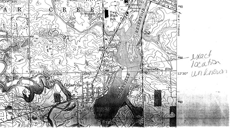
02-22 survey map v.2.pdf has a topographic map pointing to Cedarville and the same 1/18/2008 aerial map image of the Ewing Street and Gerig Road intersection area by the Indiana Geological Survey
02-23 survey form.pdf Cemetery Registry Survey, Leo Road south of Grabill Road, 3/27/02, 1629 occupied spaces, 7 acreas, shed.
Aerial Map showing Leo Memorial New on West (left) side and Leo Cemetery Old on East side top right on Leo Road south of Grabill Road.
Leo Cemetery - Old
14850 Leo Road, southeast corner with Grabill Road in Leo. Street View photo from Google Maps
Earliest date about 1844. Scherer & Maxfield, 14520 State Road 1, south of the old cemetery and across from the New Leo cemetery has the sextant burial records.
Appears to be almost the same shot as the Google Street View.
A comment to the Facebook post says a cemetery on the east side of the St. Joe River was moved to the Leo side when they widened the river in the 1950s. This cemetery is on the west side and Leo now surrounds it.
Google AI July 20, 2026 says the bodies were moved to the New Leo Cemetery on the west side of Leo Road.
Links to the Mary Penrose Wayne Chapter NSDAR Allen County Indiana Cemetery Project photos are on the Cedar Creek Twp page. Not on their Old Leo Cemetery page.
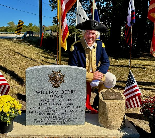
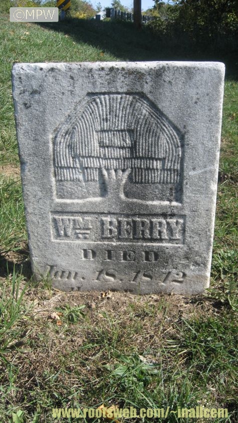
MG Anthony Wayne brought his 3rd US legion through Fort Wayne in 1794 and stopped to pay his respects to fellow soldier William Berry, who fought with him at Yorktown. (Seen today at William Berry’s Grave Marking)
From David Edwin Rousculp:
"It was an honor to speak and pay my respects to William Berry’s new monument, presented by the SAR today at Leo Cemetery, In."
The Anthony Halberstadt Chapter of the SAR, the Mary Penrose Chapter of the DAR and the William Berry Chapter of the CAR...
The Anthony Halberstadt Chapter of the SAR, the Mary Penrose Chapter of the DAR and the William Berry Chapter of the CAR met today (9/18/2025) at Old Leo Cemetery to dedicate a Pomeroy Marker to Rev War Patriot William Berry. We even recruited two CAR members to march in our Color Guard.
West side near 10500 St. Joe Road , 0.1 mile north of Notestine Road. Hard to see when foilage is on the trees and vegetation.November 2015 Street View photo from Google Maps
Earliest date March 28, 1831. No longer used. Out of sight off the road on private property. IN DNR Latitude 41.1817 Longitude 85.0472.
A stone marker for a child named Aaron D. Rinehart, died October 1, 1864, aged 2 months, 5 days, son of Andrew and Mary Rinehart was found in a city backyard. The stone had a carving of a lamb and two little footprints. The story is told in Vandals’ moving of markers hinders cemetery project by Frank Gray April 5, 2012 in The Journal Gazette newspaper article.
East bank of the Saint Joseph River, 0.3 mile south ( or is it north? see below) of Wheelock Road
No longer visible - two tombstones: 1857, 1861. Recorded directions are 0.3 mile south of Wheelock Road, Google map indicates it would be 0.2 mile north of Wheelock Road in order to be along the east bank of St. Joseph River near a large tree. In 2008 the NSDAR could not locate anything to take photos. Allen County Genealogical Society of Indiana1980s reading said the markers were on the St. Joseph River bank beside a very large and old tree. If you know where the two Rhodes tombstones are located please let us know.
Earliest date October 15, 1848. No longer in use. IN DNR Latitude 41.2191 Longitude 85.0192 which is different than Google map labeling it St. Michaels at Latitude 41.238012 Longitude -85.028788.
The name first applied to the congregation was St. Bonifacius, but this has long been changed for "St. Leo's." The church edifice at Leo was built by Fathers Benoit and Faller, in 1856, and the pastoral residence by Father Zumbuelte in 1870. Cemetery grounds were donated in 1863 by Peter Sullivan.
Earliest date October 30, 1873. There is supposed to be a large plaque in the Leo Memorial Cemetery. DAR transcriptions and photos will be included with that cemetery. Google map shows the former location on the east side of Saint Joseph River by Schwartz Road. IN DNR Latitude 41.2203 Longitude 85.0078. Area now looks like the beginning of Riverside Gardens Park with walking trails.
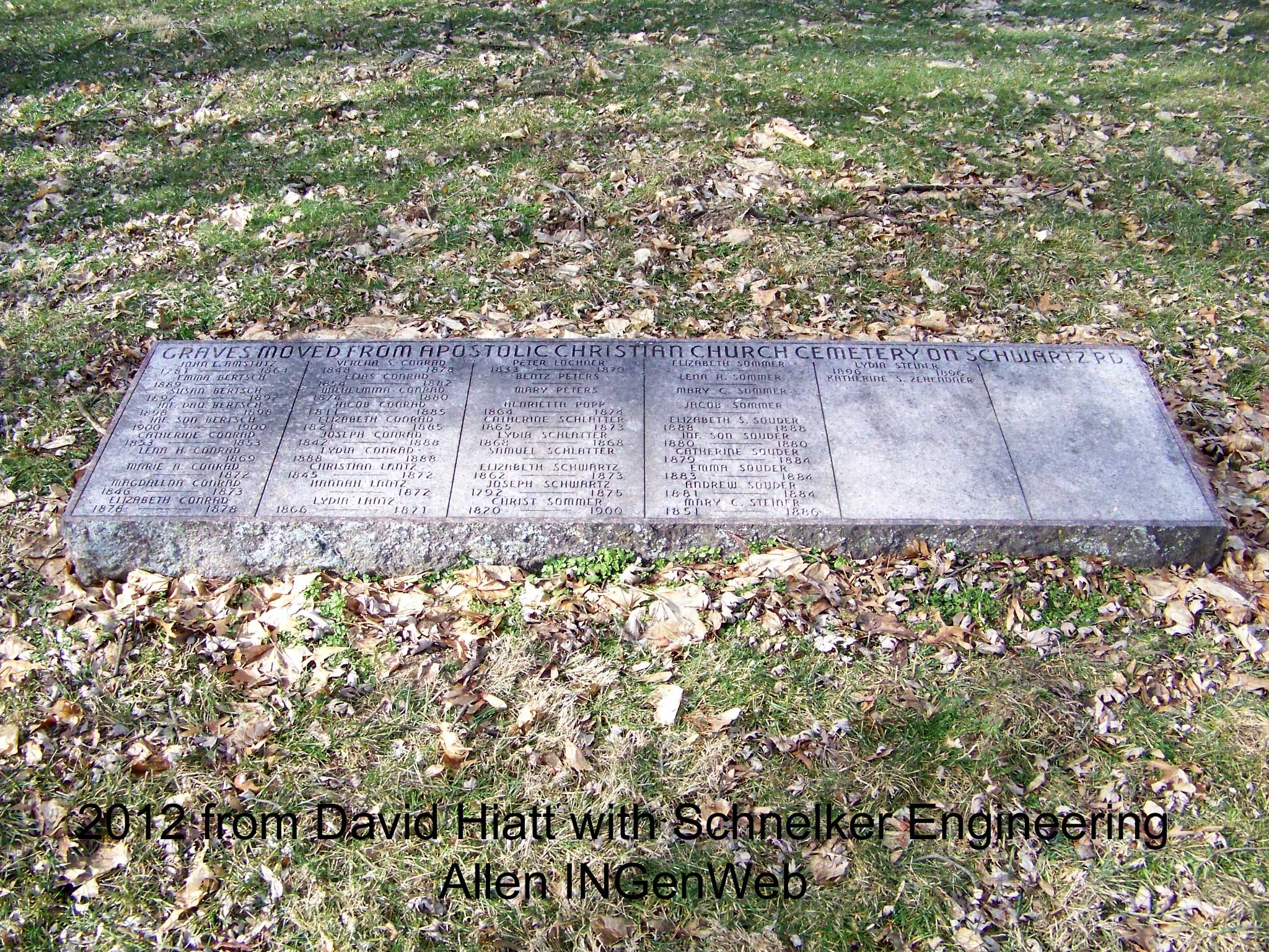
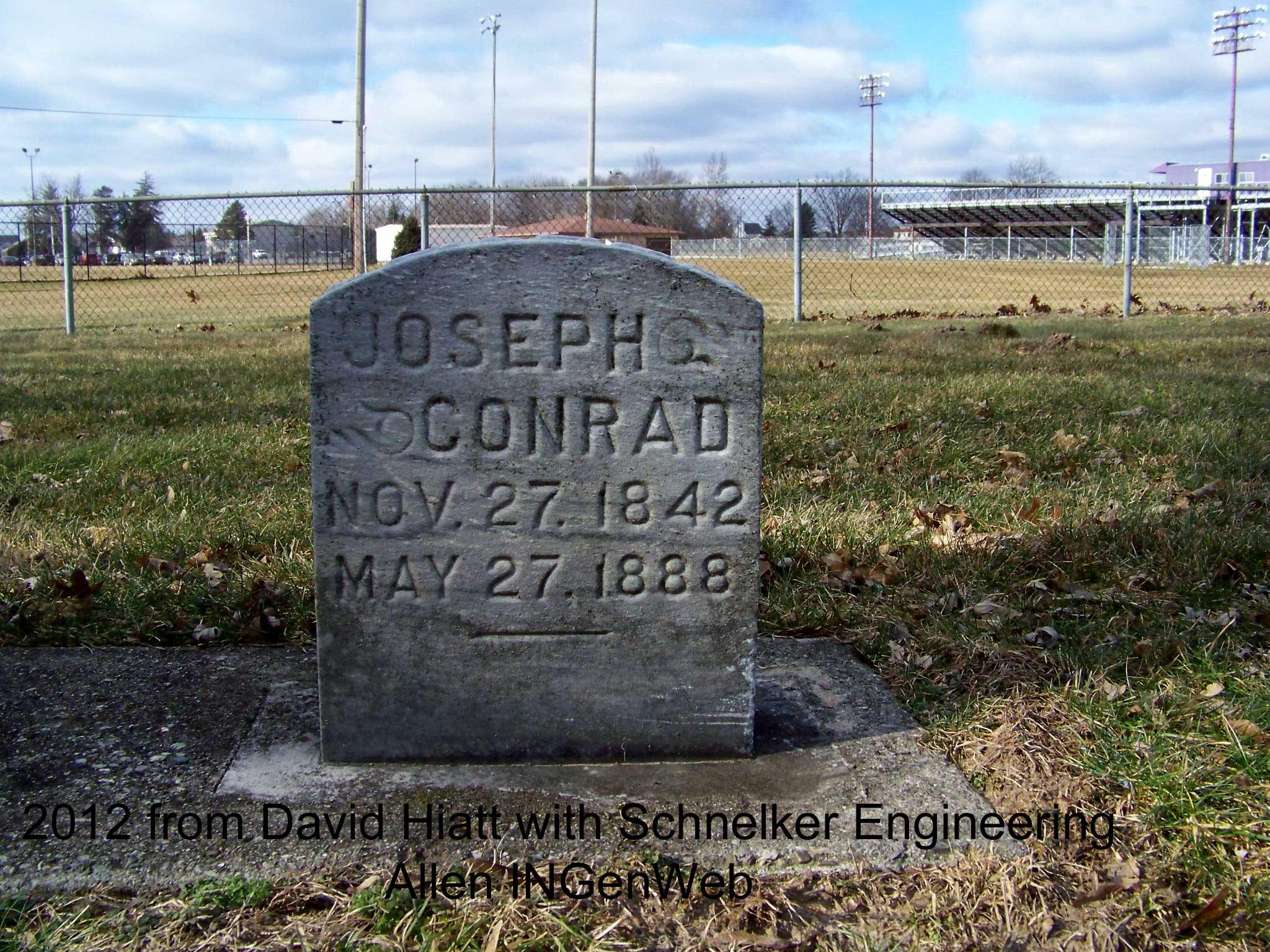
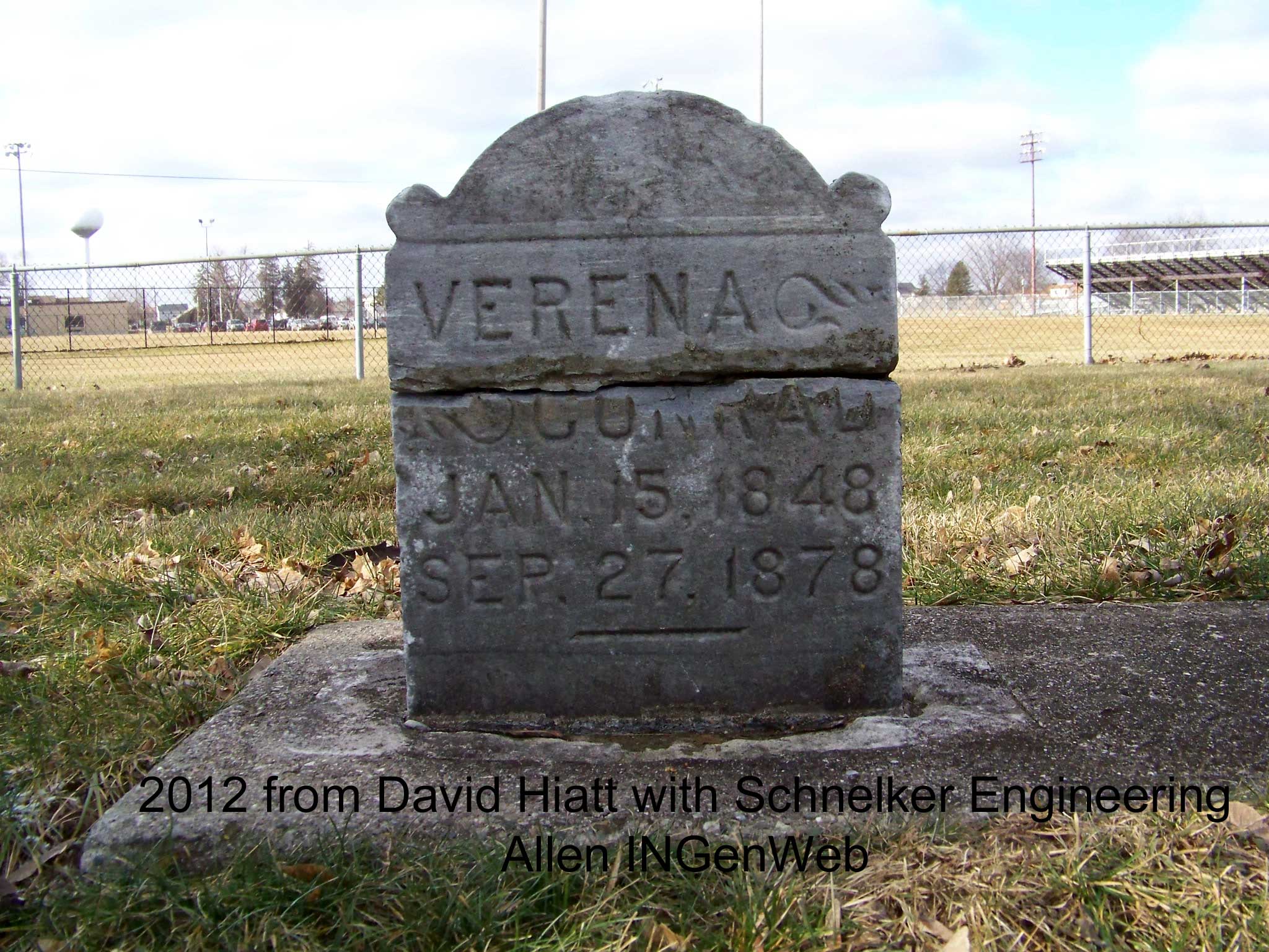
In January 2012 David Hiatt of Schnelker Engineering supplied these photos of the memorial stone for Graves Moved From Apostolic Christian Church Cemetery on Schwartz Road that lists 43 names. Only 2 names on the memorial have tombstones in the New Leo Memorial Cemetery. Since the road and the names in his photo are Schwartz, one would assume that is also be the correct spelling of the cemetery?
Mr. Viberg and wife are both consistent members of the Evangelical Lutheran Church. The sacred edifice wherein they worship is situated on one corner of Mr. Yiberg’s farm. The lot it occupies, and cemetery grounds adjacent, he donated the society; also contributed very largely toward the building of their house of worship. He has always given liberally in support of the organization, and has continuously served as one of its officers.


