Google maps are slow to load - wait for colored pins to show
View Allen County, Indiana Cemeteries in a larger map
Click on the green dot Wayne Township pin to see cemetery names.
Most city streets have Street Level View
Allen County Poor Farm Site
Was located near the intersection of Brooklyn Avenue and Bluffton Road. No longer exists.
The cornerstone laid June 19, 1859, and dedicated December 8, 1860. The persons who have the right to burial in the Crypt are Bishops of the Fort Wayne-South Bend Diocese.
Bounded by Calhoun, Jefferson, Lewis and Clinton Streets.
Almost the entire south half of the present cathedral square was used as a grave-yard. When the march of the future city began to encroach upon the cemetery, a great many of the remains were removed to sites more distant. When the new cathedral was begun, and later when excavations were made for library hall, wagon loads of bones were carted to grave-yards less disturbed by the stride of advancing life. It may interest some people to know that the remains of John B. Richardville, the whilom Canadian who became the famed Indian chief, were, however, not disinterred. They remained where they had been originally placed. The spot is just at the south edge of the cathedral, between the forward side door and the first buttress of the wall.
In 1830-31 Father Stephen Badin assisted Catholics of the area in purchasing a large part of what is now known as Cathedral Square. In 1857, Father Benoit laid plans to build a Cathedral. The Cathedral was built over the site of the Miami Indian burial grounds. Richardville, Chief of the Miami Indian's, DAR marker is located here facing Calhoun Street. IN DNR Latitude 41.0756 Longitude 85.1367.
DAR page says All of the remains were removed from the Cathedral Square Cemetery and are now located in the Catholic Cemetery, Adams Township. It is not known for sure if Richardville's remains were moved. There is however a tombstone in the Catholic Cemetery in Adams Township. This stone is located in section B of the cemetery.
Started by St. Paul's Lutheran Congregation. Earliest date is 1834, possibly moved from another location when this cemetery opened up for internments in 1850. Still in use.
Shown on early plat maps as being in the area of Wall Street and Swinney Avenue, near the Saint Mary's River. DAR page says it no longer exists. Many removed to Catholic Cemetery in 1873 on Lake Avenue.
Messrs. Barr & McCorkle, proprietors of Fort Wayne, in making their appropriation of lands for public purposes, set apart a tract four rods square as a free place of burial, and for church purposes. [Brice, p. 294.] This tract was located west of the present site of the Jail, and immediately north of Water street. “ In subsequent years, Judge Hanna having purchased all the Barr & McCorkle claims here, and the lots donated, as in the foregoing, being laid off by Mr. Hanna as a part of the place for general building purposes, the dead of the graveyard were, in 1837, removed at public expense or by loved friends, to the general cemetery west of Fort Wayne,” on Broadway. [Brice, p. 294.] From page 101 of the book History of Allen County, Indiana, Publication date 1880, Publisher Kingman Brothers on Archive.org.
1889
Judge Archer was of Scotch-Irish descent, of the Protestant faith, a whig in politics, of intellectual and moral sturdiness, and many mourned his loss when he died at Fort Wayne in 1833. The Masons, to which order he belonged, buried him in the old grave yard where the county jail now stands. His remains and those of his wife, who was a native of one of the Carolinas, and some grandchildren were afterward removed to the Broadway cemetery, but now nothing remains to mark their resting place.
More important than all other matters to come before the county commissioners in 1824, was the proposition of John T. Barr and John McCorkle, proprietors of the town plat which they had laid out in August. It included the offer to pay into the treasury of the county $500 cash, and to donate to the county "all of that oblong square piece of ground situate and being in the town of Fort Wayne aforesaid, and stained red on the plat of said town, as recorded in the recorder's office of Randolph county in said state [the present courthouse square] , which is granted as a public square, whereon public buildings for said county are to be erected, and bounded by Main, Court, Berry and Calhoun streets." The offer included also a lot at the northwest corner of the plat, four rods square, "for a church, to be of no particular denomination, but free to all," the unoccupied portion of which was to be used for a burial ground. In 1838 and 1839, Samuel Hanna, who purchased all of the unsold and unappropriated portion of the Barr and McCorkle holdings, arranged for the removal of the bodies of those buried in this cemetery to a new burial place (the present McCulloch park). The remains of one person, over-looked in the process of removing the bodies, were unearthed in April, 1916 — seventy-seven years after the cemetery had been abandoned. [Map of the Original Plat is shown on page 267]
Immediately south of Wayne’s fort, what is now Taber’s Addition, was the burial place connected with the garrison, but was, also, a general burial place Another place of burial was at the northwest corner of Columbia and Clinton streets and immediately to the westward thereof.
(3) Me-te-a died in Fort Wayne in 1827. The late Louis Peltier made the casket in which the body was buried. Peltier, who was born within the walls of the old fort, in 1815, conceived brush to grain the coffin.' " the idea of his life work while assisting to remove the skeletons of the fort soldiers from the military cemetery which was situated in the region of the "junction of the present Berry and Clay streets. This was while Mr. Peltier still was in his teens, and was engaged in learning the carpenter and cabinet- making trade with James Wilcox, whose shop was also the first under-taking establishment in Fort Wayne. In the beginning the undertaker was also the coffinmaker. The first person whose body Louis Peltier made the burial casket was Chief Me-te-a, whose tragic death was the result of taking - poison while conversing with friends in the silversmith shop of "Father" Be- quette. From the January (1880) issue of "The Casket," an undertakers' Jour-nal Published at Rochester, N. Y., the following interesting additional Infor-mation is taken:
"The coffine was of poplar and, as staing material was scarce at that time, Dr. Cushman furnished Venetian red. 'To gain the dark colr', said Mr. Petier, 'we burned oat straw and then secured General Tipton's whitewash brush to grain the coffin.'"
Soon after the burial of Me-te-a, Dr. Lewis G. Thompson had the body ex-humed in order to make an examination of the remains. "A noise was heard." says the late John W. Dawson, "which the company thought to be Indians: and. as they knew the savages were greatly hostile to such disinterments, they were at once panic stricken, and, quickly blowing out their lights, fled to the brush to await the denouement. False as the alarm proved to be. they were nevertheless suspicious of the nearness of danger. So, returning to the grave, they re-buried the body."
DAR page says no longer exists. Location of the Fort Wayne Post Cemetery is shown on early maps near the current intersection of Main and Lafayette Streets where one of the original forts is marked by a Wishing Well Memorial.
DAR says a marker was once located on an alley, off Leith Street, between Harrison Street and Hoagland Avenue, with the above name. No information could be found regarding this in 1981. Google map puts near 344 W. Leith Street. If you know anything about this cemetery please Contact Allen INGenWeb.
5800 Old Decatur Road, between Paulding and Tillman Roads
Private. Founded 1912. Mostly Russian Jews. There is a section of Lindenwood Cemetery that has a Jewish section, mostly German Jews. IN DNR Latitude 41.0261 Longitude 85.1233.
In the 20th century cemeteries used to have water spigots for watering plants. Lindenwood Cemetery used to have them too, have they been removed? See Plants page.
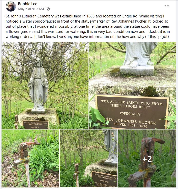
St. John's Lutheran Cemetery was established in 1853 and located on Engle Rd. While visiting I noticed a water spigot/faucet in front of the statue/marker of Rev. Johannes Kucher. It looked so out of place that I wondered if possibly, at one time, the area around the statue could have been a flower garden and this was used for watering. It is in very bad condition now and I doubt it is in working order..... I don't know. Does anyone have information on the how and why of this spigot?