Doyle Cemetery
Was located on north side of U.S. 30, east of the Doyle Road. No longer exists and no records found. If you know what happened to this rural cemetery please let us know. See DAR web page or Google map

Jefferson Township was organized in 1840
Part of New Haven straddles over the western border line from Adams Township as the major town in rural Jefferson Township.
Was located on north side of U.S. 30, east of the Doyle Road. No longer exists and no records found. If you know what happened to this rural cemetery please let us know. See DAR web page or Google map
North side of 11800 Edgerton Road, between Linden and Doyle Roads. East of New Haven between I-469 and Doyle Road, about a half mile west of Doyle Road on Edgerton Road, about a mile north of Dawkins Road / Lincoln Highway, a mile east of I-469.

Still in use. WHITNEY Family Cemetery is across the Road. The Emanuel Lutheran Church in New Haven, Adams Township has records of burials which date to 1853-1855. IN DNR Latitude 41.0786 Longitude 84.9869.
Go to: DAR tombstone photos, Find-A-Grave, or Google map.
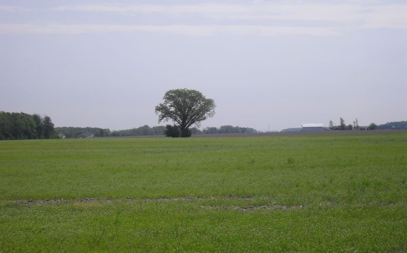
Located on private property in the middle of a farm field by a tree, south of Maples, on east side of Franke Road. Permission must be asked to gain access to this cemetery.
Earliest date September 11, 1861. Some removed to Wiltsy Cemetery, Antwerp, Ohio. Records no longer exist.
Go to: DAR Transcriptions, Find-A-Grave, Google map
Rural cemetery no longer exists. Was located on the Jacob Platt farm at the corner of Snyder and Paulding Roads.
There were about 25-30 burials at one time. This cemetery was abandoned in the 1930’s. Earliest tombstone was 1823. If you know what happened to the tombstones and burials let us know.
Go to: NSDAR 1932 transcription of 12 tombstone names and Google map
15351 Lincoln Highway East, old U.S. 30, Besancon, near the Berthaud Road, about ¼ mile west of the church.

Earliest date approximately 1930. Still in use. IN DNR Latitude 41.0511 Longitude 84.9425.
Go to: DAR tombstone photos, Find-A-Grave, or Google map
The Catholic Cemetery is situated in the northwestern part of Jefferson township, and there is also a German Lutheran church edifice in that vicinity.
Copied from page 644 of the book The pictorial history of Fort Wayne, Indiana : a review of two centuries of occupation of the region about the head of the Maumee River by Griswold, B. J. (Bert Joseph), 1873-1927; Taylor, Samuel R., Mrs, Publication date: 1917 on Archive.org.
15601 Lincoln Highway E, old U.S. 30, Besancon, adjacent to the church.

The church has been extended over part of the cemetery. Early French and German settlers. Also known as "New France". IN DNR Latitude 41.0511 Longitude 84.9375.
Go to: DAR tombstone photos, Find-A-Grave, or Google map.
South side of Edgerton Road, between Linden and Doyle Roads. Southeast across from Emanuel Lutheran Cemetery on private property.
The first death occurred in 1835, the victim being a child of Mr. Blackmore. It was buried on the home farm, on a little knoll opposite the house. About a year ago, a young son of James Post strayed iuto the woods, and was lost. A party of neighbors went in pursuit, and, after searching several days, found him in the Seven Mile Creek, drowned. There was no cemetery iu the township, and the remains were taken to Fort Wayne for interment. The first cemetery was established in 1838, on land donated for the purpose by Jared Whitney.
Page 153 of the book History of Allen County, Indiana, Publication date 1880, Publisher Kingman Brothers on Archive.org.
Earliest date 1838. . IN DNR Latitude 41.00778 Longitude 84.9861 puts it in the middle of a plowed field west of Maples.
Photos and discussion July 30, 2023 on Facebook.
James Post's residence was more transient than that of the Blackmores. The Posts took a station on Seven Mile Creek, but the year following, 1835, they pulled up their stakes and left, after suffering a tragic bereavement in the death of their little son, who strayed away from the cabin and was lost in the woods. After several days the searching party found the little lad drowned in Seven Mile Creek. No cemetery was yet established, and the body was taken to Fort Wayne for burial. Jared Whitney, in 1838, donated land for a township cemetery.
Copied from page 640 of the book The pictorial history of Fort Wayne, Indiana : a review of two centuries of occupation of the region about the head of the Maumee River by Griswold, B. J. (Bert Joseph), 1873-1927; Taylor, Samuel R., Mrs, Publication date: 1917 on Archive.org.
Located near Snyder and Paulding Roads. Early settlers. Cemetery was described in a farm deed. No longer exists. No markers remain. NSDAR lists this location as the Jacob Platt Farm Cemetery.
