Google maps are slow to load - wait for colored pins to show
View Allen County, Indiana Cemeteries in a larger map
Click on the violet Perry Township push pin to see the name of the cemetery
or click the link above to see all cemeteries.
Allen County Health Center Cemetery
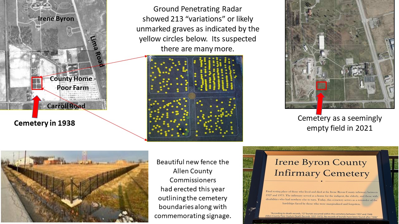
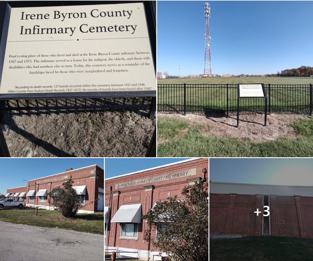
Irene Byron County Infirmary Cemetery
Black fencing is visible in July 2023 map based on Randy Harter September 18, 2023 Facebook post shown on Google Maps with Street View photo from Aerial View below. Older Google dates such as 2019 show old chain link fencing.
A big Thank You to Allen County Commissioner Nelson Peters for helping to preserve Allen County history. In 2021 at the urging of Nancy Parker, Charlie Pratt and myself, under Nelson’s direction Chris Cloud and Vance Hernandez from the county met us at the former County Home (Poor Farm) property on Carroll Road just west of Lima Road and walked the unmarked cemetery there where those who passed away at the County Home Infirmary were interred. Between about 1927 and 1948 hundreds of County Home burials took place on the property, however none of them were permanently marked. This property is now considered part of the greater Irene Byron property, but at the time Irene Byron and the County Home were separate entities. The county has had ground penetrating radar performed on the cemetery area (as shown) and identified at least a minimum of 213 likely gravesites. At one time a ledger book existed listing all those interred along with birth/death dates and burial lot numbers. Unfortunately, the ledger has been misplaced and/or no longer exists. While records do still remain for 127 of those interred, sadly no map exists that allows you to see the layout and locations of each of the individual unmarked grave sites in the now empty field. Nonetheless, it’s important that now the entire cemetery area has been identified and set aside by the County Commissioners from potential future development. Dan Baker, thanks for the images. Teamwork!
DAR on their Allen County Health Center Cemetery page, says This cemetery is located on a lane off Carroll Road, behind the County Home, in Huntertown IN. There are no markers. Therefore there will be no transcriptions or photos of this cemetery.
Find-A-Grave has over 180 names from various sources such as death certificates and newspaper obituaries.
SHAARD Indiana State Historic Architectural and Archaeological Research Database (SHAARD) IN DNR has a three page pdf map. IN DNR Latitude 41.1928 Longitude 85.1733.
Was occasionally referenced in newspaper articles as the county discusses what to do with the property after the Allen County Sheriff moved their offices to Fort Wayne in 2012.
We know where the old cemetery was, but we want to make sure there aren’t any more graves, said Barry Sturges, the local developer who is helping prepare the site for other uses once the Byron Health Center moves to its new location on Lake Avenue later this year. The graves are remnants of the old Byron Sanitarium, which treated tuberculosis patients between 1919 and 1976. Copied from Before county sells Byron property, it wants to know where the graves are by Kevin Leininger, posted Februray 21, 2020 in
The News-Sentinel newspaper
The original grounds on Lima Road had at least one graveyard. In 2020, the county hired American Locating Services of Indianapolis, to use ground-penetrating radar to look for caskets or bodies according to the newspaper article County to look for possible graves Commissioners hire surveyor to study Byron property by Rosa Salter Rodriguez, February 22, 2020, The Journal Gazette newspaper archived on the Internet Archive Wayback Machine. It also stated: The need for the study came a few months ago when a longtime area resident told county officials he remembered seeing a second graveyard on the site when he was a teenager in the 1960s to 1970s.
East of Huntertown across from the New Huntertown Cemetery on the south side of West Cedar Canyons Road at Dunton Road. 0.7 miles east of State Road 3
The First Cemetery was purchased from a Mr. Blair by residents of the township, in 1834, and is still used as a place of interment. Its first occupant was a Mr. Valentine, who was drowned in Cedar Creek in 1834. In the same year, E. R. Burk died, and his remains were consigned to rest in the same place. The cemetery is located one mile east of Huntertown on Section 16.
Robinson Chapel. —In 1851, Andrew Byers donated a tract of land to the Methodist Episcopal denomination to be used as a cemetery, and also as the site for a church of that denomination. The society was organized in the preceding year, and held meetings at the schoolhouse until 1852. In that year, they erected a frame church on the land donated by Mr. Byers. It was dedicated by Prof Robinson for whom it was named. Rev. Ira M. Wolverton is the present Pastor.
Robinson Chapel was a second building of the same denomination, in 1851, the land for the chapel and also for a cemetery, being donated by Andrew Byers.
Earliest date August 3, 1848. This cemetery is no longer in use. This cemetery has been moved to the northwest corner of the church property. Many of the stones have been replaced. GPS Coordinates: Latitude: 41.20151 Longitude: -85.07841.