The city of Fort Wayne straddles the eastern township line in the increasingly suburban Aboite Township.
Active cemeteries still accepting burials usually have an office or sign near an entrance with a contact phone number. Most cemeteries originally had a sexton who kept the records for burials, maintained the cemetery, and lived close by. A local funeral home may know if original burial records exist for inactive cemeteries. Church graveyard records may be with the church if still active or its successor. Rural cemetery burial records are sometimes kept by a longtime local business nearby such as lawn tractor business or barber shop. Large cemeteries may have a dedicated paupers burial area such as at Lindenwood or the Catholic Cemetery often with no visible markers. The office would know if such areas exist. It is likely many were buried in nearby burial grounds without permanent markers.
The Mary Penrose Wayne Chapter NSDAR Allen County Indiana Cemetery Project made cemetery readings in 1932 that may contain information available no where else. In 1982 the Allen County Genealogical Society of Indiana updated the cemetery readings that revealed many tombstones from 1932 were missing. The results were published in Cemetery Township books available on their www.acgsi.org website and at
The Genealogy Center at the
Allen County Public Library in Fort Wayne, Indiana. The NSDAR starting taking photographs in 2008 of every existing tombstone at over 147 cemeteries in twenty townships over several years and published them on their website stating: "there are over 165,000 photos on this web site. And transcriptions for over 219,000 people." "Member volunteers visited each cemetery and photographed each tombstone. The tombstones were then transcribed exactly as they were written. There is no other information on any person other than what is listed." They have a Master Name Index.
All known Indiana cemeteries have been surveyed by SHAARD Indiana State Historic Architectural and Archaeological Research Database (SHAARD) and whatever information was found sometimes including history, maps, and photos is on their website.
Progress in motion! 🚧 Our bridge renovation is coming together, with completion expected by the end of October. Excited to see this project soon serving our community!
Progress in motion! 🚧 Our bridge renovation is coming together, with completion expected by the end of October. Excited to see this project soon serving our community!
Oak Grove - Bullard Family - Sleepy Hollow Cemetery
Street View photo from Google maps
City cemetery near 3801 Sleepy Hollow Lane,
East side of West Jefferson Boulevard near Aboite Center Road. Oak Grove Cemetery was originally the Bullard Family Cemetery located on Bullard Family land in Aboite township copied from a January 26, 2024 post by the Friends of Oak Grove Cemetery on Facebook.
Presentation of the Oak Grove Cemetery Restoration Project (650 graves), by Aboite (Fort Wayne) Township Trustee, Ms. Kimberly Mills to the Anthony Halberstadt Chapter on December 02, 2023. The Chapter has agreed to partner with the Township and assist in the restoration. Pictured is Chapter President Jeff Jones, agreeing with a Chapter Motion, to donate $100 of initial “seed” money.
With the approval of the Aboite Township Trustee, the Oak Grove Cemetery, Friends of the Cemetery Volunteers are implementing a long term, comprehensive plan, of restoration and repair of Oak Grove Cemetery.
Please like this page if you are interested in this historic pioneer cemetery.
Thomas Z Babcock Co I, 125th Ohio. (The Fort Wayne News, 15 Jul 1902, Tue page 4)
Rev. Chauncy H. Bell 1847 – 1925 His wife Nancy L. Indiana Co G 142nd volunteer Inf.
Dr Warren L Biddle, Pvt US Army WWII.
William C. Bowman, Indiana Co E 47 Inf. Enlisted on 3/21/1864 as a Private. On 3/21/1864 he mustered into "E" Co. IN 47th Infantry.
Enoch Clark March 3, 1831 – September 19, 1912 (Old Section) 81 years 6 months 16 Days Indiana 152nd Volunteer Inf. Born Easthampton Shore MD. 102 d.
Frank E Coolman 5 September 1899 – 13 February 1962 Arkansas Pvt. Co B 32 Engineer Bn. WWII.
George M. Coolman 6 October 1903 – 7 March 1962 Indiana Pfc. 411 AAA Gon Bn CAC WWII.
Jos E Corlett Illinois Co K 156 Inf.
George W. Denner August 3, 1922 – July 19, 1973, Illinois Cpl. US Marine Corp WWII
David Eggiman 1842 – 1915 his wife Lavina Kepple Indiana Co K 11 Cav
Erastus H Grove Co C 49th Ohio Inf Fostoria, Ohio, May 31st, 1846 – Nov 26, 1923
Benjamin F. Haines died aged 72 years 5 months 8 days. May 11, 1904. Co. E. 142 Indiana Inf. Buried with wife Margaret d. sept 23 1904. Aged 64 years 7 months 28 days.
Hugh Hamilton, private Co G 159th IN V Inf Spanish War.
Louis C Horstmeyer 3 July 1890 – 12 Oct 1961 Indiana Pvt Co A 25 Machine Gun Bn WWI.
Ora Lee Dec 12, 1887 – Mar 20, 1957, Indiana Pfc Quartermaster Corp WWI.
Samuel S Lee Co D 78th Ohio Inf
Lewis Mumaugh (1834 - 1913) enlisted as private on 2 May 1864 at age of 29 and mustered into Co C 151st Inf Regt OH on 13 May 1864; mustered out Co C 151st Inf Reg OH, on 27 Aug 1864 at Camp Chase, OH. No Marker
John Smaltz Private Co D 5th Cav. Indiana Volunteers. Born July 17, 1838, Died of injuries received in action at Hillsboro, GA August 15, 1864.
Floyd E Smeadler July 31, 1926, Indiana Engineman 1 C 1 US Navy
John E. Stilts, Born December 15, 1844, Died August 6, 1885. Co D. 5th Reg Indiania Volunteer Cavalry. Enlisted on 8/1/1862 as a Private. On 8/1/1862 he mustered into "D" Co. IN 5th Cavalry. He was discharged for wounds on 11/11/1864. Wounded 9/4/1863 (place not stated) (Severely wounded in left leg, amputated. Surgical operation 4/22/1864 (place not stated) (Re-amputation of left leg.)
Asa Turner 1838-1926. Elizabeth his wife 1852-1923 Co. D. 30 Indiana Inf. Co G. 152 Indiana Inf. Mr. Turner served in the Thirtieth and One Hundred and Fifty-Second Indiana Volunteers during the Civil War.
Alexander Votra Co D. 88 Indiana Inf
William H Williamson Oct 10, 1897 – March 18, 1965, Indiana Pfc US Army WW I
Women's History Month for March Friends of Oak Grove Cemetery recognizes Rosamond Dawson Bullard the wife of George...
Women's History Month for March Friends of Oak Grove Cemetery recognizes Rosamond Dawson Bullard the wife of George Bullard. Rosamond was born in 1802, and died in 1886. Rosamond and George Bullard had eleven children. She lived to the age of eighty-three years, but never used glasses, being able to read a paper by candlelight, and thread a needle.
Rosamond and George's monument has a hand with one finger pointing up usually indicating that the soul has risen to the heavens.
21Country: Remembering Oak Grove Cemetery April 17, 2024 ABC21 WPTA on YouTube
Around 0:40 the first generation knows, the second generation remembers, and the third generation or more forgets. Eric Olson shares what a local chapter of the Daughters of the American Revolution is doing in Aboite Township to remember Oak Grove Cemetery and honor those buried there.
Oak Grove Cemetery Historic Cemetery sign was installed today.
Congratulations to the Oak Grove Cemetery for their new marker. (Our Chapter helps sponsor this cemetery)
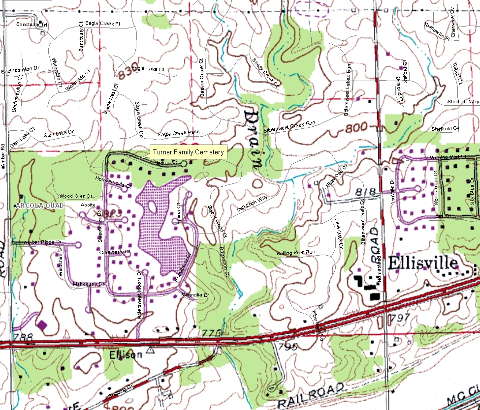
Turner Family Cemetery
11780 Indigo Drive Bittersweet Moors housing development, Street View photo from Google Maps
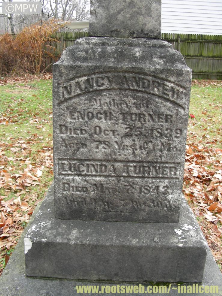
Earliest tombstone date was 1834.
Tombstones with names matching the 1932 DAR readings were seen over the years away from the cemetery location. If you know what happened to the tombstones let authorities know.
This concerns the Turner Family Cemetery and the site of the Friendship Church and School which both lie on common ground within the Bittersweet Moors subdivision north of Indigo Drive (see Photos - Timeline Photos). This defunct cemetery contains nineteen graves [1], including some of the first settlers of Aboite Township. This small group of pioneers, along with Jesse Vermilyea, arrived in 1833 and was known as the Maryland Settlement [2]. One couple buried here, Mary Ann and Martin Kelley, were the first to be wed in the township [3]. Mary Ann's parents, Richard and Sallie Andrew, are also buried here. Richard Andrew became a Justice of the Peace during the first election held in the township [4]. George M. Crouse, a Civil War veteran of the 5th Cavalry, Indiana Volunteers, died in Annapolis, Maryland in 1864 [5] (ref. Company D roster on p. 461) and was buried in this cemetery. The Friendship Church and School was a log structure that served as both a school and place of Methodist worship until approximately 1880 [6].
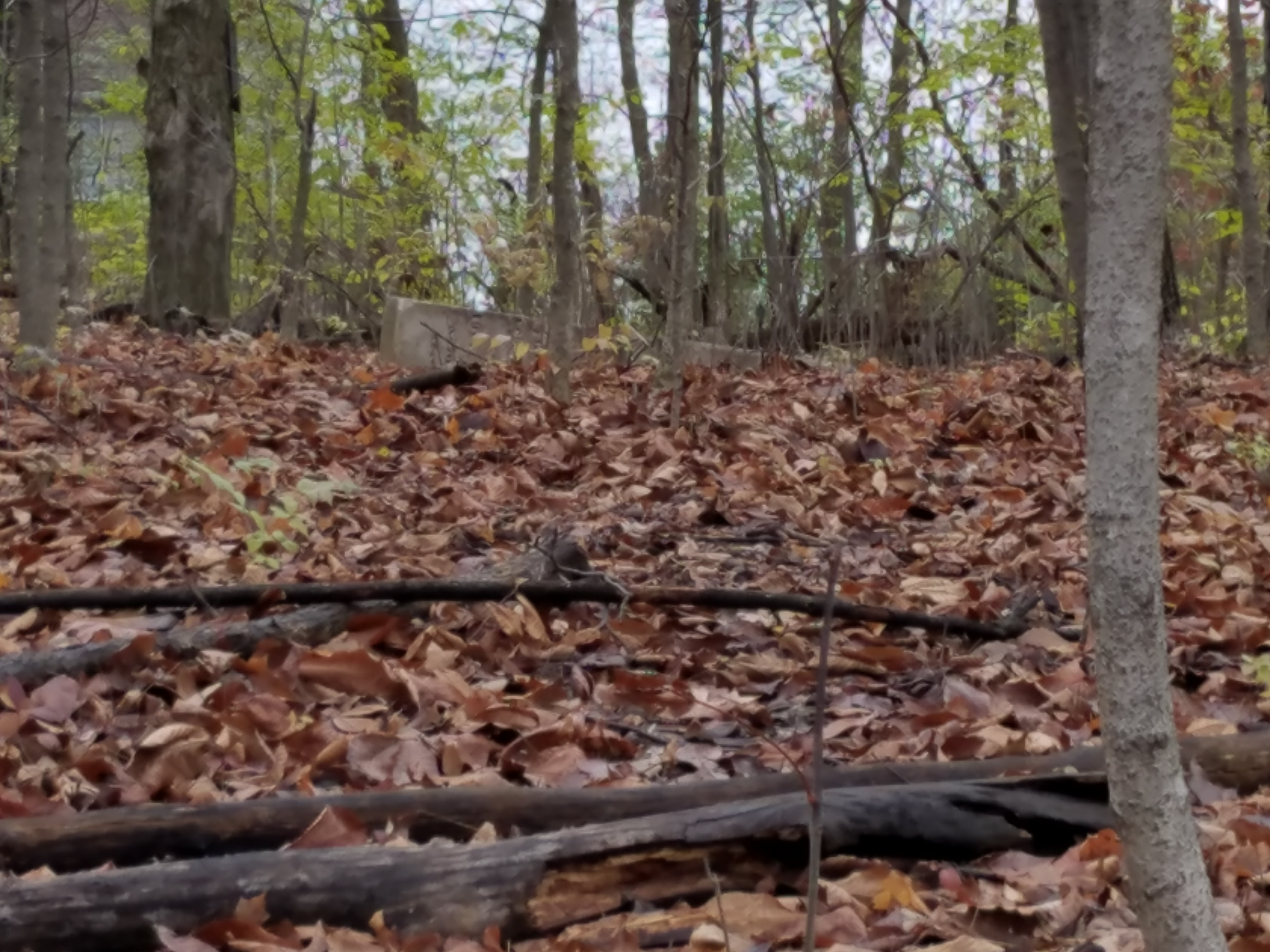
Early in 2013, I began a campaign to clean up and preserve what is left of the cemetery with assistance from the Indiana Division of Historic Preservation and Archaeology through their Indiana Pioneer Cemeteries Restoration Project. I had received offers to help from members of the Mary Penrose Wayne Chapter of the NSDAR. Due to opposition within our association board of directors, I failed to receive approval to proceed. The response that I received from the board president at the time was to stop contacting outside agencies or officials. With encouragement I received from a couple of such officials, I recorded my findings. In addition to this Facebook page, there are photos with references at www.findagrave.com [7] to help spread public awareness.
As of August, 2015, we have several new members on our association board of directors [8]. Although, I believe, there is still little chance of receiving approval for any type of restoration, my goal is to simply prevent any future desecration of the graves and to recognize the site's historical significance. Only the large gravestone of Richard and Caleb Clark is visible in the cemetery. The overgrown woodlot has suffered through decades of neglect, vandalism, and yard waste from nearby resident properties. I was informed by a member of the Allen County Genealogical Society that in 2012 a number of gravestones from the Turner Cemetery were found in the back yard of the home at 3326 Oliver Street, Fort Wayne. The Fort Wayne Police Department became involved but let the issue drop when it was determined that the gravestones had been there for a long time. My hope is that some type of historical marker can be erected. From what I have been reading, this type of site would probably not be eligible for an Indiana State Historical Marker. Would it be possible to obtain a marker at a more local level? In addition to this, I would like to see some "No Dumping" signs erected to minimize the future use of this woodlot as a dumping ground by Bittersweet Moors residents as well as from the Eagle Creek subdivision that borders the north side. Of course, I would need to obtain board approval for the erection of any signs.
Although Indigo Drive is a cul-de-sac, it has a significant amount of bicycle and foot traffic due to the abundance of sidewalks within the area. These are part of the Aboite Trails network [9].
02-5 survey form.pdf Cemetery Registry Survey Form, north of U.S. 24 and west of Homestead Road, 11790 Indigo Drive. Under Bittersweet Moors housing development. At least 19 burials with no stones.
The first cemetery was donated by Enoch Turner in 1834, and the space allotted for interment is now nearly all occupied. The first corpse here interred was that of a young Irish boy, who had been adopted into the family of Jesse Vermilyea.
The burial ground is now located in the Bittersweet Moors housing development. The Indiana DNR SHAARD Cemetery Registry lists the cemetery location as 11780 Indigo Drive in Section 28, Township 30N, Range 11E, with GPS Latitude: 41.0230, Longitude: 85.2965 which describes the 160-acre parcel that Enoch Turner purchased from the General Land Office of the United States on 2 September 1834.
Enoch Turner donated the ground for a cemetery in 1834, and afterward gave land for a log church which was built in 1842, and used for that purpose and also for a school-house for many years. This structure, called the Friendship Church and School was built on land next to the cemetery.
Enoch Turner's first gift to the community was a lot for a cemetery, the first burial made there being that of a little Irish lad whose pathetic story draws the tribute of a passing sigh. The son of an inebriate father who had drifted into the settlement, and whose fragile wife had died from neglect, Mr. Vermilyea befriended him, but the help came too late.
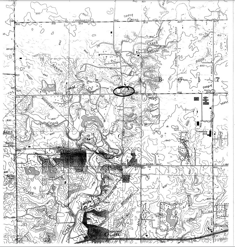
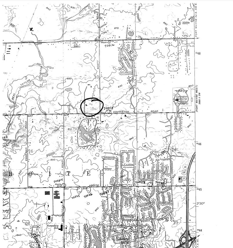
Possible location map image from SHAARD Indiana State Historic Architectural and Archaeological Research Database (SHAARD)
No longer exists. Formerly located on the Aboite Road, west of Scott Road. Was not located in 1982 for the tombstone readings. Indiana DNR location lists as
Section 10, Township 30N, Range 11E. From Mary Penrose Wayne Chapter NSDAR page.
If you know anything about the location and what happened to the tombstones of this cemetery please let us know.
SHAARD Indiana State Historic Architectural and Archaeological Research Database (SHAARD)


