Adams Township Cemeteries

Adams Township was organized in January 1826, then reduced to its present size in May 1830

Google maps are slow to load - wait for colored pins to show

View Allen County, Indiana Cemeteries in a larger map
Click on red Adams Township pins to see cemetery names

Fort Wayne straddles over the western township line as the main city and New Haven is the main town in increasingly suburban Adams Township.

  1. Go to:
  2. Adams Family Cemetery
  3. Adams Township Cemetery
  4. Catholic Cemetery
  5. Concordia Gardens Cemetery
  6. Connor's Cemetery
  7. German Evangelical Cemetery
  8. I.O.O.F. Cemetery
  9. Koehlinger Cemetery
  10. Martini Cemetery
  11. St. John's Cemetery
  12. Tilbury Cemetery
  13. Trier Cemetery
  14. Trinity Cemetery

Active cemeteries still accepting burials usually have an office or sign near an entrance with a contact phone number. Most cemeteries originally had a sexton who kept the records for burials, maintained the cemetery, and lived close by. A local funeral home may know if original burial records exist for inactive cemeteries. Church graveyard records may be with the church if still active or its successor. Rural cemetery burial records are sometimes kept by a longtime local business nearby such as lawn tractor business or barber shop. Large cemeteries may have a dedicated paupers burial area such as at Lindenwood or the Catholic Cemetery often with no visible markers. The office would know if such areas exist. It is likely many were buried in nearby burial grounds without permanent markers.

The Mary Penrose Wayne Chapter NSDAR Allen County Indiana Cemetery Project made cemetery readings in 1932 that may contain information available no where else. In 1982 the Allen County Genealogical Society of Indiana updated the cemetery readings that revealed many tombstones from 1932 were missing. The results were published in Cemetery Township books available on their www.acgsi.org website and at The Genealogy Center at the Allen County Public Library in Fort Wayne, Indiana. The NSDAR starting taking photographs in 2008 of every existing tombstone at over 147 cemeteries in twenty townships over several years and published them on their website stating: "there are over 165,000 photos on this web site. And transcriptions for over 219,000 people." "Member volunteers visited each cemetery and photographed each tombstone. The tombstones were then transcribed exactly as they were written. There is no other information on any person other than what is listed." They have a Master Name Index.

All known Indiana cemeteries have been surveyed by SHAARD Indiana State Historic Architectural and Archaeological Research Database (SHAARD) and whatever information was found sometimes including history, maps, and photos is on their website.

The 1878 Atlas of Adams Township shows a cemetery on the north side of the Maumee River in Section 5. The 1900 Plat Map shows the Herman Aldding Catholic Cemetery in Section 5. 1907 Map shows Cath. Cem. near H. J. Alerdine 120 and a Cemetery in Section 9.

ADAMS Family Cemetery

No Adams Family Cemetery on 1898 Atlas map

No cemetery is indicated in sections 3, 2, 10, or 11 which would match the area along Parrot Road circled in the SHAARD Adams.pdf from Adams Township of the 1898 Standard Atlas of Allen County, Indiana by Geo. A Ogle at Historic Map Works or Adams Township on page 58 of the Standard atlas of Allen County, Indiana : including a plat book of the villages, cities and townships of the county ... patrons directory, reference business directory ... by Geo. A. Ogle & Co. cn on Archive.org. The Adams Township Cemetery is visible south of the Wabash Railroad tracks in the southwest quarter of the northeast quarter of Section 9 south of School No 4 and the I.O.O.F. Cemetery is in the southwest quarter of the southeast quarter of Section 11.

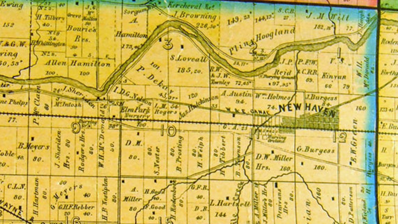
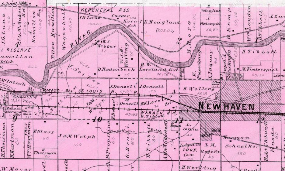
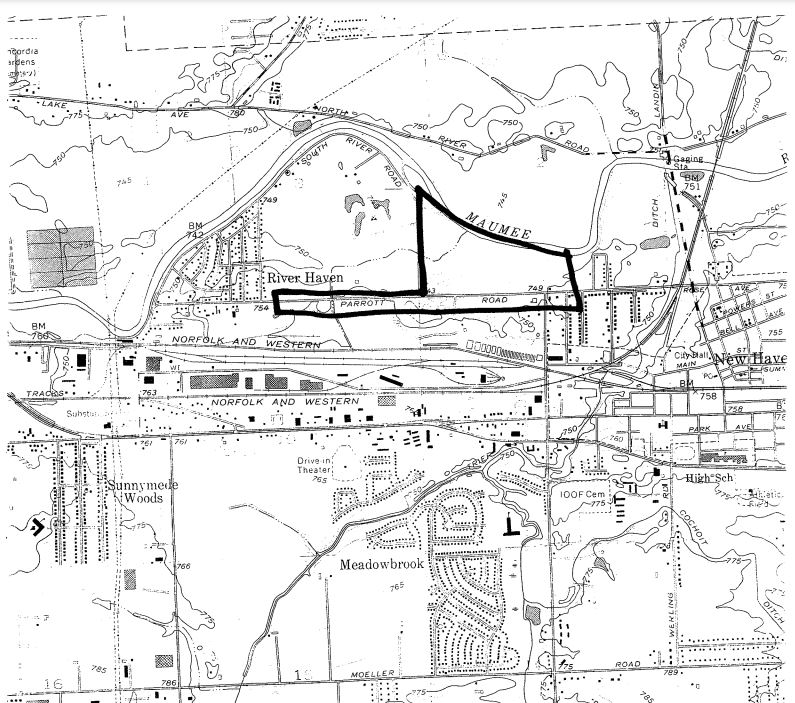
Was on Parrott Road about two miles west of New Haven. Parrot Road goes east at Maplecrest Road which didn't open until October 30, 2012. Parrot Road becomes Estella Avenue going south on the west side of Maplecrest Road, while the Parrot Road name changes to Rose Avenue at Hartzell Road. Parrot Road is the first road north of the northern set of railroad tracks while the similar named Adams Township Cemetery is south near the the southern set of railroad tracks.

  1. NSDAR Adams Family Cemetery No tombstones remain so no photos are on the page.
  2. Allen INGenWeb Google map.

SHAARD Indiana State Historic Architectural and Archaeological Research Database (SHAARD)

  1. Survey Number CR-02-8
  2. 1825-1852 exact location unknown
  3. Adams.pdf shows circled general area on Parrot Road on a map and same Allen County Lines information as above
  4. 02-8 Survey Form pdf says established 1852 (typo?) with first burial in 1825, most but not all graves moved in 1875, moved the rest to a common grave in 1981 at IOOF Cemetery - see An Old Pioneer Cemetery in the third box below.

    Mr. Adams, who came from Rochester, N. Y., and settled near New Haven, was a man of much ability, and gave the township subsequently formed his name, not in his own honor, he declared, but in memory of John Quincy Adams. The closing years of his life were spent in Jefferson township. A daughter of this pioneer died in 1825, and was buried upon his farm, where a second interment, the bodv of Mrs. James Thatcher, was made in 1828. The spot became the cemetery for a large district, but the established cemetery afterward was upon land donated by D. W. Miller, in 1830, which is now included in the beautiful cemetery maintained by the Odd Fellows since 1875.

    Copied from page 206 of the book Valley of the upper Maumee River, with historical account of Allen County and the city of Fort Wayne, Indiana Volume 1, Publication date 1889 on Archive.org.

    CEMETERIES.

    The burial of the daughter of Jesse Adams, in 1825, consecrated that portion of his farm, and, in 1828, a second interment was made in the same place— the body being that of Mrs. Thatcher, wife of James Thatcher. From that date this spot was known as the Adams Cemetery, and received many occupants from this and neighboring townships.

    From page 142 of the book History of Allen County, Indiana. Publication date 1880 Publisher Kingman Brothers on Archive.org.

    AN OLD PIONEER CEMETERY in the December 1981 Allen County Lines quarterly publication in the Membership section of the Allen County Genealogical Society of Indiana website.

    In August, 1981 at an excavation site on the Parrott Road, about two miles west of New Haven, workers excavating sand to fill ditches for a sewer project found a graveyard that had not been used for more than 100 years. The Adams Township Trustee said he had no records on a graveyard there.

    He stated that early Allen County history books referred to the graveyard as the Adams Cemetery. It was in a deed dated Oct 1, 1852 as a tract of land now used as a Burying Ground twelve rods long east and west and 6 rods wide north and south. Records indicate the first burial sequence occurred in 1825, the daughter of Squire Jesse Adams on the Adams farm. The second burial occurred three years later and others followed, the names of whom are not recorded and are unknown. The cemetery was part of the Adams farm and was used by him and other area residents.

    In 1875, some of the graves were exhumed and re-entombed in the IOOF Cemetery on Hartzell Road when it was re-established. Evidently not all the graves were moved ... but the exact number and names were not recorded. There is no way to know how many graves remained. The Adams Cemetery has had no burials for more than 100 years, and it has not been maintained; there are no gravestones or other outward signs of burials.

    Since the cemetery is located on a sandy tract, near the Maumee River, without access to any public road, and being used for excavation of sand and gravel, it is impossible for the Trustee to maintain it at its present site.

    Lynn H Shaw, Adams Township Trustee, petitioned the Allen County Superior Court for permission to remove the remaining graves and re-bury them in the IOOF Cemetery at New Haven in a common grave.

    The common grave will be marked with a single monument. Dedicated to "The early settlers of Adams Township."

    Second page of the SHAARD report Adams.pdf


    Jewish tombstone photo
    The Journal Gazette newspaper photo on
    the Wayback Machine

    Steven Greenberg, a writer from Israel who is in town visiting family, translated the stone as “The child Kileh daughter of Yehuda Maher Katzenshek ... Berlonpek ...” something similar to “may her soul rest in peace. “It’s definitely the headstone of a Jewish grave,” said Rabbi Meir Bargeron of Fort Wayne’s Congregation Achduth Vesholom. The Adams Family Cemetery on Parrott Road and Adams Township Cemetery west of Estella Avenue on Old Maumee Road near Maplecrest Road and the railroad tracks are both within a mile or two of this Save Maumee cleanup site at 501 Rose Avenue, New Haven, Indiana. Rose Avenue becomes Parrott Road at Hartzlett Road as it goes west shown by the red pins on our Google map above. Copied from Site cleanup unearths headstone Earth Day volunteers with Save Maumee find Jewish marker by James D. Wolf Jr. published April 24, 2022 in The Journal Gazette newspaper with the tombstone photo above.

    Site cleanup unearths headstone Earth Day volunteers with Save Maumee find Jewish marker is also the Internet Archive Wayback Machine.

    See Save Maumee Grassroots Organization on Facebook or their website: https://savemaumee.org/. This newspaper article was discussed April 24, 2022 on True Fort Wayne Indiana History on Facebook.

    The MaryLands Farm Park located on the Jesse Adams farm land is to open almost 200 years later in 2024.

Adams Township Cemetery

Street View photo from Google Maps see Google Aerial Maps
General location of the area behind the AEP Lincoln Substation on Estella Avenue at Old Maumee Avenue north of Indiana 930 west of Maplecrest Road.

October 2008 Street View photo shows more trees and a dirt road near the middle of several conifer trees. Same location in August 2011 and May 2023. Have to wonder where the tombstones in 2008 DAR photos were located in relation to this dirt road?

This abandoned cemetery is behind the AEP substation west side of Estella Avenue, south of Old Maumee Road in New Haven, near the railroad tracks and east of the Maplecrest Road extension which didn't open until October 30, 2012.

  1. DAR tombstone photos show Catharine and Joseph Ludwick's tombstones.
  2. Allen INGenWeb Google map

SHAARD Indiana State Historic Architectural and Archaeological Research Database (SHAARD)

  1. Survey Number CR-02-9
  2. West of Estella Avenue, south of Old Maumee Road, New Haven. Reportedly moved in early 20th century
  3. 02-09 Survey Form pdf - exact location unknown
Adams Township Cemetery in Section 9 of 1898 Atlas

Adams Township Cemetery is indicated by the letters cem in the southwest quarter of the northeast quarter of section 9 on the land of G Theisman south of the Wabash Railroad tracks in Adams Township of the 1898 Standard Atlas of Allen County, Indiana by Geo. A Ogle at Historic Map Works or Adams Township on page 58 of the Standard atlas of Allen County, Indiana : including a plat book of the villages, cities and townships of the county ... patrons directory, reference business directory ... by Geo. A. Ogle & Co. cn on Archive.org. Today it is west of Estella Avenue, south of Old Maumee Road.

The first burial date is September 10, 1861. The NSDAR states on their web page: This cemetery is no longer in use. The cemetery had been abandoned and could not be located when the Allen County Genealogical Society did cemetery readings in the 1980’s. In the fall of 2008 AEP contracted to have the right-away behind the substation cleared and the stones were rediscovered. The cemetery was photographed and transcribed in October of 2008. Since that time it has been reported that the stones have been stolen.

In 1830, D. W. Miller gave a portion of his farm tor a public cemetery, and the body of James Townsend was the first interred there. It became the established cemetery of the township, and many of the pioneers now sleep within its precincts. In later years, its fences were permitted to go to decay, and many of its graves are now sadly neglected, and overgrown with grass and weeds.

From page 142 of the History of Allen County, Indiana. Publication date 1880 Publisher Kingman Brothers on Archive.org.

  1. A 2016 newspaper article says gravestones and bodies were moved in the 1920s to the I.O.O.F Cemetery on Hartzell Road. See Epitaph for mystery marker So what’s a century-old tombstone doing under a bridge? by Frank Gray published March 8, 2016 in The Journal Gazette newspaper now on the Internet Archive Wayback Machine.
  2. John A. Thompson 1847-1872 was the subject of the newspaper article's granite replacement gravestone in the I.O.O.F. cemetery.
  3. March 8, 2016 post by Allen County Genealogical Society of Indiana on Facebook.
Back to top

Catholic Cemetery

Current Street View photo from Google maps
Google Street View photos go back to 2007 showing the previous entrance and fencing.
The current entrance was updated somtime between 2011 and 2015.

3500 Lake Avenue, Fort Wayne, Indiana 46805-5572
Devine Mercy Funeral Home Catholic Cemetery https://www.divinemercyfuneralhome.com.

Traditionally called the Campo Santo, God's Acre, and the Reliquary of Saints. Modern cemetery office on the west side of 175 acre cemetery operated by the Catholic Cemetery Association. There were around 29,000 graves in 2008. The original Catholic Cemetery was on Cathedral Square in downtown Fort Wayne. A larger cemetery was then located on Swinney Avenue and Wall Street. After only 29 years the need arose for another larger location. In 1872, Bishop Joseph Dwenger purchased 120 acres, on Maysville Road one mile outside the city limits of Fort Wayne. Today it is called Lake Avenue. The bodies were removed from the other township cemeteries into the present location. The cemetery was then opened for interments in 1873. The Old Catholic Cemetery with maps is discussed on our ACGSI.org site. It includes a newspaper article titled Bones discovered under Superior Essex parking lot.

The old Catholic Cemetery was in service from about 1849 until 1873 on land that is now Swinney Addition. See maps and newspaper articles, including a 2002 newspaper article when bones were found under the Superior Essex parking lot on the Old Catholic Cemetery Fort Wayne, Indiana page on the ACGSI web site. Superior Essex is located at the corner of Taylor and Phenie Streets shown in the Street View Google Maps.

Celebrating 150 Years 1873 - 2023

November 25, 2023 Celebrating 150 years 1873-2023 advertisement in The Journal Gazette newspaper

  1. ACGSI cemetery plat maps
  2. Allen INGenWeb Google map
  3. BillionGraves over 30,000 records
  4. Find-A-Grave photos over 37,000 memorials
  5. Fort Wayne Catholic Cemetery through 1993 at The Genealogy Center at the Allen County Public Library in Fort Wayne, Indiana.
  6. Friends of Allen County section map
  7. NSDAR tombstone photos

SHAARD Indiana State Historic Architectural and Archaeological Research Database (SHAARD)

  1. Survey Number CR-02-13
  2. Latitude: 40.0871; Longitude: 85.0936
  3. Established in 1872, first burial in 1873
  4. Catholic Cemetery section map
  5. Catholic.pdf - six page maps, aerial photos
  6. 003-214-26469.pdf map
  7. 02-13 survey form.pdf Cemetery Registry Survey Form, established 1872

January 13, 2011 postcard ca. 1910 posted by the original Great Memories and History of Fort Wayne, Indiana page on Facebook.

Chief Richardville Monument
Chief Jean Baptiste Richardville memorial photos, Catholic Cemetery, Fort Wayne, IN, 1920s. (2)
from the Bert J. Griswold Collection of Fort Wayne History in the Allen County Public Library Digital Collections at the Allen County Public Library.
Label: Monument, now in the Catholic Cemetery, Fort Wayne, Erected to the memory of the Chief Richardville, by his three daughters.

NOTE on opposite page: and the indifferent workman allowed the strange Indian to carry away all the other relics except the bones which were reinterred. At least three bodies were disturbed, suggesting that the Indian burial ground was quite an extensive one, as the supposed grave of Little Turtle, together with other graves which have been disturbed in tits immediate vicinity, is four squares north of this spot, in Lawton Place. Possibly this was a separate burial place. -- B. J. G.

Page 97, (33) The Chillicothe village was located a short distance down the Maumee, probably on the site of the present Catholic cemetery.

Page 225

THE CHIEF RICHARDVILLE MONUMENT. The monument raised over the burial place of Chief Jean Baptiste de Richardville, in the present Cathedral square (the south half of which was used originally for a burial ground), was, at the time of the removal of the bodies to the Catholic cemetery in the southwestern part of the city, taken to the new burying ground, although the body of the Miami chief was allowed to remain In its original grave. Later, the monument was removed to the present Catholic cemetery, northeast of Fort Wayne. The small shaft of white marble was erected by the chief's daughters, Catherine, La- Blonde and Susan. While standing in the old cemetery, on the bank of the St. Mary's river, directly south from the Pennsylvania tracks, the monument became marred by sportsmen, who used it for a target in order to carry away its chips as souvenirs. It was removed to its present site by a granddaughter. Mrs. Archangel Engelmann, of Huntington, Indiana (daughter of Catherine, the wife of Chief LaFontaine). One panel bears the inscription: "Here Rest the Remains of John B. Richardville. Principal Chief of the Miami Tribe of Indians. He Was Born in Fort Wayne. Indiana, About the Year 1760, and Died in August. 1841." The resting place of the body of Richardville is described as a spot "just at the edge of the Cathedral, between the forward side door and the first buttress of the wall."

Copied from the book The pictorial history of Fort Wayne, Indiana : a review of two centuries of occupation of the region about the head of the Maumee River Volume 1 by Griswold, B. J. (Bert Joseph), 1873-1927; Taylor, Samuel R., Mrs, Publication date: 1917 on Archive.org.

August 13, 2022 post by The History Center on Facebook:

Born in 1761, Jean Baptiste Richardville (Pinšiwa) was the son of a French fur trader father and a Miami Indian mother named Tacumwa, sister to the Miami war chief Little Turtle. Richardville and his mother built a trading empire based on control of the “long portage” between the St. Mary’s and Wabash Rivers, joining two water systems and thereby completing a pathway for commerce that extended from Canada to the Gulf of Mexico. His 1827 home is now recognized as one of the oldest Native American structure in the Midwest, one of the first Greek Revival style houses in Indiana and the only surviving Treaty Houses in the nation. As principal Chief of the Miami, Richardville signed six treaties by 1840 that ultimately ceded over 950,000 acres of land in Indiana to the United States. At the time of his death, he held a fortune that included $200,000 in gold and silver, the equivalent of over $6.8 million today. On August 13, 1841, exactly 181 years ago today, Chief Richardville died in the East Bedroom of his magnificent mansion, still located in southwest Fort Wayne and stewarded by the History Center since 1991. Pinšiwa was first buried in the Cathedral Square Catholic cemetery in Fort Wayne beneath a splendid monument purchased by his daughters; however, with the construction of the Cathedral of the Immaculate Conception in 1860, his gravesite and headstone were moved to the auxiliary Catholic cemetery southwest of downtown. Although there is some question as to whether his remains were disturbed, his monument was relocated, where, unfortunately due to its size and distinctiveness, became a favored target for passenger pistoleers riding along the nearby railway. The monument was then moved a final time in 1873 to the current Catholic cemetery along Lake Avenue, where is sits to this day. #sociallyhistory

April 20, 2012 post by The History Center on Facebook:

We have photos this morning of Chief Richardville's marker at the Catholic Cemetery. Thanks to Tom Alter for his photos!

Photos of Chief Richardville's Marker April 20, 2012 History Center Notes & Queries blog.

This is a large modern cemetery. The Resurrection Masusoleum, dedicated by Bishop Herman J. Alerding on All Souls' Day in 1918 is the oldest Catholic mausoleum in the United States and was designed by noted Fort Wayne architect Charles Weatherhogg. Notable burials included Miami Indian Chief John B. Richardville; Fort Wayne founding father Francis A. Comparet; Red Carrington, Fort Wayne's Mr. Baseball; sports promoter Gunner Elliott; Walter Rommel, mechanic to Germany's Red Baron; and Don Hall, founder of the city's restaurant chain.

The Cemetery staff also takes care of Saint Leo Catholic Cemetery in Leo, Indiana, and Saint Michael Catholic Cemetery at Pierr Settlement off St. Joe Center Road in the far Northeast corner of Fort Wayne.
From the Catholic Cemetery History page.

  1. Over 100 results for Catholic Cemetery search in the Allen County Public Library Digital Collections at the Allen County Public Library.
  2. Groundbreaking set for funeral home at Fort Wayne's Catholic Cemetery The facility, which also will include a crematorium, could open by October. by Kevin Kilbane published February 14, 2017 in The News-Sentinel newspapernow on the Internet Archive Wayback Machine.
  3. Ground broken for Divine Mercy Funeral Home ‘The focus on Divine Mercy will bring consolation’ by Jodi Marlin published in Today's Catholic.
  4. Divine Mercy Funeral Home celebrates grand opening November 8, 2017, Bonnie Elberson, Today's Catholic.
  5. Catholic cemeteries in the Diocese of Fort Wayne-South Bend The following cemeteries have been designated as sacred places by a Catholic bishop’s blessing. If a Catholic is instead buried in a nonCatholic cemetery, the priest who leads the burial rite will include a prayer of blessing for the grave. at Today's Catholic
  6. Journal Gazette photo
  7. That was our home about Steve Butler who grew up in a home where the mausoleum now stands by Rosa Salter Rodriquez published October 30, 2008 in The Journal Gazette newspaper. An Allen County Public Libraryaccount is needed to read this article online through the ProQuest web site.
  8. The Catholic Cemetery was discussed in Grave secrets Old cemeteries offer history lesson, scenic views by Devon Haynie published July 19, 2009 in The Journal Gazette newspaper. An Allen County Public Libraryaccount is needed to read the article online through the ProQuest web site.
  9. Prepping cemetery for big day Local crew spends months readying for holiday visitors by Cody Thompson published May 30, 2017 in The Journal Gazette newspaper.
  10. See a short video on the history of the Catholic Cemetery: From Here to Eternity by Eric Olson, 21Country Featured Reporter published December 14, 2017 at 21AliveNews.com.
  11. May 20, 2020 post by Divine Mercy Funeral Home on Facebook:

    Will you be visiting the cemetery this weekend in honor of Memorial Day?

    Did you know that out in front of the Catholic Cemetery there's a beautifully landscaped rosary?

  12. August 23, 2022 post by Divine Mercy Funeral Home on Facebook:

    We couldn’t have asked for a more beautiful morning. We encourage you to come see the beautiful new Columbarium.

  13. New All Saints Columbarium at Catholic Cemetery Blessed by Nicole Hahn with same photos as Facebook post above published August 30, 2022 on Today's Catholic
Back to top

Concordia Cemetery Gardens - New Lutheran Cemetery

Street View photo from Google Maps

5300 Lake Avenue, Fort Wayne, Indiana 46815. Website: www.concordiacemetery.com. Modern cemetery with office.

Concordia Cemetery Gardens

Go to Mary Penrose NSDAR Photos

Earliest date April 1, 1960.

  1. Allen INGenWeb Google map.
  2. BillionGraves over 5,200 records
  3. Find-A-Grave over 6,000 memorials
  4. NSDAR tombstone photos

SHAARD Indiana State Historic Architectural and Archaeological Research Database (SHAARD)

  1. Survey Number CR-02-14
  2. Latitude 41.0908 Longitude 85.0705. Lutheran, Masons, Veterans
  3. Concordia Lutheran new.pdf maps, aerial photos
  4. 02-14 survey form.pdf Cemetery Registry Survey Form, 2,000 stones, established/first burial 1960
Back to top

CONNORS Family Cemetery

Aerial View photo from Google Maps also Street View

Was located on Lake Avenue near its intersection with North River Road. No longer exists, no records. Allen INGenWeb Google Maps shows the general location. If you know where it was located or have any other information, please Contact Allen INGenWeb.

NSDAR Connors Family Cemetery page

SHAARD Indiana State Historic Architectural and Archaeological Research Database (SHAARD)

  1. Survey Number CR-02-10
  2. Adams.pdf not sure why this file is listed as Connors Cemetery as it is not visible on the Adams map or mentioned in the text?
  3. 02-10 survey form.pdf - Lake Avenue exact location is unkown

German Evangelical Lutheran Cemetery
aka St. Peter or St. John's Evangelical Lutheran

No cemetery or tombstones are visible in Aerial Map or Street View from Google Maps

Southside of Fort Wayne on northwest corner of Hartzell and Paulding Roads, Ohio Synod

Earliest date is June 30, 1866. No known records. NSDAR has 1932 Transcriptions. Our Allen INGenWeb map shows the general location. If you know more information about what happened to the tombstones or if they are still there, please Contact Allen INGenWeb.

The church property was purchased March 5, 1860 and recorded March 29, 1860 in Allen County Deed Book Y, pages 271-272. Unknown when the church was abandoned, but they did sell their school property in 1870. From Allen Franz of rural Monroeville in an August 30, 2009 email .

In the newspaper article Buyer to restore cemetery March 25, 2010 by Amanda Iacone is no longer online at The Journal Gazette newspaper, but is available online for purchase in The Journal Gazette Archives. Article said the 5 acre wooded lot was sold and the new owner intended to retrieve the buried and lost tombstones thought buried in 1980 to restore this long neglected pioneer cemetery with around 40 graves.

By August 2011 the restoration was bogged down when the Indiana Department of Natural Resources was brought in to establish the boundaries of the cemetery. Copied from Dawn of the dread: Old cemetery is a source of new conflict - But can Fort Wayne family, bureaucrats bury the hatchet? by Kevin Leininger August 27, 2011 no longer online at The News-Sentinel newspaperbut is available online for purchase on the The Journal Gazette Archives.

SHAARD Indiana State Historic Architectural and Archaeological Research Database (SHAARD)

  1. Survey Number CR-02-11
  2. SHAARD website says: exact location unknown, no longer any above ground evidence, local neighbors working to restore cemetery.
  3. Cemetery Registry Form 02-11 states: DAR Book (1932) - only lots, 2 names, but 4 stones, Claims 42 graves
  4. 02-11 Survey Documents 13 page pdf lists various document, deed, and church history photocopies including part of the Dawn of the Dread Kevin Leininger newspaper article.
Back to top

Independent Order of Odd Fellows - I.O.O.F. Cemetery

1109 Hartzell Road, Street View photo from Google Maps

South of 930, New Haven, has an office with burial records. 260) 749-2554. Office is sometimes open.

Earliest date July 8, 1834. Many burials were removed from older cemeteries in Adams Township.

  1. ACPL Name Index
  2. Allen INGenWeb Google map
  3. BillionGraves over 6,700 records
  4. Find-A-Grave over 8,850 memorials
  5. NSDAR tombstone photos

SHAARD Indiana State Historic Architectural and Archaeological Research Database (SHAARD)

  1. Survey Number CR-02-16
  2. Latitude 41.0656 Longitude 85.0277.
  3. Amish, Catholic, Judaism, Lutheran, Mennonite, Methodist/Wesleyan, Veterans, Odd Fellows, Masons
  4. 1820- present, first burial 1820, established 1874, over 4500 stones, a number of graves moved in 1880 from other cemeteries (Adams Family)
  5. IOOF.pdf five pages of maps
  6. 003-214-27254.pdf one map
  7. 02-16 survey form.pdf Cemetery Registry Survey Form, 4,000-5,000 stones, 6,000 occupied spaces

The Odd Fellows' Cemetery .—In 1875, the Independent Order of Odd Fellows .purchased forty acres of the farm upon which the Miller Cemetery was located ; and all that art could do to beautify the last resting-place of loved remains, has been done. The cemetery is very tastefully and symmetrically laid out. In the center, a terraced mound’ rises to a height of four or five feet, and from this diverge four avenues. The drives are of circular shape, embracing an area of ten acres. A system of drainage has been adopted, and by this means the graves are kept free from surface water in wet seasons. Evergreens and other appropriate trees add to the scenery, and, through the enterprise of this Order, New Haven possesses a cemetery whose beauty is only surpassed by that at Fort Wayne.

Many of its present occupants were removed from the older cemeteries of the township and tasteful monuments mark the repose of the following pioneers;

John Dougall,
Boru at Kill try, Scotland, December. 1799.

Died at New Haven, December 28, 1874.

Levi Haktzell.
Died January 30, 1871 Age 58 years.

David W. Miller,
Died March. 31, 1851.

Rachel Miller,
(Wife of D. W. Miller),
Died June 11, 1870.

The two last named were removed to this spot from the Miller Cemetery. The remains of Joseph Townsend were removed from the same cemetery.

Richard Barrow,
Died September 6, 1852.
Removed from the Adams Cemetery.

From page 142 of the History of Allen County, Indiana. Publication date 1880 Publisher Kingman Brothers on Archive.org.

Because the Grim Harvester is not idle in any land nor any season, David Miller, in 1830, donated a plot of ground for an established cemetery, which by that time had become a necessity.

From page 597

The old pioneer burying grounds were supplanted by the Odd Fellows' cemetery established in 1875, occupying part of the Miller farm, and near where the old Miller cemetery was situated. Many of the graves from these old plots were removed to the new' grounds at the time, including those of David and Rachel Miller,

From page 601

John Dougall, Levi Hartzell, Joseph Townsend and Richard Barrow, the last from the Adams plot.

From page 602from Adams Township in The pictorial history of Fort Wayne, Indiana : a review of two centuries of occupation of the region about the head of the Maumee River Volume 1 by Griswold, B. J. (Bert Joseph), 1873-1927; Taylor, Samuel R., Mrs, Publication date: 1917 on Archive.org.

KOEHLINGER Family Cemetery

Aerial View photo from Google Maps

Cemetery, no longer exists, not found on the 1898 Atlas. Thought to be located either on the southeast corner of 930 and Green Road, currently a gas station across from New Haven High School. Or could have been located at the southwest corner, which could be why the EACS Administration building is set off to the west of the intersection. Google map shows the general location. If you know what happened to the burials map that shows the cemetery location, or other information please Contact Allen INGenWeb.

  1. Allen INGenWeb Google Map
  2. NSDAR Koehlinger Family Cemetery

SHAARD Indiana State Historic Architectural and Archaeological Research Database (SHAARD)

  1. Survey Number CR-02-12
  2. SHAARD website says southeast corner of US 30 and Green Road, exact location unknown
  3. 02-12 survey form.pdf Cemetery Registry Survey Form - exact location unknown
Back to top

Martini Lutheran Cemetery

Street View photo from Google Maps shows cemetery behind Emmanuel Assembly church building

Rural cemetery southeast side of Fort Wayne, west of New Haven, south side near 5150 Moeller Road, 500 feet east of Meyer Road, east of the original Martini Lutheran Church which is now the Emmanuel Assembly.

DAR Martini Lutheran Cemetery photo

Go to Mary Penrose NSDAR Photos

Early German settlers established in 1853.

  1. ACPL Index
  2. Allen INGenWeb Google map
  3. BillionGraves over 300 records
  4. Find-A-Grave over 350 memorials
  5. NSDAR tombstone photos

SHAARD Indiana State Historic Architectural and Archaeological Research Database (SHAARD)

  1. Survey Number CR-02-17
  2. Latitude 41.0537 Longitude 85.0727.
  3. Names: Martini Lutheran, Stocks, Buuck's, Martine,Saint Martini.
  4. First burial 1853, most recent 1999, 226 stones
  5. Martini.pdf four pages of maps, second page mentions it contains many early German settlers and the church moved to 333 East Moeller Road, New Haven. In January 1966 the church building was sold to Indiana District, Inc. of Pentecostal Church of God. [2023 Street View photo above shows Emmanuel Assembly on the church sign] Churchbook is faded and many names are in German.
  6. 02-17 survey form.pdf Cemetery Registry Survey Form, highly industrialized area, parking lot of church is now used car lot, 226 stones

St. John's Catholic Cemetery

Street View photo from Google Maps

Located around 1435 Rose Avenue east of New Haven on old U.S. 24.

NSDAR angel

Go to NSDAR Photos

Early French and some German settlers. Still in use.

  1. ACPL Name Index
  2. Allen INGenWeb Google map
  3. BillionGraves nearly 1,500 records
  4. Find-A-Grave over 2,100 memorials
  5. NSDAR tombstone photos

SHAARD Indiana State Historic Architectural and Archaeological Research Database (SHAARD)

  1. Survey Number CR-02-18
  2. Latitude 41.0783 Longitude 85.0072.
  3. First burial 1863, 2200 stones, German, French, Irish, Knights of Columbus
  4. Saint John.pdffive maps
  5. 003-214-27253.pdf one layout map
  6. 02-18 survey form.pdf Cemetery Registry Survey Form, 2200 stones
Back to top

Tilbury Family Burial Ground

South side of Old Maysville Road between Lake Avenue and Reed Road by the apartments, northeast side of Fort Wayne.

See the Tilbury Farmstead.

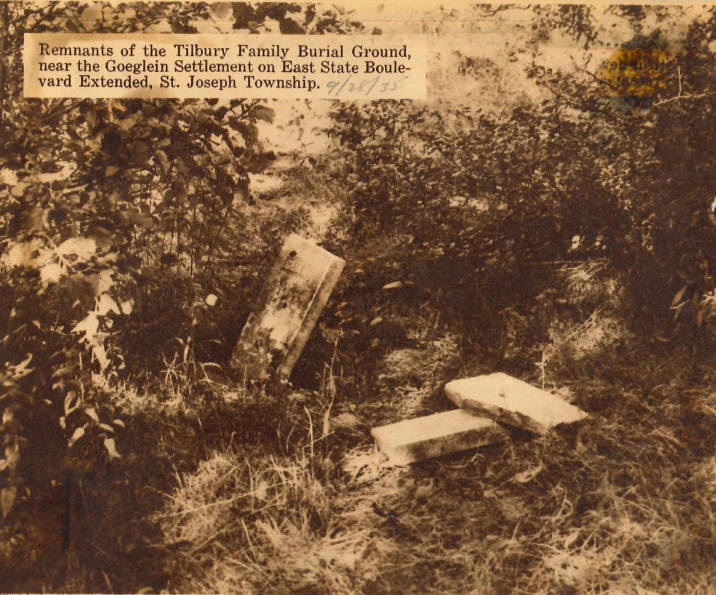
Nathan and Margaret Tilbury gravestone is barely visible near a tree in this Street View photo from Google maps

Earliest date 1852. No longer used and no records. By 1979 only one tombstone of the eight known burials, from the 1932 NSDAR cemetery reading, remains for Margaret and Nathan Tilbury.

In the March 2013 Allen County Lines newsletter of the Allen County Genealogical Society of Indiana on page 65-66, Kathryn Bloom researched Nathan's family discovering he was a Civil War veteran with several children in his family. John Tilbury owned a 110 acre farm purchased in 1833. The Tilbury Farm at 1928 Reed Road in 1996 was designated by ARCH ( Architecture and Community Heritage) a Fort Wayne Local Historic District. See our section on Historic Places.

  1. NSDAR tombstone photos
  2. Find-A-Grave 25 memorials
  3. Allen INGenWeb Google map

SHAARD Indiana State Historic Architectural and Archaeological Research Database (SHAARD)

  1. Survey Number CR-02-19
  2. Latitude 41.0901 Longitude 85.0788.
  3. Established 1852, most recent burial 1979, 2 stones
  4. Tilbury.pdf map of location
  5. 02-19 survey form.pdf little remains
  1. There are several Tilbury's mentioned in the online book The pictorial history of Fort Wayne, Indiana : a review of two centuries of occupation of the region about the head of the Maumee River Volume 1 by Griswold, B. J. (Bert Joseph), 1873-1927; Taylor, Samuel R., Mrs, Publication date: 1917 on Archive.org.
  2. Nearly 200 comments to an April 16, 2023 discussion of the Tilbury farm by the new owner of the home on True Fort Wayne Indiana History on Facebook.

    One comment is from a Tilbury descendant who has researched the family, farm, and cemetery.

    Another comment showed three gravestones in a photo dated 9/28/1935 captioned: Remnants of the Tilbury Family Burial Ground, near the Goeglein Settlement on East State Boulevard Extended in St. Joseph Township labeled Tilbury Family burial ground, East State Boulevard, St. Joseph Township, IN at the Allen County Public Library Digital Collections at the Allen County Public Library.

  3. April 16, 2023 post to True Fort Wayne Indiana History on Facebook with almost 200 comments included one that shared this article: 1996 - Tilbury Farmstead - Lasting Landmark Fully intact farmstead awaits historic status about the Tilbury farm in The Daily Journal 29 June 1996, Saturday, page 30 Franklin, Indiana on Newspapers.com.

    Photo caption: Above, Elwood Zimmerman stands outside his barn on the only intact farmstead within Fort Wayne city limits. Above right, this is a copy of a circa 1898 photo of the Tilbury farmstead on Reed Road in Fort Wayne.

    LASTING LANDMARK Fully intact farmstead awaits approval of historic status 4 By Andrew Jarosh the associated press FORT WAYNE It's hard to envision a farmstead still standing in Fort Wayne. But there is one, the Tilbury Farm. The only fully intact farm within the city limits, it has been recommended for local historic landmark status. If approved, the farmstead at 1928 Reed Road, between Nevada and Forest avenues, would join other local landmarks such as. the Embassy Theatre and Trinity Episcopal Church as worthy of "special historic designation. Don Orban, Fort Wayne's historic preservation planner, said the farm is special because it consists of the original brick house and wooden barn, along with a horse stable, in' the same bucolic setting when the- farmstead was built in 1893.. "It's not a working farm," Orban said. "But it's three buildings in a neat row." Ron Murphy, a local real estate agent and member of the local historic preservation organization ARCH, said the farmstead could be saved for future generations in part through the foresight of a California' developer, that is buying the farm and its seven acres for a senior citizens' apartment complex. Murphy said the developer plans to build a three-story complex fronting on Reed Road on about six acres of what was once farmland. The remaining acre, along with the farmstead itself on the northwest corner of the tract, could be donated to a nonprofit organization. Local historic landmark status would protect the exterior of the house, barn and stable from alteration, preserving a chapter from Fort Wayne's history when a. lot of what now is urbanized was at one time wide open farmland. . "There just aren't that many farmhouses like this anymore," Murphy, said. "I'm not aware of anything like this." " .While many intact farmsteads can -be found in rural Allen County, Orban said he believes the Tilbury Farm is the only farmstead completely intact left in Fort Wayne. The buildings that comprise the Tilbury Farm are readily identifiable as a turn-of-the-century farm complex. They represent a rare element within an urban context, and provide a glimpse into the original character of the surrounding area. The area, Orban said, didn't really become urbanized until the late 1950s. The house itself is an unusually large and elaborate example of a Queen Anne farmhouse, the only notable example of a Queen Anne farmhouse in northeast Fort Wayne tosurvive with outbuildings. Because of its size and high style, the Tilbury house was likely used as a landmark from the time of construction and, as later residential construction developed on the surrounding land, the house and outbuildings have remained an important visual feature in the area, according to local historic preservation officials. The property was bought by Jasper and Florence Tilbury in 1892. The buildings that make up the Tilbury Farm today consist of a house and barn, both built in 1893, and a small stable, built in 1950. The large, two-story brick house has a steep, cross-gabled roof that features decorated verge boards, open eaves and a square tower with a concavely curved cornice. In 1925, a Craftsman-style brick front porch was added and serves as both the main entry and the front entry into the kitchen. A low, one-room gabled frame addition with a brick base extends from the north side of the house. The 2,600-square-foot house has a full basement, six bedrooms, two baths, a big country-style kitchen, a huge dining room and a formal parlor. There's a third-floor tower; however, there is no access to it. To the north of the house, the small, English barn has been altered on the first floor to be used as a garage. But the original character with pegged timber-frame construction, loft and vertical wood siding remains intact. If put on the market, Murphy estimates the farmstead would be worth $150,000. Elwood and Betty Zimmermann have lived there 38 years, raising four children. "We've enjoyed the place tremendously," Elwood Zimmermann said.

TRIER Family Cemetery

Section 20  of the 1898 Standard Atlas of Allen County, Indiana
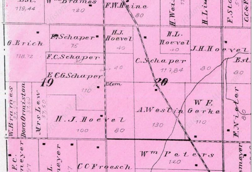
Section 20 of the 1898 Standard Atlas of Allen County, Indiana by Geo. A Ogle

Southeast side of Fort Wayne, was located on the H. J. Hoevel land on the east side of Hessen Cassel Road, half way between Hoevel Road, now McKinnie Road, and Paulding Road shown on the 1898 Atlas of Adams Township in the NW corner of the SW Quarter of Section 20 (thanks to Mike Fromholt). 4 tombstones were in German. Earliest date April 24, 1842. No longer exists, no records.

  1. Allen INGenWeb Google map
  2. NSDAR 1932 transcription

SHAARD Indiana State Historic Architectural and Archaeological Research Database (SHAARD)

  1. Survey Number CR-02-20
  2. Section 20, Township 30, Range 13E. Most recent burial 1871
  3. 02-20 survey form.pdf exact location unknown

Trinity Evangelical Lutheran Cemetery

7821 Decatur Road, Street View photo from Google Maps

South of Tillman Road, on the east side of Old Decatur Road.

Early German settlers. Earliest burial date January 4, 1864. Still in use.

  1. Allen INGenWeb map
  2. BillionGraves nearly 200 records
  3. Find-A-Grave over 350 memorials
  4. NSDAR tombstone photos

SHAARD Indiana State Historic Architectural and Archaeological Research Database (SHAARD)

  1. Survey Number CR-02-21
  2. IN DNR Latitude 41.0139 Longitude 85.1086.
  3. German, Lutheran, established 1852, first burial 1864.
  4. Trinity.pdf five pages of maps
  5. 003-214-26229.pdf cemetery sections one page drawing
  6. 02-21 survey form.pdf Cemetery Registry Survey Form
Back to top

Page updated: April 16, 2024