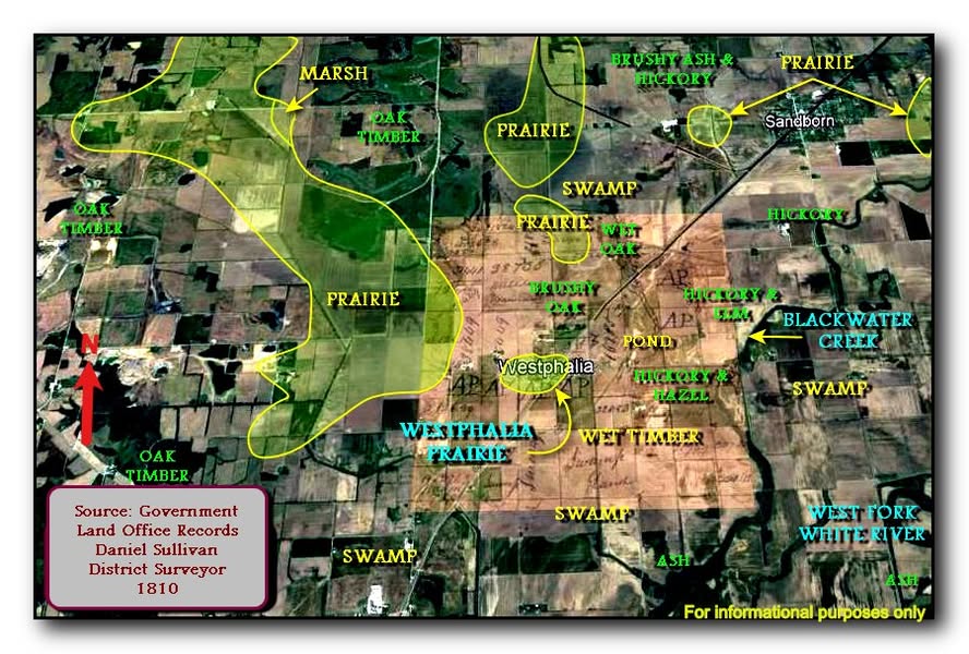
Physiographic regions example using historical records and modern technology overlaid onto modern map for Knox County, Indiana. If you find or create a map showing former forests, prairies, swamps, wetlands like this for Allen County, please Contact Allen INGenWeb.
I believe I posted a version of this quite some time ago. This is part of a project I have been working on to create a series of very detailed maps of Knox County by taking the data from Government Land Office (GLO) plats and surveyor’s notes and overlaying and georeferencing the plats to current Google Earth images. I am using this along with soil data, geology/geomorphology, topographic data, and historical references to determine the distribution of small wet prairie/grasslands vs timber, swamp, barrens etc. in portions of the county. The original purpose was to combine this with historical accounts of the territorial period to create a detailed model of the landscape of the Vincennes area during the time when the events occurred. But I am also using it to provide general information on what native plant species may have been on and around this property and the nature of these small prairie patches that had a large percentage of edge environment. I can use this for my native habit creation that is ongoing. The tan square in the middle of the image is the overlay of the 1810 GLO plat map covering the Westphalia Prairie area. Yeah….. you're right! I need to get out more and have a life!
Description: In the Treaty of St. Mary's of 1818, the Miami Indians ceded their claim to a large amount of land to the United States and in 1823 the federal government agreed to open a land office in Fort Wayne and allow the city to be platted. This "Original Plat" of 118 lots over 109 acres became the basis of the emerging town. Bounded by the present streets of Barr, Washington, Superior, and the alley between Calhoun and Harrison, the streets were laid out parallel to Columbia Street-not in a true east-west compass direction. The plat also included a public square with Court Street as its eastern boundary. With the exception of Water Street, which has since been changed to Superior, the streets in the Original Plat retain the names given them in 1823. [ See Streets of Fort Wayne ]
The opening of the land office in 1823 had a significant effect on the town's pioneer settlement, al-lowing the public to buy the ceded Miami land. By May 1824, the Original Plat of the city was complete. The city's platting brought forward men who were adventurous entrepreneurs and developers. Sales at the land office boomed, especially after 1835, when there was a surge in land values. Fort Wayne began to grow as additions to the town adjoining the original plat were laid out by early land developers such as Cyrus Taber, Samuel Hanna, the Ewing Family, and William Rockhill.
Land surveying is the technique, profession, art, and science of determining the three-dimensional positions of terrestrial points and the distances and angles between them. These points are usually on the surface of the Earth, and they are often used to establish maps and boundaries for ownership, locations, such as the designed positions of structural components for construction or the surface location of subsurface features, or other purposes required by government or civil law, such as property sales. Surveying has been used by man since the beginning of recorded history. The planning and execution of most forms of construction require it. It is also used in transport, communications, mapping, and the definition of legal boundaries for land ownership. To map the territory in preparation for the creation of Allen County, surveyors used tools like theodolites, a tool like a telescope used to measure angles, and chains and rods, tools for measuring distance. The original surveying of the area that would become Allen County, Indiana began in the 1820s and continued throughout its townships until the 1840s. Mapping the landscape allowed for new areas to be better understood, opening the door to buy and sell land and to build the new community we call home. #sociallyhistory
How to measure land area using your phone 2022 Link...
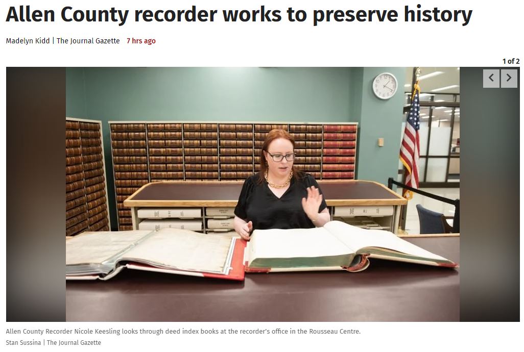
Deed transfers and township plots can be traced back centuries through the Allen County recorder’s office, but preserving the books that hold them is important for more than the history they contain.
State law requires county recorders to preserve the records of deeds – signed legal documents typically involving property ownership or legal rights – and mortgage agreements. The oldest deed residing in the Allen County recorder’s office is from 1873.
Allen County Recorder Nicole Keesling said the local office has been sending books containing documents to a company to be treated and rebound since 2017, when former Recorder Anita Mather pushed for the project. The pages and ink on the documents have deteriorated because of age and oils from hands over time.
“This is something that I have to do statutorily as a preservation of the records,” she said. “They’re permanent. Digital is not considered a permanent format yet, so that is why we still microfilm everything – and it’s getting harder.”
The Allen County Recorder's Office website states: There are nearly 163,000 parcels of land in Allen County. Those parcels represent the single biggest investment most people will ever make – their homes and businesses. The Allen County Recorder’s primary function is to maintain permanent public records of the transactions that convey property from one owner to the next. We have a passion for public service and are always happy to go above and beyond to answer all questions that we are able to regarding property ownership records and recordings.https://www.allencountyrecorder.us/.
It's #ManuscriptMonday! Land records are a goldmine for your family history research. They pinpoint your ancestors' homes, trace their journeys, validate family ties, unveil the historical landscape, and offer many more insights. Dive into "Locating Your Roots: Discover Your Ancestors Using Land Records" by Patricia Law Hatcher.
The Allen County, Indiana Deed Index at the Allen County Genealogical Society of Indiana website has links to names of Grantor - Grantee images with property description, book volume and page number as a work in progress. Property descriptions include the Section, Township and Range described in various links below.
Our Fort Wayne City Directories page has online ebooks from 1858 through 1923 and a few years after that listing names, addresses, and additional information for city and county families, businesses, churches, schools and more.
Starting in 1833- nearly 200 years ago- the federal government sent land surveyors to mark out the counties, one square mile after the other, including Allen County.
From the article:
The Public Land Survey was the federal government’s plan to sell land and generate property taxes to pay off heavy war debt.
Hardy men on horseback laid out cornerstones in one-mile squares called sections, work that continued more than 50 years and was documented on large paper vellums. These vellums are kept in leather-bound ledgers at the surveyor’s office that look more like they belong in a Harry Potter movie.
Names like Beaubien, Richardville, Didier, Wells, De Rome, Hackley, Perry, Rudisill and Barnett populate the vellums, still used today for reference. They reflect the French and English beginnings of the town that went on to include German, Irish and other settlers whose stakes jostled with many tribal reserves. Fort Wayne earlier was known as Kekionga and Fort Miami.
The county’s future expansion was pretty much assured with the opening of the Wabash and Erie Canal in 1832.
Fort Wayne had been incorporated in 1829 with just 300 people. The town sat in the midst of land that was mostly swamps and forests with three rivers we know now as the St. Marys, St. Joseph and Maumee, Allen County Surveyor Mike Fruchey said. By 1840, the population had swelled to 2,000, according to online sources.
When Fruchey took over the surveyor’s office a year ago, he made it his mission to tackle the state’s Section Corner Perpetuation project until every cornerstone is documented. Their importance can’t be minimized, Fruchey added.
Cornerstones are the basis for property surveys and disputes, land transfers, new home construction, property assessments and infrastructure. GIS, or Geographical Information System, is based on these cornerstones, as is the emergency 911 system.
Allen County’s cornerstones are still there, four per square mile with four half-mile markers. Each township has 36 sections, except for a couple like Scipio that are smaller, Fruchey said.
The last time there was an effort to locate the estimated 2,400 cornerstones in the county was more than 20 years ago. Fruchey says slightly fewer than 1,400 have been found.
For "Throwback Thursday" we share this article written by The Legendary Columnist Cliff Milnor of the Fort Wayne Journal Gazette and printed on March 30, 1968! As Cliff says "Who needs a surveyor?"
A certain tract of land lying and being in Breathitt County, KY, on the waters of Troublesome Creek, and more particularly bounded and described as follows, to-wit:
Beginning at stone marked X at the corner of Ged Strong's poultry lot; thence running with poultry lot to the corner of garden; thence with garden fence to lower end of garden, thence to a plum tree near a light pole; thence to corner to Chester Stacy's lot; thence up the drain with Stacy's line to lot to the lower side of the road leading to Ged Strong's house; thence with said road and fence to the beginning. Containing eight (8) acres, more or less.
Lineage Research Using Land Records by Indiana Genealogical Society, Inc. April 3, 2023
on YouTube
Apr 3, 2023 #familyhistory#genealogy#landrecords. This was an IGS Facebook Live Event from March 2022. Diana Brumfield to discuss lineage research using land records. As a knowledgeable genealogist and experienced researcher, Diana has a wealth of experience using land records to trace family histories and connect with ancestors. Join us for this informative conversation as we delve into the fascinating world of lineage research using land records! The Indiana Genealogical Society is proud to host the IGS Facebook Live events, which are held on the first Tuesday of every month. For updates on our upcoming events, please visit our Facebook page at @indianagensoc. And if you have ancestors from Indiana, be sure to check out our website at www.indgensoc.org for more resources and information on how to connect with your Hoosier roots.
#familyhistory#lineage#landrecords#genealogy#genealogyresearch
Rectangular Survey System used in Indiana
Section, Township, Range referenced on land deeds and legal descriptions
Indiana survey records are now published to the GLO site! 📜 This site provides live access to federal land conveyance...
Indiana survey records are now published to the GLO site!
This site provides live access to federal land conveyance records for the Public Land States, including image access to more than 12 million federal land title records issued between 1788 and the present.
Fort Wayne Land Office Entries, 1823-1852 information at the Indiana Archives and Records Administration at IN.gov. This is a brief introduction to the Fort Wayne Land Office Database, compiled by the Archives' staff with the aid of an Indiana Heritage Research Grant. The "land office business" in Indiana began in 1801, when public lands in the southeastern corner of the Indiana Territory were put up for sale at Cincinnati. The U.S. Congress subsequently opened land offices at Vincennes in 1804; at Jeffersonville in 1807; in 1819 at Terre Haute (later Crawfordsville) and Brookville (later Indianapolis); and at Ft. Wayne in 1822. The Fort Wayne District embraced all or part of the present counties of Adams, Allen, Blackford, Cass, Clinton, DeKalb, Delaware, Grant, Howard, huntington, Jay, Kosciusko, Lagrange, Madison, Miami, Noble, Randolph, Steuben, Tipton, Wabash, Wells, and Whitley. The first sale of land at Fort Wayne took place on 22 October 1823. Receipt No. 1 went to William Willson, of Middletown, Ohio, for 93.30 acres just east of Fort Wayne at the bend of the Maumee River. After the Fort Wayne Land Office closed on 21 February 1852, its records were transferred to the State Auditor and from there to the Indiana State Archives. The first land entry was discussed October 22, 2022 on True Fort Wayne Indiana History on Facebook.
Maintain permanent public records involving a wide
variety of instruments involving real estate,
mining, personal property, mortgages, liens,
leases, subdivision plats, military
discharges, personal bonds, etc. From 2007 Guide to Indiana County Government.
The County Recorder's function is to maintain permanent public records involving a wide variety of instruments. These documents detail transactions involving real estate, mining, personal property, mortgages, liens, leases, subdivision plats, military discharges, personal bonds, etc. Quote from their What Does the Allen County Recorder Do? webpage.
Q.) Do you have an online searchable database for recorded deeds and other information?
A.) Yes! Data and documents going back to January 1970 can be viewed online.
The Allen County Recorder's Office offers online access to data and documents from Jan. 1, 1970, to present. Certain records prior to 1970 are also available online. New documents usually appear online within 24 hours of recording. We currently offer more than 3 million documents online.
Property owners or other parties looking for copies of their land records often ask us what proof they need to have in order to obtain those records. The answer is simple: Nothing. In Indiana, land records are public records. You may obtain copies of these documents without having to prove ownership (or anything else).
While most people think land records when they deal with the Recorder's Office, we safeguard a multitude of other records as well. Many people also record out of state or international birth and marriage records. Since certified copies are often accepted as originals, it is far easier to retrieve such documents from a Recorder's Office than from the state or country they came from.
We get many calls from property owners looking for copies of their land surveys. Our response, more often than not, is disappointing. Why? Surveys are very rarely recorded, since they are not a required part of the process of transferring ownership. The owner may record the survey, but it's not mandatory in most cases. That's why so few surveys appear in our records.
Copies of land records are at the Allen County Recorder's Office for $1 a page if you copy in person. To search online: go to www.landrecords.net, find Allen County in the pull down menus under “Search Now” and search by the document number. There is a search fee involved, but the price is still most likely less than the value of your time and the cost of a trip downtown. From a June 3, 2014 post on Allen County Recorder's Office on Facebook.
Searching Allen County Recorder's Office Records Online explains what records are available and how to search records at the Allen Country Recorder's Office. They have an online Allen County's GIS Portal aka iMap, Intelligence Mapping, Geospatial Information Systems (GIS), with maps and aerial photos taken over various years for Allen County Property. An April 11, 2018 program Using GIS to Find Ancestral Homes by John Schreiber presented by the ACGSI has additional information to links on our site and photos of the program. Our Maps page has a 42-minute video on the GIS mapping portal.
I Paid Off My Mortgage. Where's My Deed?When you pay off a mortgage, either through refinancing or paying off your home, the bank records a document, called a "release of mortgage," reflecting that milestone. Copied from a March 13, 2021 Allen County Recorder's Office Note on Facebook.
January 8, 2015 post by Hofer and Davis, Inc. Land Surveyors on Facebook:
In regard to our "Plat of the Week" one of our friends Kurt Luebke, a Land Surveyor in Montana and originally from Fort Wayne and a fellow Concordia High School graduate, was inquiring about gaining access to these plats.
If anyone is interested visit www.allencountyrecorder.us then click the NEIGHBORHOOD RESOURCE CENTER, then click Search Restrictive Covenants Online, then enter the name of the subdivision and click search, find the subdivision you want and double click that plat, then click the view image, and the plat will come up. Good Luck!
The Blackford, DeKalb, Grant, Jay, and Wells County Recorders joined Allen County Recorder Nicole Keesling yesterday for a press conference hosted by the Indiana Recorders Association to talk about the importance of Property Fraud Protection!
*********
The job of the Allen County Recorder’s Office is to maintain all county property records. We record documents, mainly deeds but also mortgages, release of mortgages, land contracts and liens. We also record a few miscellaneous records such as DD214s (military discharges), sole proprietor business names and out-of-country marriage licenses. We keep digital copies of all records, and still microfilm them to maintain them permanently. By law, we can record anything if it meets our recording requirements, including being notarized. Copied from For the record: County office responsible for documents also helps residents with fraud detection Nicole Keesling Jan 27, 2024 The Journal Gazette newspaper
Indiana Land Records
Allen County Surveyor Mike Fruchey said the federal government placed 2,400 cornerstone markers throughout Allen County to establish property lines in the early 1800s. So far, the county has located 1,357 underground stones. Fruchey said property line records show where the markers should be, but the stones can be moved or destroyed by development projects. State statute requires counties to find and maintain at least 5% of the county’s total stones each year. The same Allen County employees have been doing the work for at least 15 years, Fruchey said, but the state hasn’t counted their work for five years because a land surveyor hasn’t overseen it. “All property lines are based off of them, so your taxes are based on your acreages, which are based off these original stones that the federal government placed,” Fruchey said. “This is just the beginning of that process.” Copied from County to relocate, reestablish property line corner stone markers by Devan Filchak published Augsust 27, 2022 in The Journal Gazette newspaper.
Land Records at the Indiana State Archives The State Archives contains a wide variety of land records. As Indiana was a public domain state, virtually every acre was surveyed and then sold or otherwise granted by the federal government before settlement. The only exceptions are the lands around Vincennes settled by the French and George Rogers Clark's Grant around Clarksville. For all of Indiana, these land records exist: field notes - the surveyor's written description; plat maps - the surveyor's graphic description; and land office tract book entries - the accounts of individual purchases. All of these are available for examination at the State Archives. The compiled land survey notes have also been digitized and are available online from the National Archives.
A new land office opened at Fort Wayne in 1823. It sold lands in all or part of the present day counties of Adams, Allen, Blackford, Cass, Clinton, DeKalb, Delaware, Grant, Howard, Huntington, Jay, Kosciusko, Lagrange, Madison, Miami, Noble, Randolph, Steuben, Tipton, Wabash, Wells, and Whitley. The final sales were in 1852; all lands remaining unsold were attached to the Indianapolis Land Office.
The tract book records for Fort Wayne are available on the Indiana Digital Archives and contain the complete land description. These early land records enhance the Bureau of Land Management's Land Patent database by providing the date of purchase rather than the date the land patent was issued. This invaluable tool will often place early settlers on their land earlier than the patent date.
The Fort Wayne District embraced all or part of the present counties of Adams, Allen, Blackford, Cass, Clinton, DeKalb, Delaware, Grant, Howard, Huntington, Jay, Kosciusko, Lagrange, Madison, Miami, Noble, Randolph, Steuben, Tipton, Wabash, Wells, and Whitley.
Hoosier Homestead at IN.gov. The page states: In honor of Indiana's rich agricultural heritage, the Hoosier Homestead Award Program recognizes families with farms that have been owned by the same family for 100 years or more. The program was instituted in 1976 and recognizes the contributions these family farms have made to the economic, cultural and social advancements of Indiana. In the past 45 years, more than 5,800 farms have received the honor. There are two Hoosier Homestead Ceremonies each year: one is at the Indiana State Museum in March (2021) and the other is during the State Fair in August. Indiana family farms may qualify for the following: Centennial Award - 100 years of ownership; Sesquicentennial Award - 150 years of ownership; Bicentennial Award - 200 years of ownership. Winners are listed by years beginning in 2011 on the Hoosier Homestead page.
Previous Hoosier Homestead Ceremonies under ISDA have been archived: A database of previous recipients can be found in the Hoosier Homestead Award Database.
A comprehensive list of Hoosier Homestead Recipients from 1976-2014 organized by county can be found here.
Plat book of Allen County, Indiana (1900) - Lindemuth, C. Ross, Photocopy of original edition, maps only (advertisements omitted), definitely one of the more useful books for genealogy purposes!
Property Deed Scam - Indiana Attorney General warning about a scam to sell copies of deeds. As public records deeds only cost $1-2 for actual copy costs.
Land Records Indiana State Archives Land Office Database: https://secure.in.gov/apps/icpr/search/ [formerly http://www.indianadigitalarchives.org/default.aspx] Indiana State Archives holds field notes and original plats made by federal surveyors and land office tract books recording individual purchases from the federal land office. Of the six federal land offices in Indiana, the tract book records of three, Ft. Wayne, Vincennes, and LaPorte-Winamac, are online. Patrons can search abbreviated versions of these and can contact the Archives for the full record. Note: All subsequent private transactions and plat maps are held by the county recorder.
Home on the Range: Introducing U.S. Federal Land Records
From 1785 to 1934, the U.S. Government sold more than 5 million acres of land to hundreds of thousands of citizens, including some of your ancestors. Come learn about the laws, the survey system, and the records created by the sale of Federal Land in the United States.
Before the BLM, there was … the General Land Office.
Created in 1812, the GLO was responsible for public domain in the U.S. It was placed under the Dept. of the Interior in 1849 & was merged with the U.S. Grazing Service to become the agency we know today in 1946! pic.twitter.com/n40VWTRguW
Before the BLM, there was … the General Land Office.
Created in 1812, the GLO was responsible for public domain in the U.S. It was placed under the Dept. of the Interior in 1849 & was merged with the U.S. Grazing Service to become the agency we know today in 1946!
Happy Birthday to the Library! Yesterday was the Library's 225th birthday, founded in 1800🥳Here is a map of the Capitol grounds from that year where the Library was housed until the Jefferson Building was constructed almost 100 years later.
Happy Birthday to the Library! Yesterday was the Library's 225th birthday, founded in 1800Here is a map of the Capitol grounds from that year where the Library was housed until the Jefferson Building was constructed almost 100 years later.
Tracing the Trails of Your Ancestors Using Deed Records December 6, 2012 William Dollarhide on GenealogyBlog.com demonstrates the power of deeds in retracing the trail of an ancestor. His real example uses deeds to solve a difficult genealogical problem. If you know that an ancestor was from Virginia, but do not know in which county he lived, then his example may give you an idea of how deeds can help you locate the right county.
An event November 15, 2022 by the U.S. Forest Service - Hoosier National Forest and Lawrence County Soil & Water Conservation District on Facebook. Description: Presented by AJ Ariens, Forest Archaeologist with the Indiana Department of Natural Resources (DNR). Join us Tuesday, Nov. 15, at the Otis Park Bath House to learn what the first men who surveyed the Indiana Territory in the early 1800s said in their notes about the land that they found. You may be surprised at what trees they selected as witness trees and what notes they made. AJ Ariens has studied the notes made over 200 years ago by these men and will share what she’s learned about the lands they surveyed in the early 1800s. Hosted in collaboration with Bedford Parks Department, Purdue University Extension, USDA Natural Resources Conservation Service, Lawrence County Soil & Water Conservation District, and Indiana Department of Natural Resources. Posted October 24, 2022 by U.S. Forest Service - Hoosier National Forest on Facebook.
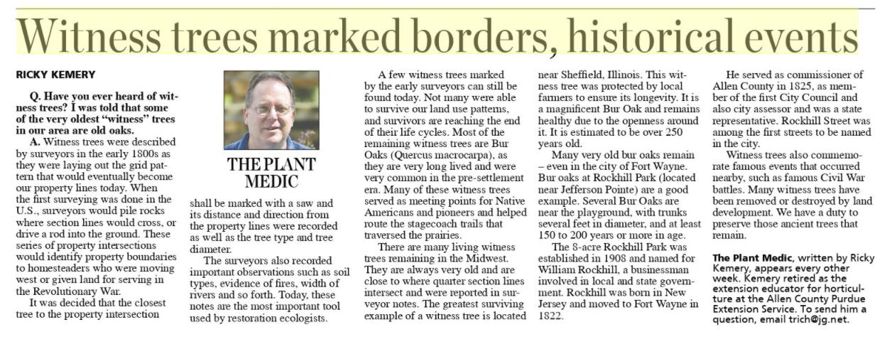
Witness trees were described by surveyors in the early 1800s as they were laying out the grid pattern that would eventually become our property lines today. When the first surveying was done in the U.S., surveyors would pile rocks where section lines would cross, or drive a rod into the ground. These series of property intersections would identify property boundaries to homesteaders who were moving west or given land for serving in the Revolutionary War.
It was decided that the closest tree to the property intersection shall be marked with a saw and its distance and direction from the property lines were recorded as well as the tree type and tree diameter.Witness trees marked borders, historical events Ricky Kemery, March 1, 2022 The Journal Gazette newspaper.
The headlines could have read, "Almost One Quarter Million Acres of Virgin Forestland Cleared Annually", or "18 Million Acres of Virgin Forestland Denuded in Just 80 Years!'
These are not today's newspaper headlines of a South American country or emerging third world country, but instead could have been the lead story for the Indianapolis News some time around the turn of the century.
At the time of European settlement in Indiana, about 90% (approximately 20 million acres) of the land base was forested. Early explorers to our state talked about traveling for days under a continuous canopy of trees broken occasionally where a tree or trees had fallen. Even when Indiana received statehood in 1816, it was still almost entirely forested.
By the early 1900's, however, this pristine picture of Indiana changed dramatically! Charles Deam, Indiana State Forester noted in the 1922 Department of Conservation Annual Report "Indiana contains 22,402,502 acres. The yearbook of Indiana for 1917 credits the state with 1,664,886 acres of timberland. This area had shrunk in 1920 to 1,387,248 acres- an average annual decrease of 92,456 acres. Our area of timber in 1920 was a little over 6% of our area. Deam went on to say that at the present rate of clearing, Indiana would be treeless in 15 years. Something had to be done!
It is interesting to note that up until 1920, all land was taxed at the same rate. It did not matter if the property was identified as cropland, wasteland, woodland, pasture, or swamp, it was alt taxed the same. Property owners were almost forced into cutting their forests to convert them to either cropland or pasture.
By 1920, there was a movement afoot to develop a means to encourage woodland owners to keep their land in trees. In 1921, the Indiana legislature passed the Indiana Forest Classification Act (I.C. 6-1, 1-6). This Act encouraged proper timber management and watershed protection on private forests. The incentive for landowners to enroll their lands in the program was a reduction in property taxes. Property taxes on qualifying land was determined by assessing the land at $1.00 per acre then applying the county tax rate resulting in a 90% or more tax reduction.
The program requires that the eligible area be at least 10.0 contiguous forested acres. Woodlands may be either native forests containing at least 40 square feet of basal area per acre, or at least 1,000 timber producing trees (any size), per acre. Tree plantations with at least 300 well-established timber producing trees are eligible to be a Classified Forest. Copied from a longer article on WoodlandSteward blog at Indiana Woodland Stewart.
Hoosiers and the American StoryDesigned for middle and high school learners, the adventures in Hoosiers and the American Story by James H. Madison and Lee Ann Sandweiss are written to stimulate dialogue. Each chapter begins with an overview highlighting main themes in American history and connects to the Indiana stories that follow. The four case studies in each chapter about individuals who have shaped our state in interesting ways and everyday people and their experiences. by the Indiana Historical Society . Hoosiers and the American Story 360 pages or individual chapters below:

 Here is a map of the Capitol grounds from that year where the Library was housed until the Jefferson Building was constructed almost 100 years later.