On this day in 1827 congress granted land for the construction of the Wabash and Erie Canal. This canal was a joint undertaking by Indiana, Ohio and the federal government. Construction started in Fort Wayne, Indiana, and spread in both directions. Pictured here is a wedding party on the canal in Attica, Indiana in 1872.
Where was the Wabash & Erie Canal in Allen County, Indiana?
Want to explore the Wabash & Erie Canal? You have to find it first, and that can be a challenge! Read about it on our blog: Hidden Highway: Where’s the Canal?
In our 24/7/365 modern world imagine if weather shut it all down for months at a time. Easy to understand why canals didn't last once people learned we could build things to move lots of things faster than walking. We wanted it year around and once railroads came along they rarely stop because of the weather.
And the last batch of photos. This time of the canal and surrounding area in winter. ❄❄❄ #miamicountyohio #johnstonfarmohio #johnstonfarm #historichouse #19thcenturyhistory #historichouses #piquaohio
Page 362CHAPTER XXIX— 1843. The Great Canal Celebration — General Cass's Address. The canal is opened between Toledo and Lafayette — The memorable Fourth of July, 1843 — Commodore Perry's cannon booms a welcome to the visitors— The Toledo Guards — The parade — The exercises at the Swinney farm, now Swinney park — General Cass's address — Peter Kiser and the barbecue — The toasts — General Cass receives a "ducking" — Promoters of the celebration — The packets and the freight boats — Early boat owners — Passenger and freight rates — Henry Lotz, mayor — The first daily mail — Highway building — The first daguerreotypes — "Johnnie Appleseed."
The Wabash and Erie Canal officially opened in Northeast Indiana in July of 1843. The festivities began on the 4th of July with the firing of the Perry Cannon. During the celebrations General Lewis Cass gave a speech praising the canal:
"We have come here to rejoice together. Memorable deeds make memorable days. There is a power of association given to man, which binds together the past and the present, and connects both with the future. Great events hallow the sites where they pass. Their returning anniversaries, so long as these were remembered, are kept with sorrow or joy as they are prosperous or adverse. Today a new work is born, a work of peace, not of war. We are celebrating a triumph of art and not of arms. Centuries hence, we may hope the river you have made will flow both east and west, bearing upon its bosom the riches of a prosperous people, and that our descendants will come to keep the day which we have come to mark; and that as it returns they will remember the exertions of their ancestors while they gather the harvest."
The Perry Cannon came from a British ship engaged at the Battle of Lake Erie during the War of 1812. Following the war it was brought to Fort Wayne. The cannon eventually became a hitching post in front of the Franklin Randall home at the northeast corner of Lafayette and Berry streets, as evidenced by an image in the 1880 Allen County Atlas. In 1916 the cannon was given to the City of Fort Wayne, who donated it to the Historical Society in 1960. Today it guards the front entrance to the History Center.#sociallyhistory
National political campaigning came to Fort Wayne in 1843 when the great Wabash and Erie Canal was inaugurated.
July 4 was the day chosen for dedicating the canal, then open from Toledo to Lafayette. Picnics, barbecues and parades were planned, and letters of congratulations poured in, most notably from such great men of the day as Daniel Webster, President Martin Van Buren, Henry Clay and Gen. Winfield Scott. But the highlight of the doings in Fort Wayne was the appearance of Gen. Lewis Cass, the main speaker and Democratic candidate for the 1844 presidential ticket.
Cass was a Westerner and knew well how to stir fellow frontiersmen with sonorous speeches. Cass was a very large man in every respect. A notable commander in the War of 1812 and the Indian campaigns afterward, he was military governor of Michigan Territory from 1813 to 1831.
Scores of canal boats from every Midwestern port were gaily festooned and tied three deep along the shore and docks of Columbia Street. Cass arrived by canal boat that morning, and before hundreds of well-wishers gathered along the banks he started to cross the gangplank to shore when a local poet began to hold forth with some grandiloquent verse in honor of the general. Cass, his eyes set on the poet, stepped right off the gangplank and into the fetid waters of the canal.
Undaunted, Cass dried off at Allen Hamilton's home on Lewis Street, and attended the afternoon activities at the Swinney Homestead.
The crowd, gathered there in the thousands, thoroughly enjoyed his two-hour address - even those who could not hear the general, for they were content to cheer at the frequent firing of the old cannon taken from a British ship in the War of 1812. Today, this cannon stands at the entrance to Historic Fort Wayne. Still, it is said, the humiliation of his canal dunking haunted Cass' candidacy and had a hand in his failure to gain the Democratic nomination. Cass, however, was the party's nominee in the election of 1848, but went down to defeat against Mexican War hero Zachary Taylor of the Whig Party.
In the early 1800s, Indiana dreamed of connecting Lake Erie with the Ohio River via the Wabash and Maumee Rivers. In 1827 the federal government financed Indiana's first major canal project, the Wabash and Erie Canal.
Work began on the project in the Fort Wayne area in 1832 and moved downstream along the Wabash River. Jesse L. Williams, the chief engineer, supervised skilled artisans who built locks, culverts, and aqueducts. More than a thousand laborers, many of them Irish immigrants, performed the backbreaking work of moving dirt with pickaxes and shovels.
The opening of the Wabash and Erie Canal as far south A Huntington was marked on July 4, 1835, with a grand celebration of speeches and toasts. Canal mania spread throughout the state!
Today there still is canal mania as the Wabash & Erie Canal Park has an endorsed bicentennial Legacy Project that celebrates and honors Indiana's rich canal history.
This outstanding Queen Anne shingle style house on West Dewald Street was built in 1910. It has its original wood siding...
This outstanding Queen Anne shingle style house on West Dewald Street was built in 1910. It has its original wood siding and windows, and its chimney has fluted brick with a circle pattern. Its block was platted by Jesse L. Williams in 1884. Williams was better known as a canal engineer than as a real estate developer. He was Chief Engineer on canal projects in Ohio and Indiana. After working in Ohio, he was appointed in 1832 as Chief Engineer of the Wabash and Erie Canal project starting in Fort Wayne. He went on to work for the US government to identify the correct grade for the cross-continental railroad system over the Rocky Mountains, saving the project huge amounts on construction costs. ARCH is proud to present this edition of Throwback Thursday, part of its work as the historic preservation organization serving the greater Fort Wayne area, made possible by ARCH members and donors. Thank you.
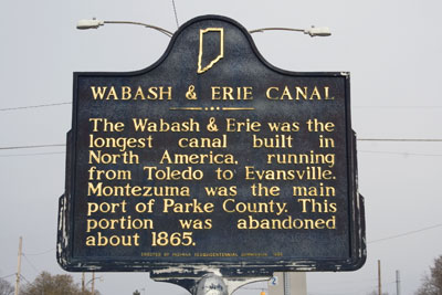
On March 2, 1827, Congress provided a land grant to encourage Indiana to build the Wabash & Erie Canal. The original plan was to link the navigable water of the Maumee with the Wabash through the seven mile portage at Fort Wayne. Work began five years later on February 22, 1832, in Fort Wayne. Construction proceeded west as the canal reached Huntington by 1835, Logansport in 1838, and Lafayette in 1841. Work was also performed east toward Ohio, but the canal did not open to Toledo until 1843. A second federal land grant enabled the canal to reach Terre Haute by 1849. Copied from Wabash and Erie Canal at IN.gov
February 22, 1832 ground was broken for the canal, which would link Lake Erie at Toledo with the Ohio River at Evansville. Jordan Vigus, Canal Commissioner, Charles W. Ewing, Samuel Hanna, Elias Murray participated in the ceremony. It was completed to Huntington County by July 3, 1835 and by July 4, 1843 was completed near Lafayette, Indiana. It was located where the south end of Headwaters Park is now located. and was replaced a couple of decades later by the growth of the railroads.
Happy groundbreaking day to all who celebrate! 🥳 192 years ago today, construction officially began on the Wabash & Erie...
Happy groundbreaking day to all who celebrate! 192 years ago today, construction officially began on the Wabash & Erie Canal and it was a hot mess by modern standards. Read more on our blog: A Hurried Groundbreaking
When the canal first opened between Fort Wayne, Indiana, and the Wabash River at Huntington, Indiana, in 1835 it was celebrated on July 4th. As the route was extended westward to towns along the line, July 4th was the day usually set aside for the opening honors.
Read more about this, ask questions and contribute your thoughts in the "Discussions" section. HAPPY 4TH OF JULY EVERYONE!
On January 27, 1836, Governor Noah Noble signed the Mammoth Internal Improvements Act, which authorized a $10 million...
On January 27, 1836, Governor Noah Noble signed the Mammoth Internal Improvements Act, which authorized a $10 million loan and provided for three major canal projects, a macadamized road, and a railroad. However, according to historian Kelly Wenig, "After years of crushing debt incurred from loans associated with the 1836 Mammoth Internal Improvements Act, the state finally defaulted on their payments to investors, and continued to do so for the next half decade. Hoosiers—because of their insolvency—were attacked from all angles by angry investors and newspapers from as far away as London."
As a result, exactly 11 years after the Mammoth Internal Improvements Act was signed, the Indiana General Assembly passed the Butler Bill to relieve the state some of the burden of the debt. The bill stipulated that the state would be responsible for half of the $11 million debt, and the other half would be assumed by bondholders, who in exchange for Wabash and Erie Canal stock promised to complete the canal.
On January 27, 1836, Governor Noah Noble signed the Mammoth Internal Improvements Act, which authorized a $10 million loan and provided for three major canal projects, a macadamized road, and a railroad. However, according to historian Kelly Wenig, "After years of crushing debt incurred from loans associated with the 1836 Mammoth Internal Improvements Act, the state finally defaulted on their payments to investors, and continued to do so for the next half decade. Hoosiers—because of their insolvency—were attacked from all angles by angry investors and newspapers from as far away as London."
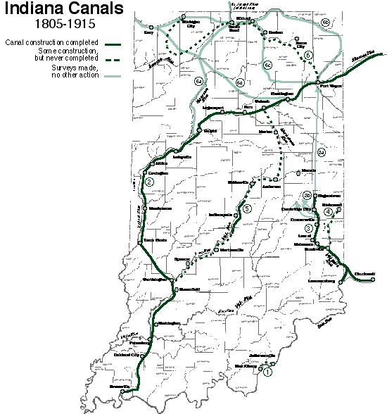
The image below, showing canals in Indiana and Ohio, many of which were constructed under the Mammoth Internal Improvements Act, is courtesy of the Indiana Album.
Work on the Fouts Log House is coming along nicely. Here, you see our MWF crew cut massive timbers from the old lock at Fort Wayne down to size (for replacement logs.) Since then, they have also finished roof preparation for nailing down the cedar shingles. Today, they will begin replacing logs on the lower section of the house.
Correspondence of the Rochester Daily Democrat. Toledo, Jan. 10, 1843.
The Wabash and Erie Canal. The Wabash and Erie Canal will be opened its entire length in the spring. Boats commenced running late this fall from Lafayette, Indiana, a distance of 230 miles to this place. From this city to the junction alone, 66 miles, the canal is 60 feet wide and 6 feet deep. From thence to Fort Wayne, 44 miles, it is 20 feet wide, and from the Fort to Lafayette, 122 miles, 40 feet wide. next spring our Boston or New York friends can reach Logansport, Indiana, by way of the canal in five days after leaving home, or Springfield, the capial of Illinois, in 6 1/2 days.
The Wabash and Erie Canal officially opened in Northeast Indiana in July of 1843. The festivities began on the 4th of July with the firing of the Perry Cannon. During the celebrations General Lewis Cass gave a speech praising the canal:
We have come here to rejoice together. Memorable deeds make memorable days. There is a power of association given to man, which binds together the past and the present, and connects both with the future. Great events hallow the sites where they pass. Their returning anniversaries, so long as these were remembered, are kept with sorrow or joy as they are prosperous or adverse. Today a new work is born, a work of peace, not of war. We are celebrating a triumph of art and not of arms. Centuries hence, we may hope the river you have made will flow both east and west, bearing upon its bosom the riches of a prosperous people, and that our descendants will come to keep the day which we have come to mark; and that as it returns they will remember the exertions of their ancestors while they gather the harvest.
The Perry Cannon came from a British ship engaged at the Battle of Lake Erie during the War of 1812. Following the war it was brought to Fort Wayne. The cannon eventually became a hitching post in front of the Franklin Randall home at the northeast corner of Lafayette and Berry streets, as evidenced by an image in the 1880 Allen County Atlas. In 1916 the cannon was given to the City of Fort Wayne, who donated it to the Historical Society in 1960. Today it guards the front entrance to the History Center. #sociallyhistory
The Landing—and Fort Wayne as a city—only existed because of the Wabash and Erie Canal that ran through it. The last boat was seen on the canal in 1882.
Map of the Wabash and Erie Canal from the Ohio state line to Terre Haute: Showing its course through the public surveys and the area of selection for said work under the acts of Congress of 1824, 1827, 1841 and 1848. From the Indiana State Library Digital Collection where it is zoomable.
Detailed survey map of the Wabash and Erie Canal as it cuts across Indiana from the Ohio state line, through Fort Wayne to Terre Haute. Details such as land sections and names of land grant holders are included. Sheet 1 is from the Ohio State line to just west of Logansport. Sheet 2 continues from that point to Terre Haute. Terre Haute is cut off of the map.
1875 - zoomableMap of Allen County, Indiana, Item ID ISL_IND_MapL_AllenCo_1875, Description:This 1875 detailed map of Allen County, Indiana, was drawn by Samuel Morrison and include railroads, churches, schools, and canals. at the Indiana State Library Digital Collection.
Rotate map to the right to see the Wabash & Erie Canal in this Map of Allen County, 1876, Baskin, Forster and Company, Andreas, A. T. (Alfred Theodore), 1839-1900, Dave Rumsey Map Collection
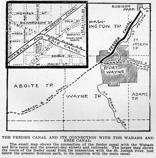
The Wabash & Erie Canal at the summit level in Fort Wayne, IN was supplied with water from the St Joseph River. A dam was constructed on the river and a 6 1/2 mile feeder dug to the main canal line just west of the town. That feeder supplied water for 47 miles east to Defiance, OH and 27 miles to the west to Huntington, IN IN. The signage above marrks the route of that feeder near Beckett's Run
November 9, 2022 post by Wabash & Erie Canal Park on Facebook: This diagram shows the elevation change in the Wabash & Erie Canal from Toledo, Ohio to Evansville. Fort Wayne is the highest elevation on the route (in line "A") [the Summit] and Terre Haute is the lowest elevation (in line "C").
There are many details too small to read here, but hopefully this provides a visual representation of how canals can overcome natural elevation changes while minimizing pesky currents.
A large board of this chart can be found in our interactive museum, which is open Monday-Saturday afternoons 1-4 PM.
This image is identified as the Profile of the Wabash & Erie Canal, Meeks, Thomas & Julia, Anthony Wayne Printing, 1984. At The University of Chicago Library Catalog. Needs more research.
How did they engineer the Wabash & Erie Canal to make water flow over the summit at Fort Wayne? 🤔 Watch the fast facts from this week for some topography fun!
How did Indiana build America's longest canal without having the right tools, building materials, or even a ready water...
How did Indiana build America's longest canal without having the right tools, building materials, or even a ready water source?
Read the latest Canal Notes from Allen County Historian Tom Castaldi on our blog to find out! Canal Notes: Water and Stone Mike Tetrault March 26, 2024
Page 382 drawings of THE CRUMBLING RUINS OF THE CANAL IN FORT WAYNE in The pictorial history of Fort Wayne, Indiana : a review of two centuries of occupation of the region about the head of the Maumee River by Griswold, B. J. (Bert Joseph), 1873-1927; Taylor, Samuel R., Mrs, Publication date 1917 on Archive.org. THE CRUMBLING RUINS OF THE CANAL IN FORT WAYNE. There are but few reminders of the existence of the Wabash and Erie canal within the limits of the city of Fort Wayne. The upper sketch shows the last remaining piece of masonry that formed a part of the abutment of the canal aqueduct which crossed the St. Mary's river at the point of the location of the present New York, Chicago & St. Louis (Nickel Plate) railroad bridges. The stone work is on the west bank of the river, directly between the two railroad bridges. A — The canal stone work. B and C — The abutments of the railroad bridges. The lower sketch shows the last remaining portion of the aqueduct which conveyed the waters of the feeder canal across Spy Run creek, near Clinton street. The two maps indicate the location of the points described.
The feeder canal is referenced as The St. Joseph Pathway and Becketts Run Trail follow alongside of it in places. in the blog CANAL ROUTES by Steve NewbauerPosted on October 17, 2022 on Tadpolerider.com.
A January 21, 2024 post on True Fort Wayne Indiana History on Facebook has several photos of abutment remnants on Beckett's Run. One comment states: the county GIS maps have historical imagery from as far back as 1938 that show this whole area with the trolley line path and others in Robison park still intact!
Wabash & Erie Canal white sign and black historic marker on Barr Street south of East Superior Street near elevated Nickel Plate RR tracks Street View photo from Google map
Wabash and Erie Canal Groundbreaking marker and The Wabash & Erie Canal marker at The Historical Marker Datatbase HMdb.org are at the intersection of West Main Street and Growth Avenue. "On February 22, 1832, ground was broken two blocks north for the canal, which would link Lake Erie at Toledo with the Ohio River at Evansville. Jordan Vigus, Canal Commissioner, Charles W. Ewing, Samuel Hanna, Elias Murray participated in the ceremony."
"Out in the Field " with Hofer and Davis, Inc. Back in November we shared a picture of the smokestack from the old Wayne Knitting Mills. This historical monument is located at the corner of Growth Avenue and Main Street as erected by the INDIANA HISTORICAL BUREAU in 1992. The Wayne Knitting Mills is pictured to the left.
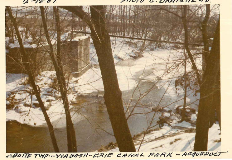
In the 1830s, engineers on Indiana canals used two styles of aqueducts. Like the Romans they built stone piers on a solid foundation of either bedrock or on a platform of long timbers. On top of the piers a flume made of timber and lined with planks was built to create a watertight box to conduct the canal waters across a stream or river. This first type of aqueduct is called an Open Trunk Aqueduct. The attached drawing shows this style at the Aboite creek crossing in Allen County.
Unless a canal structure rested on a solid stone bottom, timbers were used to provide an even platform to build a lock, culvert or piers for an aqueduct. Both stone and timber structures needed a solid foundation to build upon. Pictured below are the timbers of the Aboite Creek aqueduct west of Fort Wayne as seen at low water. Submerged timbers will stay preserved for many years
Aboite Creek Aqueduct by Mike Fromholt July 4, 2022 on YouTube. He describes himself as: Just some retired guy that likes to go around and take photos and videos of the Northeast Indiana region and other places on our travels.
A short video of the Aboite Creek Aqueduct, which carried the Wabash & Erie Canal over Aboite Creek in western Allen County. As it is a short video, I will explain more at what you're looking at as well as it's history. The Wabash & Erie Canal linked Lake Erie (via the Miami & Erie Canal) with the Ohio River, near Evansville. The major cities along the 460+ mile route were Fort Wayne(located a few miles east of this point), Lafayette and Terre Haute. Construction started in 1832 and was finished in 1853. The railroads came soon after, and abanondonment began shortly there after, with most sections no longer used by 1870. However, from the 1937 aerial, it appears the aqueduct was still in place, although not in use. Sometime before 1957, the aqueduct either fell into the creek or was removed, but the timbers across the bottom of the aqueduct ended up in the creek, and the creek now flows over them. In the video, you can see where the straight edges of these timbers as the water flows over them. I will try to get there during the fall or winter for better views. Along the south tow-path of the canal, ran an interurban railway which connected Fort Wayne to Lafayette. A power line marks it's path for most of it's leangth between here and Fort Wayne. I was told about this location by an employee of Indiana-Michigan Power back in 1981 when I was inspecting the poles on this right-of-way for my job at the time with Osmose. The Interurban railway, sometimes called the Wabash Vally Railway, operated up until about 1936, when it too was abandoned, after only operating for less than 40 years. Redding Road, at this spot, actually crossed Aboite Creek, and was the main route from Fort Wayne to Huntington. This bridge was taken out when the four-lane US 24 was built in the early 1950's. So, at this spot, three forms of transportation, water, rail and road.
The Wabash & Erie Canal crossed more than 100 streams and rivers along its route, but how was it accomplished? Read about amazing aqueducts and more in our latest blog entry... Canal Notes: The Aqueducts
Sadly, no aqueducts from the Wabash & Erie remain today, but you can still see a one-of-a-kind aqueduct at Whitewater Canal State Historic Site on the Whitewater Canal.
On the Central Canal in Indianapolis, the Fall Creek Aqueduct still carries water today! Since 1839, there have been several structures built and lost over Fall Creek, and the current structure was built in 1905.
Old Cabin-Tavern log home on US 24
Diamond in the Rough...Very Rough originally had a video of a two-story log cabin tavern/home built in the 1830s siting along old US 24 near Woodburn, at the edge of the Wabash and Erie Canal as it has for more than 150 years. It was the only stopping off point for canal travelers between the Ohio state line and Fort Wayne. Passengers would climb off the canal boat and walk fifty yards to this house for refreshment. By
Eric Olson, 21Country Featured Reporterpublished January 14, 2014 on
21Country at 21AliveNews.comarchived on the Internet Archive Wayback Machine. Log cabin is shown in the Daniel Baker photo below:
"Time goes so slowly" by Daniel Baker on flickr Street View photo on Google map near 19593 US 24 where the old canal bed is still obvious for several miles along the highway For as long as I remember, this log cabin sat empty amongst a small grove of trees in a field along US 24 near Woodburn. It predated the highway, being built near where the Wabash and Erie Canal carried passengers and supplies to Fort Wayne and beyond. Historical aerial photos show that it continued as a farmhouse through at least the middle half of the 20th Century. A barn that stood behind was removed sometime between 2003-2006. The cabin remained mostly intact until around early 2015 when its roof gave in. When I returned this summer, it had totally collapsed. US 24 (between Maumee Center and N. Sampson Roads) Allen County, Indiana 12.11.2015
A similar 1830's log cabin was a tavern on the Wabash Erie Canal in Woodburn photo is on Pinterest
The Wabash-Erie Canal posted Jan 4, 2015 by Decater Collins on YouTube Part of the Quitting The Grave series of documentaries on American frontier history. Special Thanks to Walter Font and the Fort Wayne History Center. Please visit their website here: fwhistorycenter.com/
Happy St. Patrick's Day! Irish immigrants have been a part of Fort Wayne's history from the early days of the frontier. The Irish helped build the Wabash and Erie Canal, laid rail and worked in machine shops for the Pennsylvania Railroad, and are represented in some of Fort Wayne's most recognizable names such as Hamilton, Hanna, and Swinney.
#OTD in 1835, two factions of Irish immigrants—the Corkonians and Fardowns—who had been constructing the Wabash and Erie Canal, skirmished at Lagro. The militia was called in and arrested those laborers who had not already dispersed. According to historian Jay M. Perry, “The Irish War stemmed from real and perceived grievances related to laborers’ economic concerns.” He expounded that “members had organized themselves into protective associations aimed at securing and defending the economic interests of their membership, namely preserving access to employment on the nation’s canals and railroads. Violence and intimidation, their key tools in achieving these goals, periodically resulted in brawls like the one on the Wabash and Erie [Canal].” Learn more: Canals & Conflict: How Irish Immigrants Built and Battled on the Wabash & Erie Canal
The image of canal workers below is courtesy of Indiana Public Media.