Last month we had a presentation on ghost towns of southern Allen County. The following post contains highlights from the presentation regarding ghost towns in Jackson Township.
* * *
Jackson Township was one of the last areas of Allen County to be settled, with major settlement not starting until the 1880s (in comparison, most other townships began to be heavily settled in the 1840s). This late start was due to the thick, dense forests and murky, impassible swamps that covered the area.
The four main villages in the township were all started within several years of each other—Edgerton (still in existence) in 1889, Baldwin in 1890, and Smith Mills and Townley shortly after that. The last three all owe their existence to the Findlay, Fort Wayne, and Western Railroad, which was built through the township between 1889 and 1890.
In 1889, the Findlay, Fort Wayne, and Western Railroad completed construction up to the farm of Timothy Baldwin, where they temporarily stopped for several months. Seeing his opportunity, Baldwin platted a town on his property, named after himself, on May 19, 1890. The plat included 74 lots and two streets: Elm and Main. The town was home to a hoop factory operated by William Noble, which turned out 30,000–35,000 barrel hoops per day. Noble also manufactured buggy and wagon wheel hubs. In addition, the town boasted two charcoal kilns, a grain elevator (often with 50–100 wagons waiting to be served at a time), three saloons, a commissary, two general stores, a hardware store, a Red Men’s Lodge, a church, and a school. The town, factories, and railroad all thrived while there was logging to be done, but once the lumber was all chopped, the area quickly fell on hard times. The railroad was abandoned in 1915, and Baldwin itself ceased to exist not long after that. Within 50 years, not a single building was left standing.
The greatest story to come out of Baldwin originated from a minor tragedy, after the first rail depot in the town was destroyed by fire. To prevent any disruption in the flow of people and goods, the enterprising (and larcenous) citizens loaded up a flat car, drove it to the Tillman Station further up the line, stole the entire station, and brought it back to Baldwin!
The next town on the Findlay, Fort Wayne, and Western Railroad was Smith Mills. The town was once home to a steam sawmill and a hoop and heading factory operated by William and Charles Smith. The Smiths' factory employed 40–50 men in its heyday, all of whom lived in the small town with their families. Once the railroad shut down, this town also disappeared entirely.
Finally, we come to Townley. The third town on the Findlay railroad, it was never formally platted but nevertheless thrived. A general store, grain elevator, church, and school were all built here, but were destroyed by a severe tornado on Palm Sunday, March 29, 1920. The tornado destroyed every building in the village and killed four people. It was never rebuilt. In later years, a gas station was built on the site of the former town. This was later turned into a bar—Triple T's.
Image 1—Railroad map, showing locations of Baldwin, Smith Mills, and Townley, 1914
Image 2—Baldwin plat map, 1917
Image 3—Baldwin school, 1913
Image 4—Smith Mills location, June 1, 1963
Images 5–7—Townley tornado aftermath
Ghost Towns of Madison Township
Ghost Towns of Madison Township Last month we had a presentation on ghost towns of southern Allen County. The following...
Last month we had a presentation on ghost towns of southern Allen County. The following post contains highlights from the presentation regarding ghost towns in Madison Township.
* * *
The earliest settlement in Madison Township was the small village of Massillon (or Massilon). Adam Robinson platted the town on September 5, 1851, though a settlement already existed there by that point. There were only nine lots, situated on the Van Wert Road (today known as Barkley Rd.). The first sawmill in Madison Township was established there, which later also became a corn and wheat mill. There was also a log cabin store (the first in Madison Township), a log cabin post office, a blacksmith, and Lutheran and Methodist churches. The Lutheran church was the first General Synod Lutheran church in Allen County, founded September 23, 1850. This church, known simply as the "Massillon Evangelical Lutheran Church," closed its doors around 1912. The Methodist Church existed from about 1861 to about 1898, when it merged into the Woodland Methodist Episcopal Church in Boston (see below). The town also had a resident physician, Dr. James Engle, who served the area for more than twenty years, charging $1.00 for house calls. Today, an abandoned cemetery and a single residence mark the former location of the town.
The next town to be platted in Madison Township was Centerville. The Ohio and Indiana Railroad was built through Uriah Mitten’s 100 acre farm in 1852. Sensing the possibilities, he entered a plat on January 3, 1852, including 24 lots. The town never developed, largely because Maples was founded a mile northwest in 1853 and took hold instead.
Next we come to Boston. Though never formally platted, Boston once had a thriving poultry business, two general stores, a blacksmith (Wm. Johnson), and the Woodland Methodist Episcopal Church, which closed about 1927. A small general store continued operations until the 1950s.
The last ghost town in Madison Township is Bielefeld. In 1849, several families belonging to St. John Lutheran Church, Bingen, founded a daughter congregation—today's St. John, Flatrock. Initially called the "German Evangelical Lutheran Church of Madison Township, Allen County, Indiana," the congregation was fairly consistently called St. John's in Bielefeld, Indiana, throughout the 1870s and 1880s. I haven't come across any references to the town outside of references to the church, but it seems that the small German community attempted to create a village here, perhaps along the lines of Hessen Cassel.
Finally, though not a ghost town, brief mention should be made of Hoagland, which survives as the only town in the township. Platted in February of 1872, Hoagland celebrates its 150th anniversary next year.
Image 1—Plat map of Madison Township, 1898
Image 2—Plat map of Massillon, 1898
Image 3—Massillon cemetery
Image 4—Boston aerial view, 1938. The old general store at the northwest corner of the intersection has been torn down, but the former Methodist church and residences still remain.
Image 5—The former Woodland Methodist Episcopal Church in 2008
Image 6—The former Methodist church today. Many people mistakenly believe this structure was once a school.
Image 7—Part of the first page of St. John, Flatrock's first church record book. The top reads, "Congregational property, 1866, Bielefeld, Ind." while the middle section reads "St. John's Congregation, Bielefeld"
Ghost Towns of Marion Township ( Part One and Two )
Ghost Towns of Marion Township (Part One) In August, we had a presentation on ghost towns of southern Allen County. The...
In August, we had a presentation on ghost towns of southern Allen County. The following post contains highlights from the presentation regarding ghost towns in Marion Township. Marion Township historically had an usually large number of small towns, most of which have all but disappeared. We will therefore have two separate posts on Marion Township ghost towns. This week's post will look at Root, Jericho, and Middletown, and next week's will look at Hessen Cassel, Soest, and Gorham Station.
* * *
Hiram Mooney opened the first store in Marion Township in 1832, just south of where Hessen Cassel is today. Five years later, John Karn opened a small story-and-a-half log tavern just south of there—a tavern that in later years gained the name of Nine Mile Restaurant, named after its distance from Fort Wayne. The present-day structure was constructed by John Holmes in 1851, though it has been expanded many times over the past 160 years. The Root post office was also established across the street in 1835, where it remained until 1851. Though no further settlement ever developed, Nine Mile remained an important stop on the way to Fort Wayne for more than a century.
The first formally platted town in Marion Township was Jericho, surveyed March 13, 1837, by David Hoover and platted April 20 of the same year. The town was located in Section 33 on the left bank of the St. Mary’s River and contained 50 acres divided into 200 lots. At the center was a public square with reservations for Baptist, Methodist, and German churches and also a school house. Despite the grand plans, no buildings were ever constructed.
The first successful town in the township was Middletown. In 1850, a private company received permission to plank U.S. 27 and turn it into a toll road. They erected a sawmill and toll booth for that purpose just south of the present intersection of U.S. 27 and Hoagland Road. Then on April 15, 1851, Louis Lopshire, Eli Harrod, F. Hull, and Frederick Rhoades platted a new 59-lot town at that location, which they named Middletown. Within a few months, the Root post office moved to Middletown, though it retained the Root name. William Moody opened a grocery, and there were also a dry-goods store, blacksmith, wagon factory, steam-powered sawmill, Methodist church, thriving school, Masonic lodge, and a hotel. The post office still stood as of the 1940s, the hotel still stood as of the 1970s, and the 1871 school building survived until the mid-1980s. The school was a two-story brick structure and was commonly known as the “select school,” with some advanced classes offered already in the 1860s. Pupils came from a considerable distance to attend this school, as credits obtained here were accepted for entrance to the old Methodist College in Fort Wayne. A two-year high school program was also offered from 1901–1903.
Though the school remained in operation until the early 1900s, the rest of the town had already nearly disappeared by that point. An 1880 history tells the tale:
"The village of Middletown is one of the monuments of the past, which dot the once great thoroughfares throughout the State of Indiana, one of the reminders of the days when a line of stage-coaches was the genius at whose magic touch towns sprang into existence, through whose instrumentality those towns were to grow metropolitan, and, in the minds of their residents, become the very centers of the universe. . . . How the construction of a railway dispelled these proud hopes, and drained the once prosperous towns of their very lives, is a fact attested by a host of ruined hamlets, not only in this county, but elsewhere. Middletown is an example.
"About 1857, a dark cloud threw its shadow over the rising hopes of the citizens—the Fort Wayne, Richmond & Cincinnati Railway was to be constructed, and Middletown was not to be a point on the route. Its death-knell seemed to ring in that mystic word, “railroad;” its merchants took alarm, and removed their goods to other localities; the stage line lost its customary quota of passengers, in view of the better facilities offered by the railroad, and, in a brief space, Middletown was only the ghost of its former self. It is now a quiet hamlet, without even a hotel or store."
In February 1904, the Fort Wayne and Springfield Electric line was built through the former town. The trolley line was abandoned in 1915, and the brick substation was repurposed into apartments and later a small factory.
Next week's post will look at Hessen Cassel, Soest, and Gorham
Image 1—Marion Township plat map, 1907
Image 2—Michael Orr, owner of Nine Mile during the Civil War
Image 3—Nine Mile, c. 1930
Image 4—Middleton plat map, 1898
Image 5—Middleton school, unknown date
Image 6—Middleton school, 1891
Image 7—Old trolley electric substation. In later years, it was repurposed as apartments and a nickel plate factory.
Ghost Towns of Marion Township (Part Two)
Ghost Towns of Marion Township (Part Two) In August, we had a presentation on ghost towns of southern Allen County. The...
In August, we had a presentation on ghost towns of southern Allen County. The following post contains highlights from the presentation regarding ghost towns in Marion Township. Last week's post looked at Root, Jericho, and Middletown, while today's post will look at Hessen Cassel, Soest, and Gorham. Part 1 is available here: https://www.facebook.com/friendsofwyneken/posts/10159194427328617
* * *
In 1832, the Weisheit, Linker, and Schmitt families immigrated to the U.S. from Hesse, Germany, ultimately arriving in Fort Wayne in 1833. On November 26 of that year, the Weisheits and Schmitts purchased land from the U.S. government several miles south of the city. Only a year later, a group of Hessian immigrants followed them, founding a small community which they named Hessen Cassel. St. Joseph Catholic Church was founded there in 1841, and a school seems to have been started a year later.
The early members of this community included the Sorgs, Klugs, Herbers, Kracks, Auths, Lauers, Klingenbergers, and Zieglers. The Irish Muldoon, Hart, and Cody families followed in 1843, and the Swiss Zuber and Wyss families followed in 1849. The current brick church was constructed sometime between 1857 and 1861, and the first convent was constructed in 1859 or 1860. In 1863, a town was formally platted across the street from the church, but only a single house was ever built there.
While the Hessen Cassel immigration story has been told a number of times, one detail that is often overlooked is that the original group of immigrants consisted not only of Catholics, but also of Lutherans. The Weisheit and Linker families were Lutheran, and they were soon joined by a host of co-religionists, many of them Hessians. These Lutherans started their own church in 1841, which today is known as Emmanuel Evangelical Lutheran Church. In 1861, the church moved to its current location, and a couple of years later, Louis Soest opened a general store across the street. Louis Soest also became the town's first postman, giving his name to the post office and from there to the entire town. Other businesses were added over the years—a cigar manufacturing operation, a blacksmith shop, a wagon wheel factory, and several sawmills.
Today, only the church and school survive as ongoing operations, though the buildings that once housed the blacksmith shop, one of the sawmills, and the general store are still in existence. The blacksmith forge is currently on display at the History Center in Fort Wayne.
Image 1—Marion Township plat map, 1907. Note that "Gorham" is misspelt "Gohrman." This spelling appears commonly in period plat maps, but it seems to be an error. The existing school's cornerstone reads "Gorham" and one of the railroad's directors at the time was F. A. Gorham.
Image 2—St. Joseph, Hessen Cassel, 1876
Image 3—Hessen Cassel plat map, 1898
Image 4—Emmanuel, Soest, c. 1902
Image 5—Ferber blacksmith shop, 1925
Image 6—Ferber blacksmith at the Allen County History Center in Fort Wayne
Image 7—Gorham school, 1927
Image 8—Gorham school today
Ghost Towns of Monroe Township
Ghost Towns of Monroe Township Last month we had a presentation on ghost towns of southern Allen County. The following...
Last month we had a presentation on ghost towns of southern Allen County. The following post contains highlights from the presentation regarding ghost towns in Monroe Township.
* * *
For almost a century and a half, Monroeville has been the largest and most important town in Monroe Township. It is not, however, the oldest. That honor goes to East Liberty, which was originally platted by John Burger on February 27, 1848. The town grew quickly, eventually housing a post office, tannery, saloon, three churches, and a public school. The first store in town was opened by one Martin Kemp, though his primary stock was alcohol. Later, Judge Reynolds and James Patterson opened a better-equipped general store, which soon became one of the largest general stores in the county.
In 1851, only three years after East Liberty was founded, Jacob and John Barnhart platted the town of Monroeville on the Pittsburgh railroad. Although Monroeville didn't develop beyond a post office for its first ten years, it nevertheless ushered in a steady period of decline for East Liberty, as all its businessmen and most of its residents moved north to the new town. By the late 1800s, all that was left of East Liberty was the public school, Bethlehem Church of the United Brethren (corner of Barkley and 101), and Shiloh Methodist Episcopal Church (1/2 mile north). In 1968, these two congregations merged to form East Liberty United Methodist Church.
Aside from Monroeville, which certainly doesn't count as a ghost town, the only other settlement in Monroe Township was Dixon, which straddles the Ohio/Indiana border. Platted in 1854, the town's growth was hampered by its position, half in one state and half in another. Dixon once claimed a post office, school, rail station, two blacksmith shops, two general stores, a grocery, a succession of grain elevators, several other small stores, a church, and a number of other small independent businesses (carpenter, physician, etc.). Today, almost nothing remains but a collection of houses and a few empty stores.
Image 1—Plat map of Monroe Township, 1907
Image 2—Plat map of East Liberty, 1898
Image 3—East Liberty School, c. 1909–1910. Such interior school photos from this time are relatively rare.
Image 4—Bethlehem Church of the United Brethren, East Liberty (today, East Liberty United Methodist Church), 1946
Image 5—East Liberty United Methodist Church today
Image 6—Dixon, Indiana, plat map, 1898
Image 7—Dixon, Ohio, post office, date unknown
Image 8—Dixon Cornet Band, c. 1888–1890
Image 9—downtown Dixon, c. 1950
Image 10—History of Dixon, taken from Thaddeus S. Gilliland, "History of Van Wert County, Ohio and Representative Citizens" (Chicago: Richmond & Arnold, 1906), 185.
Original information from Linda Churchward, with 2012 corrections from CW Martin posted below. Most of this information came from Allen County history books now online at Archive.org posted on other Allen INGenWeb pages. When time permits will include links to each town to the correct pages in those online books.
Town
Township
Section
Platted
Status
Features
Aboite
Lafayette
1891
village
Village founded on the Wabash Railroad seems to belong to Aboite Township, but is in Lafayette Township. Has a drain tile plant, a farmer exchange, a grocery and a church. Only a few houses remain today. The church building is still there, but has been vacant for a few years. Interesting discussion with links to early books June 9, 2017 on You are positively from Fort Wayne, if you remember... Archived group only visible to existing members on Facebookabout a blog Aboite, Indiana Named For Indian Massacre and French Word For "Slaughterhouse." by Fritz Zimmerman published September 11, 2013 on Blood on the Ohio Tales of Frontier Terror.
Academie
Washington
1874
ghost town
Academie was located on the Lake Shore Railroad, but never developed.
Adams Station
Adams
22
ghost town
Was at the junction of the Pittsburgh, Ft. Wayne & Chicago and the Cincinnati, Richmond & Ft. Wayne railroads from Craig Berndt email September 2021.
Arcola
Lake
1866
town
Second saw mill in the township was erected near the future site of Arcola. Building of the Pittsburgh, Fort Wayne and Chicago Railroad, the mill provided the impulse for the town. Name Arcola was adopted for the post office in 1858. The town of Arcola was platted in 1866. The Peabody Mill became the largest in the county and employed many people. It furnished hard wood lumber to the Pennsylvania Railroad for car building, shipped lumber to the Pacific Coast and exported finer grades of lumber to Scotland. Other industries established there such as the Arcola Stove Co. and the Clay Products Co. Small town of Arcola still exists today. Best known for its volunteer fire department sponsored Arcola Tractor Pull occurring during the Fort Wayne Three Rivers Festival. December 18, 2009 oldest building burns
Ari
Eel River
4
community
Also known as Potter’s Station – Ari is located at the Noble County line. Was a station on the Detroit, Eel River & Illinois Railroad. Still a small community today.
Baldwin
Jackson
35
1890
ghost town
Platted by Timothy Baldwin on his land. The east line of plat was on Ohio-Indiana State line. Rise and decline of Baldwin occurred in little more than a quarter of a century. When the Findlay, Fort Wayne and Western Railroad was built from Findlay, OH westward, work stopped at Baldwin in the year 1889, and was not continued until following year. A “Y” track was built at Baldwin for turning locomotives. The first depot built at Baldwin was destroyed by fire and a story that the people of the community stole the station at Tillman on the same railroad, took it to Baldwin on flat cars and placed it on the Ohio side of the line. In its day, Baldwin was a very busy place. William Noble operated a large hoop mill. Besides hoops, he also manufactured hubs for buggy and wagon wheels. The Clifford Brothers operated two charcoal kilns, which were supplied from heavy timber in the vicinity. Nathan and Levy operated an elevator at Baldwin, and it was not an uncommon sight to see from fifty to a hundred wagons waiting to be served at the elevator. Three saloons operated in Baldwin in 1906. Noble hoop factory, for the benefit of their employees, operated a commissary. Two general stores in operation and a hardware store owned by the Sorgan Brothers. A schoolhouse and a church were also located there. With the abandonment of the Findlay railroad in 1915 and the depletion of the timber supply in the vicinity, Baldwin soon went out of existence. Nothing on site today to indicate that a thriving community once existed there.
Beech Grove Corners
Lafayette
18
ghost town
Small community grew up around the Beech Grove Disciples Church and the Beech School. Nothing remains today.
Bengal
Maumee
9
March 1836
ghost town
Maumee Township leads all townships in number of proposed towns platted within it borders. Among these was Bengal, platted by Joseph Sinclair and Thomas Tigar. The site was situated on both sides of the Wabash and Erie Canal about one-half mile south of the Maumee River and two miles northeast of the town of Woodburn. The plat contained 273 lots. The site never developed.
Besancon
Jefferson
1840
village
Before there were any roads in Jefferson Township, a colony of French immigrants formed a settlement known as “New France”. When the St. Louis Catholic Church was founded in 1851, a little village grew up around the church called Besancon.
Boston
Madison
ghost town
Located four miles east of Hoagland on the Hoagland Road. Nothing remains of this community.
First town established in township, situated in forks of St. Joseph River and Cedar Creek, in Section 28. It’s founders had provided a square in the center of the plat for the erection of the Allen County Court House with dreams of its becoming a city. After the platting of Leo, Hamilton as it was called in 1849, Cedarville’s attraction waned. Leo - Cedarville are new considered as one community. Episode 175: Leo and Grabill by Granite Ridge Builders interesting video includes some history and current events for Leo-Cedarville and Grabill.
Centerville
Madison
NW 4
1852
ghost town
Uriah Mitten owned 100 acres of land. The Ohio and Indiana Railroad was built through his tract in 1852. Seeing the possibilities of developing a trading center here, he entered a plat in January 1852, and offered the railroad a sizable piece of ground if they would build a spur track on his plat. The railroad failed to take advantage of his offer and his dream of a town at this place never materialized.
Chillicothe
Wayne
1788–1792
Indian village
Chillicothe was a Shawnee Indian village around 1788–1792 on the Maumee River east of the Miami Indian village Kekionga. There were 58 houses on one side of the river and 16 houses on the other side from an 1812 map published in 1933 in The News-Sentinel newspaper. The village was ordered destroyed by General Harma during his campaign against Kekionga in October of 1790. From a discussion May 23, 2019 on You are positively from Fort Wayne, if you remember... Archived group only visible to existing members on Facebook.
Chamberlain
Milan
1856
ghost town
A post office was located here.
Clabbertown
Lafayette
SW 9
1874
ghost town
Existed about a quarter of a century at the intersection of the Lower Huntington and Winters Roads. Dick McGinnia operated a blacksmith shop there about 1874. John Mills owned the general store and saloon. Some years before, a sawmill was built there, but the proprietor’s name is not known. John Mills died in 1897, and the grocery and saloon were closed. McGinnis closed his shop and moved from the area about 1900. The sawmill had ceased operation before this time, so Clabbertown soon vanished. No trace of the settlement exists today.
Collingwood
Perry
1
ghost town
Many years ago, the hollow that became the site of the church, school and Eli Garman’s general store on the Auburn Road. Today the Garman store is gone. The Dutch Ridge country acquired its name from the Pennsylvania Dutch settlers who came in when Indiana was opened for settlement in 1832. In early days, the community of Dutch Ridge revolved around the church, school, mill and post office.
Cuba
Springfield
SW 32
June 1855
ghost town
The Ridge Road, later known as the Hicksville Road, has always been a busy highway with the result that several towns have been platted along its course. Post offices were established and taverns and tollhouses sprang up along its route. This road is now designated as S. R. 37. Cuba was situated on the Ridge Road about one mile southwest of Harlan. The plat was surveyed and entered by Andrew Metzger. Considerable activity developed at Cuba. A saw mill was located here, also a school, a church, a store, and a tollhouse. First post office in Springfield Township was established here in 1849 before Cuba was platted. Office was moved to Harlan in 1854. A tollhouse and post office building was built in 1849. Tollhouse continued in operation until 1888 or 1890. Last toll collector was Eli Dial. Cuba declined with the development of Harlan and all trace of the village has disappeared.
Dawkins
Jefferson
12
ghost town
On the Nickel Place Railroad, was located about a mile west of S. R. 101. Had an elevator and general store.
Dixon
Monroe
village
On the state line, was once an active collection and shipping point for lumber and lumber products. Most of the residences in Dixon are on the Ohio side of the main street, which is directly on the line. An elevator and a few stores are on the Indiana side.
Dunfee
Aboite
6
1883
town
Shipping point on Nickel Plate Railroad, straddles Whitley Allen County line
Was on the way to becoming a sizeable town, about two miles south of Monroeville on S. R. 101. The town had expected the Pennsylvania Railroad would pass through their town. There had a tannery, three churches, a school and one of the largest general stores in the county. Remaining today are a church and several homes.
Edgerton
Jackson
1889
town
First town developed in Jackson Township. Established on the Nickel Plate Road, now S. R. 14 at the Ohio line. With its elevator, the town became a shipping center and a distribution depot on the Nickel Plate Railroad.
Edwardsburg
Maumee
NW 18
January 1871
ghost town
One of the proposed canal towns of Maumee Township. Situated between the Wabash and Erie Canal and the Maumee River. Located on U.S. 24 at the intersection of the Bull Rapids Road about two miles northwest of Woodburn. E. D. Ashley entered the plat, containing 9.43 acres. Platted shortly before the abandonment of the canal, with result that it had no opportunity to develop. Little is known of the village except that a post office was established here and a general store operated for a short period of time.
Ellison Station
Aboite
26
ghost town
1898 map on the Wabash Railroad - called Prairie Switch on 1914 map
Apparently the proprietors of the proposed town of Fairport had intended giving the small town of Fort Wayne some competition, as this was the largest plat recorded up to that time and one of the largest ever recorded in Allen County. It is thought that James Weldon and John Jamison were backed by eastern capital when they entered their plat. The year following, two additional plats to Fairport Were recorded, making a total of 675 lots in all. The original plat was located on both sides of the Wabash and Erie Canal, in the west half of the northeast quarter of Section 24, Milan Township, on the Maumee River and about half way between the Gronauer and Saylor locks of the old canal. Shortly after the plat was entered, George Foxtater opened a tavern for the convenience of travelers on the River Road and the canal. A post office was opened and John Irwin became the first postmaster. He also operated a tavern and a general store. An unsuccessful effort was made to create a thriving canal town here. The post office eventually removed to Chamberland on the Ridge Road to the north, now S. R. 37, and with the decline of the canal’s use, Fairport was soon forgotten. The Gronauer Lock was rediscovered during building of the I-469 bypass around Fort Wayne and was moved to the Indiana State Museum in Indianapolis.
Fansler
Scipio
ghost town
Was located at the intersection of Allen and Worden Roads and had a post office and general store. Nothing remains of this community today.
Ferguson Station
Pleasant
ghost town
Located on the Fort Wayne,Muncie & Cincinnati Railroad from Craig Berndt email September 2021.
3 different forts were built in late 1790's-1800's, largest city in northeast Indiana. The county seat and second largest city in Indiana now covers most of Wayne, Washington, St. Joseph, Adams, and Aboite townships and part of neighboring Perry and Pleasant townships. The Wabash and Erie Canal and various railroads were built in the 1850's through Fort Wayne. Home to the Allen County Public Library, whose Genealogy Center, is the largest public genealogy library in the United States. Best known for the Fort Wayne Three Rivers Festival the second largest outdoor event in Indiana to the Indianapolis 500.
Frenchtown
Wayne
after 1846
Locality
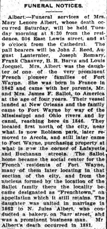
Mentioned on page 11 in the St. Peter's Catholic Church, Diamond Jubilee, 1872-1947, Fort Wayne, Allen County, Indiana at The Genealogy Center as the extreme southeast area of Fort Wayne in 1871. A more specific location is the Lafayette and Buchanan Streets area. Identified in the January 25, 1909 obituary of Mary Lenore Sallot Albert obituary. Born in 1842 France, Mary arrived with her parents, Mr. and Mrs. James F. Sallot in Fort Wayne in 1846 by way of the port of New Orleans then the Mississippi and Ohio Rivers and canals. When the Sallot's bought land at the corner of Lafayette and Buchanan Streets their home become the social center for local French residents who began to refer to the locality as Frenchtown as it was still known in 1909 when the obituary was published. Discussed April 17, 2018 on You are positively from Fort Wayne, if you remember... Archived group only visible to existing members on Facebook.
According to literature available at the Historic Fort Wayne, in 1816 an area outside the fort was known as Frenchtown consisting of some French traders, Native Americans and a few women, down from the several thousand who populated the town in the 1790s. Copied from Old Fort celebrates state's Bicentennial by Jamie Duffy published June 12, 2016 in The Journal Gazette newspaper.
Once a shipping point on the Wabash Railroad. A small community of 500 souls built up around the station. History of Gar Creek Mennonite Church, now extinct, is online. A 3 page article appeared in the March 2011 Allen County Lines quarterly newsletter.
Geneva
Maumee
14
November 1836
ghost town
Third of the paper towns of Maumee Township. Located about two miles northeast of Woodburn and one-half mile west of the Ohio-Indiana State line. C. C. Waterhouse entered the plat, but no headway was ever made toward settlement.
Was possibly the area around Gloyd’s Grist Mill located where the Griffith Road intersects with the Auburn Road on Cedar Creek.
Goeglein
St. Joseph
26
1857
ghost town
Hardly large enough to be called a village, was the only trading spot in the township. Most know the area only by the popular Goeglein's Catering. Local resident Tim Goeglein was a Special Assistant to President George W. Bush from 2001 to 2008.
Gohrman
Marion
ghost town
Was a flag station on the Cincinnati, Richmond & Ft. Wayne Railroad from Craig Berndt email September 2021.
Shipping point on the Chicago & St. Louis Railroad
Hall’s Corners
Springfield
on line 13 14
ghost town
Village was never formally platted. A post office was established here in 1851 and named for Isaac Hall, the owner of a large tract of land at the village site. A general store was operated at Hall’s Corners for a number of years. A Methodist Church was built here and a number of dwellings erected. These have all vanished. Village was located on the old Ridge Road, now S. R. 37, about 3 ½ miles northwest of Harlan.
Harlan was platted by Mr. And Mrs. Lewis Reichelderfer. The unique incident of Springfield Township’s main town came in 1859 when a second town was platted immediately adjoining Harlan, only separated from it by a section line, and given the name of Maysville. These apparently rival towns grew up side by side. The post office was in Harlan, but for a time Maysville was the more popular name. Then the tide of public favor turned back to Harlan. Situated on S. R. 37, one of the main traffic routes, Harlan is not served by a railroad. Today the two towns are one and the official name is Harlan.
Heller’s Corners
and
Old Heller's Corner
Eel River
21
and
31
1830
ghost town
1898 map shows Heller's Corner in Section 21, with Old Heller's Corner in Section 31. Peter Heller settled in Section 31 about 1830 and shortly thereafter opened a general store and post office on the old Goshen Road near it’s crossing of the Eel River. A small village soon developed, became a very active center of trade, remained so until about 1870, when the Detroit, Eel River and Illinois Railroad was built through Churubusco a few miles to the north in Whitley County. Heller’s Corners soon passed out of existence. Heller's Corner article in the NEWSLETTER of the North Manchester Historical Society, Inc. VOLUME XIX, NUMBER 3 (AUGUST, 2002). See Heller's Corner - Hardin's Defeat.
The St. Joseph Roman Catholic Parish was organized in 1841 and a church building was erected the same year on the old Piqua Road. The church property is located on the east side of the highway which is now U.S. 27. Opposite the church property was 33 platted lots. Two streets were included in the plat known as St. Joseph and George Streets. No improvements were ever made on the plat. Many of the early settlers in the vicinity migrated from Hesse-Kassel, Germany, for which the town was named.
Hoagland
Madison
1872
town
Stephen Emenhiser platted the village of Hoagland upon land belonging to himself, adjacent to the right of way of the Cincinnati, Richmond & Fort Wayne Railroad. Joseph Harrod at the same time gave to the railroad a plot of ground for the depot, stipulating that the new town should be called "Harrodsburg." The gift was accepted, but the agreement was not carried out, the name of Hoagland being substituted, in honor of Pliny Hoagland, of Fort Wayne, who was a director of the railroad. The post office in Hoagland was established on March 7, 1872 with James English appointed the first postmaster. From History of Hoagland from "The Hoagland Centennial, 1872-1972, Author - Hoagland Area Advancement Assoc. Inc. Five old school and building photos were posted December 10, 2017 on You are positively from Fort Wayne, if you remember... Archived group only visible to existing members on Facebook. From page 628 of the 1917 Pictorial History of Fort Wayne by B. J. Griswold.
On Lima Road and the only town in Perry Township, was a natural gathering place for settlers’ homes. Known as the “opening” it was the only spot for miles around that was not covered by forest. It was situated on a slight rise of ground with muck land both on the north and the south. At some earlier date these prairies had burned out, destroying the trees. A number of settlers lived in houses at “the opening” while making clearings for their farms. There had been a village there for some time before the Grand Rapids and Indiana Railroad crystallized the settlement into an organized town. As many as forty-five town lots were sold in one day after the plat was opened and Huntertown grew rapidly as a shopping center. Today Huntertown has a population of about 1350. See Huntertown Historical Society Family Files From the Huntertown Historical Society at The Genealogy Center.
Hurschtown – Urbana Mills was about three miles above Leo on the St. Joe River. A sawmill and gristmill were erected in 1871, a general store and school. A few homes were built in vicinity, but no town developed. The Hurschtown Bridge now spans the river at the site. Most know area only as the Hurshtown Reservoir built as an emergency water supply for the city of Fort Wayne, but has never been used.
Indiana City
Maumee
7 & 8
July 1836
ghost town
Second of the proposed towns of Maumee Township was Indiana City, platted by James Shirley. The site was located to the east of the present Bull Rapids Bridge, where the Bull Rapids Road crosses the Maumee River about one-quarter mile north of the Wabash and Erie Canal. Gregory Jackson opened a tavern and grog shop there in 1833, and a few homes were erected in the vicinity. The hardened crowd that frequented the Jackson barroom soon gained a bad reputation, his trade gradually fell sway, and the land was shortly afterward purchased by James Shirley, who platted a town there. The name of Indiana City could not disguise the former reputation of the locality, which has always been referred to as Bull Rapids. The source of the name Bull Rapids is shrouded in legend, the tradition being that an old hunter on reaching the Maumee rapids at this place encountered a bull buffalo browsing in the shallows of the river. The town never came into being, however in later years a Lutheran church was erected across the river from this site.
Several proposed towns were platted in the south half of Marion Twp., the first one being Jericho, which was surveyed March 13, 1837, by David Hoover on the left bank of the St. Mary's River about one and one-half miles west of the old Piqua Road, new US 27, and three-quarters of a mile east of Williamsport (Poe). Jericho never developed beyond the plat.
Kraco
Eel River
1835
ghost town
A village called “Kraco” or Cracon was platted in 1835 by Asa Miller, on land on both sides of Eel River and Lake Township lines at intersection of Felger Road and U.S. 33. The main thoroughfare was 132 feet wide. Two and one-half acres were set aside for a public square to be known as Miller Park. Origin of name is uncertain, but was probably named to commemorate Krakow, the ancient capital of Poland. Town never materialized.
Originally called Hamilton, about one mile father up the St. Joe River was more near the center of the township. Located in Section 15 and north quarter of Section 22. Today Leo - Cedarville is considered one town. Episode 175: Leo and Grabill by Granite Ridge Builders interesting video includes some history and current events for Leo-Cedarville and Grabill.
Lewisburg
Wayne
June 1837
ghost town
First township to be settled was of course Wayne. The first town platted in Wayne Township outside the city limits of Fort Wayne was Lewisburg. Waynedale was platted many years later. The Lewisburg plat was entered by Lewis Mason, and contained 48 lots. It was situated a little to the west of the center of Section 33. The Lewisburg Road, connecting the Lower Huntington Road and State Road 3, was named for this proposed town, which like many of these early plats, never materialized.
Little River P.O.
Pleasant
ghost town
No additional information available
Maples
Jefferson
1852
village
On the Pittsburgh-Fort Wayne Railroad, enjoyed activity that went with the lumber industry. Today it is quiet suburban village with its white church and a few homes. December 21, 2024 post about the Maples Inn/Saloon on True Fort Wayne Indiana History on Facebook. Named for Lewis S. Maples lumber baron.
Massilon
Madison
26
1851
ghost town
A small plat was entered by Adam Robinson in Sep 1851, which he designated as Massilon. Only nine lots included in the plat, located on the south section line of Section 26, about four miles southeast of the village of Hoagland. It was situated on what was then known as the Van Wert Road, and the only street included in the plat was named after the proprietor. There was a Lutheran Church there, but nothing remains today.
The Piqua Road, now U.S. Highway 27, was one of the principal routes leading to Fort Wayne from the south. The road was planked in 1850, and several trading centers were built along this thoroughfare, the most important of which was Middletown, situated in the northwest quarter of Section 17 in Marion Township. The town became a very active community center, only to decline and eventually pass out of existence after the building of the Cincinnati, Richmond and Fort Wayne Railroad through Hoagland, three miles to the east of Middletown.
Joseph Mosier platted a village on his land, adjacent to the newly constructed Lake Erie, Wabash and St. Louis Railroad right-of-way. The site of the plat was about one-half mile northeast of the village of Gar Creek in the southeast portion of the township. The plat never developed.
Nail
Jefferson
NE 28
unknown
Seen on the 1898 map for Jefferson Township.
New Haven
Adams
1839
town
Shortly after Wabash and Erie Canal opened to traffic town came into being. Located at “Gundy’s Deadening”, eight miles east of Fort Wayne, hoped to profit from movement on canal. Town platted by Eben & Henry Burgess. Incorporated in 1866. Eban Burgess sold eight acres to son Henry in 1836 for $1,600, the younger Burgess platted the area and named the fledgling settlement New Haven after the family's hometown in Connecticut. See our New Haven page.
Nine Mile
Pleasant
7
village
Where the Winters Road, Indianapolis Road (S. R. 3) and Coverdale Road cross. This area at one time had three churches.
Goshen Road, first road built through Township, was surveyed in 1830. Samson Pierson who migrated from Ohio to Lake Township, in 1835 erected the first mill. He settled a little to the west of the center of the township on the old plank road, known as the Leesburg Road. Later, he moved to Iowa, but during his stay in Lake Township proved to be a very active and progressive citizen. The Plank Road Company erected a steam mill near Pierson’s land in 1849. William Thorpe purchased the mill from the company in 1850 and operated it as a planning mill until sold by him to A. N. and O. D. Holt. About this time, a general store was operated near the mill. A plat of seven lots was entered by Samson Pierson in August 1853, and named after him. The plat was located in Sections 16 & 17 on the south section line near the old mill. The site of this plat is near the crossing of the Leesburg Road and U.S. 30 about two miles north of the town of Arcola. No activity took place here other than the mill.
Also known as Bubb's Nine Mile, At the intersection of U.S. 27 and the Flat Rock Road in Marion Twp. was formerly a tavern know as the Nine-Mile House. The Root Post Office was located there until removed to Middletown.
Royville
Sign at Coldwater and Union Chapel Roads says Royville. A family named Roy lived in the area.
Saylor’s Lock
Maumee
1841
tavern
Locks were built at intervals along the Wabash and Erie Canal. One of the best known in the area was the Saylor Lock. In 1841 Elrich Saylor, Sr. moved near the lock and cared for the lock. He kept a tavern for travelers.
A mile west of Baldwin, became active after the Findlay, Fort Wayne and Western Railroad extended its line westward through Jackson Township to Fort Wayne. Surrounding country was heavily timbered, which combined with new transportation outlet, created ideal location for lumber fabricating plant. William and Charles Smith operated steam sawmill, hoop and heading factory for a number of years until timber supply vanished and railroad was abandoned. Mills employed forty to fifty men, with their families resided in the vicinity. Was located on line between Sections 33 and 34, one mile west of the Ohio-Indiana State line. All traces of the former settlement have vanished.
Soest
Marion
1861
ghost town
On Wayne Trace the village of Soest was a settlement of German Lutheran families. The Emanuel Lutheran Church and school are the center of activity there.
South Wayne
Wayne
1888
merged
The town no longer exists, yet it can hardly be classed as a ghost town, as it is now one of the beautiful residence sections of the city of Fort Wayne. The first effort to incorporate the community as a town was made in 1872, when a petition was signed and presented to the County Board of Commissioners by Judge R. S. Taylor, S. B. Bond, C. B. Bond, Judge John Morris, Dr. Isaac Knapp, G. E. Bursley, H. C. Hartman, Judge James A. Fay, Daniel Markey, Judge L. M. Ninde, and many others. However, many difficulties ensued and much litigation followed. Not until 1888 were efforts to incorporate successful. The town retained its corporate status until the year 1894, when it was annexed by the city of Fort Wayne. The town occupied that portion of Fort Wayne lying south of Creighton Ave. and west of Webster St. A Board of Town Trustees composed of William J. Vesey, Harry W. Ninde and Owen N. Heaton.
Was at the intersection of Shoaff Road, Kell Road and the Fort Wayne & Jackson Railroad, from Craig Berndt email September 2021.
Summerset
Milan
22
December 1834
ghost town
George Platter and Jacob Wendell platted the proposed town on the south bank of the Maumee River, near a point commonly referred to as Five Points, which is the intersection of the Webster Road and U.S. 24. Nothing every developed here.
Taw-Taw (Tah-Tah)
Lake
NE 29
1840's
ghost town
The first post office in the 1840’s township was established in John Crawford’s house, at a place known as Tah-Tah or Taw-Taw, in honor of an Indian.
Came into prominence after construction of Findlay, Fort Wayne and Western Railroad. Village was never formally platted but developed into quite an active trade center. A general store, grain elevator and a church existed, and a number of residences. A severe tornado struck Townley March 28, 1920, completely wrecking the village, and killing four of its residents. No rebuilding was ever done, for in the meantime, the railroad had been abandoned and there was little incentive for further activity. Townley was located in the northeast quarter of Section 31 on the route of the present U.S. 30.
First post office in township, located at the Vermilyea House, stop on the Wabash and Erie Canal
Wallen
Washington
1870
locality
Village of Wallen was platted after the construction of the Grand Rapids and Indiana Railroad. For several years some quite important industries flourished in the town. Most prominent being a large saw mill and tile yard. Today a church and Washington Center Elementary School stand as centers of activity. The considerable groupings of suburban homes in the area have been built along S. R. 3, the groceries and other businesses are now on the highway and what remains of the village stands little away from things, almost unnoticed.
Walnut Ridge
Springfield
14
ghost town
Was a community surrounding the Walnut Ridge Lutheran Church on S. R. 37.
1958 annexed into Fort Wayne, but maintains separate name. Has own local newspaper the Waynedale News. See the Waynedale page.
Wesley Chapel
Eel River
20
ghost town
New Heller’s Corners – Wesley Chapel was located at what is today the Wesley Chapel Road and Watterson Road. All that remains is the Wesley Chapel United Methodist Church.
The town of Williamsport was established at Muldoon's Mill on the St. Mary's River in 1848 on land owned by William Essig from whom it derived its name. Click William Essig's link for more information. When the post office was established it was found that the name Williamsport was already on the map of Indiana so the post office was given the title of Poe. An addition was platted in 1874 and the town attained a population of about one hundred. Stories about the history of Poe : Allen County, Indiana, on the letterhead of Fort Wayne chapter, Order of DeMolay.
When did the Williamsport name change to Poe?May 28, 2024 discussion on True Fort Wayne Indiana History on Facebook. Here are some representative newspaper articles that mention both names. There were a couple more similar articles found than shown here.
city of 1,600+ in 2014, second smallest city in Indiana (passing Cannelton with 1,532 in 2014), web site: cityofwoodburn.org
In August 1855 the Wabash Railroad completed the construction of the section of railroad from the Indiana and Ohio state line to Fort Wayne. The town was known as Phelps Station, when it was nothing more than a station on the railroad. In 1865 Joseph K. Edgerton and Joseph Smith platted the town of Woodburn. In 1895 William Gernhardt platted an addition to the town and called it Shirley City, which was the name also used to incorporate the town. In February 1956 a special meeting was called, and the official name of Shirley City was changed to Woodburn. The town was slow to develop, probably because of the swampy condition of the land. When the railroad cut through this woodland, it opened the way for men like Joseph K. Edgerton, who at one time owned more than one half of the land in Maumee Township to found the town at this location were there was plenty of timber, fertile soil, the railroad and the river. The town has continued to grow and improve with the years. See Woodburn on Wikipedia, The Free Encyclopedia and Woodburn, Indiana WikiVisually.
Sheldon came into being after the construction of the Fort Wayne, Muncie & Cincinnati Railroad. Andrew J. Taylor made the original plat, arranged with the railroad for siding facilities for his carriage business. The village was named Sheldon in honor of the superintendent of the railroad. The railroad in later years changed the name of the station to Yoder. The carriage business flourished and built an enviable reputation for their wares. The carriages were sold by action at the plant and sale day often brought as many as a thousand buyers to the town. The Taylor buggy was the popular conveyance of the period. Other industries were drawn to the town. In its heyday Sheldon had a tile plant with three large kilns, two saw mills, a cooperage plant, two grain elevators, a bank, two hotels, the stores and shops that go with such a town and an outstanding and notorious reputation for murderous fights and brawls. See maps and photos on Sheldon/Yoder on diginit.com

