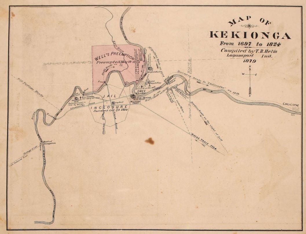
Map of Kekionga From 1697 to 1824 is on page 13 of History of Allen County, Indiana, Publication date 1880; Topics Atlas; Publisher Kingman Brothers; Collection allen_county; americana on Archive.org. History of Allen County, Indiana, with illustrations and biographical sketches of some of it's prominent men and pioneers. Also contains maps of its several townships and villages, listing farms and their owners. The Allen County Genealogical Society of Indiana has indexes to landowners and more on their Plat Maps, 1880, Allen County, Indiana page including this map.
The Forts of Fort Wayne were built across the Maumee River from Omee Village shown as the Military Tract. We have an Old Apple Tree page shown near the Omee Village on the map above.
The Miami Indian Village was at the confluence of the three rivers, now known as Fort Wayne, Indiana. The Battle of Kekionga (from HMDB Historical Marker database) in October 1790 was the fist battle fought by the United States Army after the War for Independence. The campaign had been ordered by President Washington against the Miami settlement of Kekionga, the center of Indian resistance to U.S. migration across the Ohio River. On October 17, the U.S. commander, General Josiah Harmar, reached Kekionga with 1,453 regular and militia soldiers and found that the Miami had burned and abandoned their town.
Long before this area of town was developed into farms and what we see today, the land was occupied by multiple Indian tribes living in or around Kekionga. Kekionga was the capital of the Miami Nation serving as an important center for Indian nations in the 17th and 18th centuries. Interestingly, when French missionaries first visited the area, the Miami tribe had been driven out by the Iroquois during the Beaver Wars. By the late 1600s and early 1700s, the Miami reestablished its settlement.
In the late 1700s and early 1800s, the Miami Indians signed multiple treaties after relations between the United States and the tribes became hostile. The Miami supported the British during the American Revolution, and when the British ceded the Northwest Territory, pioneers pushed west into Indiana. Due to a multitude of factors, the last civil chief of the Miami people, Jean Baptiste Richardville, signed the Treaty of St. Mary’s in 1818.
This treaty opened up much of what is Indiana to colonial settlement. For example, between 1830 and 1840, Allen County grew in population by 500%. Like most American-Indian treaties, the treaty benefited those who negotiated it more than the people affected by it. The treaty gave Richardville vast amounts of acreage South of what is today known as Rudisill Boulevard on both sides of the river. Richardville passed away in 1841, and half the Miami Indians in Indiana were forcibly removed to Kansas and then Oklahoma in October 175 years ago in 1846. The other half allowed to stay. Within the decades following, Richardville’s land was sold (both legitimately and illegitimately) and parceled off into the farms that existed before the current neighborhood developments. His house still stands on the west side of the river near Waynedale to this day.
After giving several presentations on the Battle of Kekionga and being at the old fort a couple days, I just felt inspired to go visit the site of the start of the battle...
After giving several presentations on the Battle of Kekionga and being at the old fort a couple days, I just felt inspired to go visit the site of the start of the battle...
Thanks to some fine writers at KPC News more and more people are starting to discover The Bones! We were featured in The...
Thanks to some fine writers at KPC News more and more people are starting to discover The Bones! We were featured in The Star newspaper in Auburn and the Times Pubs (you know, those free local newspapers that show up in your mailbox monthly called Northeast News/New Haven/Dupont Valley/Downtown Fort Wayne). Huge thanks to everyone who has purchased the book and if you haven't already, well then where's your civic pride? Your Fort Wayne history knowledge is not up to par! If you'd like a copy just visit bonesofkekionga.com for a list of where it's carried or you can order it right there online. Oh yeah, and if you're an eBook reader, The Bones is now available for Kindle on Amazon!

 If you'd like a copy just visit bonesofkekionga.com for a list of where it's carried or you can order it right there online. Oh yeah, and if you're an eBook reader, The Bones is now available for Kindle on Amazon!