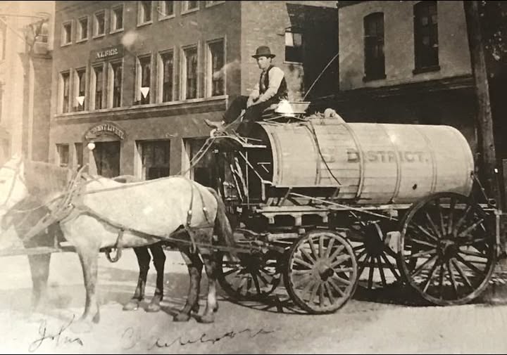
Streets of Fort Wayne, Allen County, Indiana

Sections: 1953 book Streets of Fort Wayne, Address Number Changes, Allen County Roads, Alphabetical Street List, Anthony Wayne Parkway, Brick Streets, Bridges, Murals, Street Name Changes.

The Fort Wayne Traffic Engineering Department web page has a bunch of useful maps and information worth checking out. https://www.cityoffortwayne.org/publicworks/traffic-engineering.html

Posted by Three Rivers Active Streets on Friday, March 22, 2024

Friday, March 22, 2024 post by Three Rivers Active Streets on Facebook:

The Fort Wayne Traffic Engineering Department web page has a bunch of useful maps and information worth checking out.

FW Public Works Traffic Engineering Department

[ See our Maps page for more maps ]

Unidentified Transportation Workers, Fort Wayne, 1929

A zoomable high resolution image Unidentified Transportation Workers, Fort Wayne, 1929.
Is one of over 1,000 images in the Panoramic Photograph Images at We Do History digital collection by the Indiana Historical Society.
Description: A row of workers pose with road graders and paving machinery, some horse-drawn and some gas powered, in Fort Wayne in 1929.

1910 horse drawn wagon paving crew

Street paving crew in Fort Wayne IN: showing horses with wagon, men spreading tar from the Allen County Public Library Digital Collections at the Allen County Public Library.
A question about this photo's location was posted February 22, 2024 on True Fort Wayne Indiana History on Facebook.
Brooks Construction has this same photo labeled Jackson Michigan, 1917 in a slide show on their Legacy page.

It's Wall of Fame Wednesday! Check out A.K. Hofer in 1929 as featured in the WILDWOOD PARK NEWS-LETTER.

Posted by Hofer and Davis,Inc. LAND SURVEYORS on Wednesday, March 6, 2019

March 6, 2019 post by Hofer and Davis,Inc. LAND SURVEYORS on Facebook:

It's Wall of Fame Wednesday! Check out A.K. Hofer in 1929 as featured in the WILDWOOD PARK NEWS-LETTER.

[ September 20, 1929 letter with photo shows the curing process to slow the curing of new cement in concrete streets covered with straw and wet daily ]

December 13, 2022 post by Indiana Historical Bureau on Facebook:

Have you ever complained about road work on Indiana roads? Imagine if you had to do that work yourself! On December 13, 1799, the Northwest Territory General Assembly passed the 1799 Road Law, which required signposts at important intersections, outlined road construction specifications, and dictated that all men between the ages of twenty-one and fifty must work two days per year on public roads.

Highway supervisors, who were appointed by the courts, notified all qualified men in a township three days before work was to begin. On the specified day, residents were to present themselves or a “substitute to the acceptance of the supervisor” at the given location with all required tools. If a man neglected his duty to appear or provide a substitute, he was fined 75 cents.

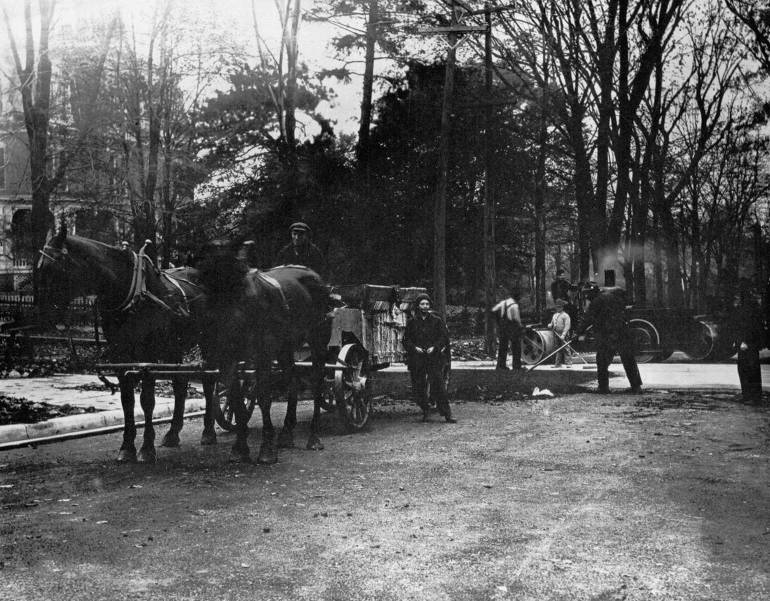
The image below, showing a road construction crew in Harrison County Indiana in the early 20th century, is courtesy of the Harrison County Public Library.

[Read about the law here: Laws of the Territory of the United States, North-west of the River Ohio By Northwest Territory, 1800 on Google books.]

2040 Transportation Plan NORTHEASTERN INDIANA REGIONAL COORDINATING COUNCIL, Adopted May 2018, Illustrations of the transportation network within the Metropolitan Planning Area. Areas include portions of Allen, Whitley, and Huntington Counties, the Cities of Fort Wayne and New Haven, and the Towns of Grabill, Huntertown, and Leo-Cedarville. At Purdue Fort Wayne.

4226 Werling Drive July 2007 Street View photo from Google Maps shows similar view of the first 2024 Facebook photo before they were torn down in 2011.
See McMillen Park Apartments Places section for more information.

January 1951 McMillen Apartments

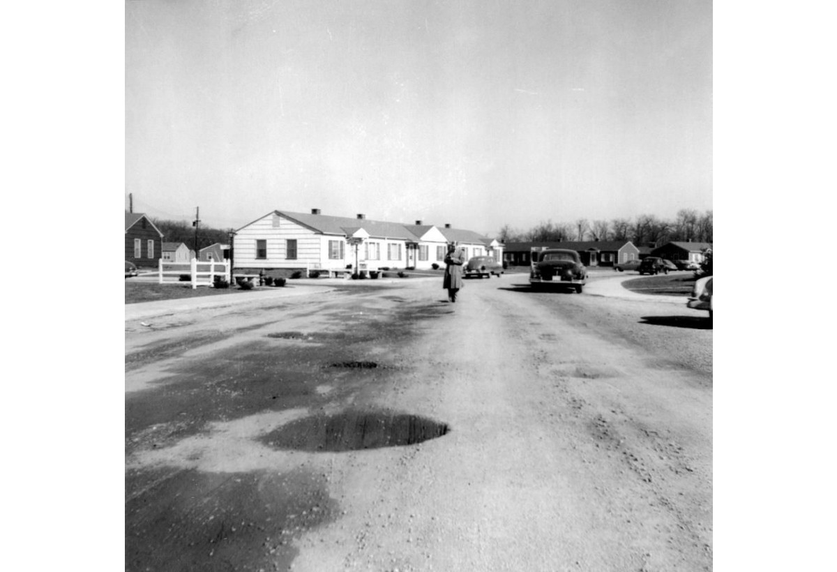
February 6, 2024 post by the library seeking photo information on True Fort Wayne Indiana History on Facebook:
Here are four photos in the Library's collection all taken in January 1951. They were taken in the Fort Wayne area, but no place was given. Does this place look familiar to anyone? I expect it is very different today if the houses are still standing.
Notice the dirt roads with pot holes in photos taken sometime after World War II when these apartments were built.

Indiana Road History

1914 Troy Dump Wagon

Troy Dump wagon spreading gravel in Fort Wayne street about 1914 in the Allen County Public Library Digital Collections at the Allen County Public Library .

This image above and two similar images with the same title: Indiana Service Corporation: showing trolley coach on road under construction facing west showing same hill on the left in the Google Street View, and Indiana Service Corporation: showing trolley coach on road under construction possibly facing east, were shared February 11, 2024 on True Fort Wayne Indiana History on Facebook asking for help identifying the 1930s location. Comments indicate it is New Haven Avenue intersection with the old 1930s cars on Fleetwood Avenue shown below:

3405 Lincoln Highway, New Haven at Fleetwood Avenue, Street View photo from Google Maps
In the 1930s photo above the dirt street Fleetwood Avenue is almost not recognized as a street except there is an automoblile on either side of the main dirt road New Haven Avenue also part of the Lincoln Highway which was also dirt roads when it was first designated as a highway. The gray house on the right is the same unpainted house in the 1930s. The houses on the left in the 1930s have been removed in the current photo and are not found in online Google photos back to October 2007 either.

Indiana’s first stagecoach route was established along Buffalo Trace (Vincennes Trace) between New Albany and Vincennes in 1820. In the 1830s, the Michigan Road (U.S. 421), Indiana’s north-south connecting route between Madison (Ohio River) and Michigan City (Lake Michigan), and the east-west National Road (U.S. 40), America’s first federally funded road, were constructed. In 1913 the Lincoln Highway (U.S. 30) was dedicated, becoming America’s first transcontinental highway. Indiana’s first interstate, State Road 420 (I-80/I-94) opened in 1952. A few years later the Federal-Aid Highway Act of 1956 created a national interstate highway system, leading to the construction of interstates such as I-74, I-465, I-65, and I-70. By this year, 97% of Hoosier households owned at least one automobile. Copied from a July 27, 2022 post by Indiana Department of Natural Resources on Facebook.

November 16, 2018 post by the Indiana Archives and Records Administration on Facebook:

Our Highway Commission collection keeps surprising us with interesting finds!

These photographs display what's possibly a road painter vehicle from the 1930s.

A comment to the original post included a newspaper article showing this vehicle: Painting the center lines on Indiana's highways from The Waterloo Press, Waterloo, Indiana, Thursday, Dec 22, 1938, Page 8

Odd Looking Vehicle

Another comment linked to a page * Updated * A Missouri State Highway Department Line Painting Detail on Route 66 at The Old Motor with a photo of this vehicle.

Page 29 above is about an 1810 law in The laws of Indiana territory, 1809-1816 by IndianaEwbank, Louis Blasdel, 1864-Riker, Dorothy Lois, 1904-, Publication date [c1934] on Archive.org and The Laws of Indiana Territory, 1809-1816 at Indiana Memory digital library at IN.gov.

Item 10 bottom of page 77 mentions males 18-50 in Indiana acts, 1816-17, 1st session by Indiana. General Assembly Publication date 1817 on Archive.org

Since early 19th century Indiana state law required males aged 18 to 50 to open and maintain public roads, it follows they would claim the road as theirs by naming it after their family labor which is why many local roads are named after the pioneer families that first settled on land bought from the United States government.

A law of 1816-17 required males age 18-50 to donate up to 6 days labor annually to open and maintain public roads. The federal government built the National Road in Indiana from 1829 to 1834. It is now U.S. 40. The Internal Improvements Act of 1836 was the state's over-ambitious attempt to address transportation needs of Hoosiers, especially for commerce and trade. Eight major projects were specified. The law resulted in financial disaster, and construction was stopped in 1839. Many projects were later completed with public and private funding. Indiana, Crossroads of America, has thirteen interstate highways--more than any other state--with a total of 1,138 miles. Copied from the Transportation page at  Introducing Indiana-Past and Presentwebpage, and Introducing Indiana-Past and Present pdf both at IN.gov.

February 24, 2023 post by The History Center on Facebook:

Traveling around Allen County and Northeastern Indiana in the early 19th century was difficult. One of the major reasons was that our portion of the state was at the western edge of the Great Black Swamp, which made roads virtually impassable. One of the solutions was the construction of plank roads. In 1847, the Fort Wayne and Lima Plank Road Company, headed by Samuel Hanna, developed Lima Road into the first plank road in northern Indiana. A plank road is constructed of a series of wooden planks laid next to each other, providing a surface over which wagons could travel in all weather conditions. When it was completed, the Lima Plank Road reached Sturgis, Michigan, a distance of 60 miles. The planks for the road were three inches thick and eight feet long. These pieces of oak are from a plank on the original Lima Plank Road, which went from Fort Wayne to Lima, now Howe, Indiana in LaGrange County. The oak plank was excavated north of LaOtto during road construction. #sociallyhistory

100 Years of INDOT Movie posted July 5, 2019 on YouTube from INDOT History page at INDOT.gov.

Hoosier motorists had hopes for easier traveling on this day in 1919 [July 27]. The newly organized state highway commission [INDOT] was busy laying out our present system of state highways. At the time, only a few stretches of highways were paved. Most were covered with gravel or crushed stone. The commission also began numbering highway routes. You had to look quickly to see if you were on the right road, though, as the route numbers were simply painted on white bands on telephone poles. Copied from a July 27, 2022 post by the Indiana Historical Society on Facebook. Short History of the Indiana State Highway Commission by J. M. Henry · 1926 on Google eBook.

Indiana License Plates Richard M. Simpson, III, 1 June 2019 at Indiana Transportation History.

Indiana License Plates, Revisited Richard M. Simpson, III, 16 March 2020 at Indiana Transportation History.

Fort Wayne Street Names

1976 Street Signs

1976 street signs in front of the old St. Mary's Catholic Church.

Street names have been listed in the Fort Wayne City and Allen County Directories since the first issue in 1858. Fort Wayne was officially built in 1794 by General Anthony Wayne at the confluence of three rivers where the Miami Indian village Kekionga already existed. Indian trails often followed animal trails and/or high ground winding and weaving along the path of least resistance around large trees, rocks, and natural obstacles in the native landscape through the primeval forest that was often year-around swamp and wetlands. Indian trails were originally foot trails that naturally enlarged over time as more people used them for horseback then wagon roads as the European settlers arrived. Some trails kept Indian names as they became roads, other roads were named for the early explorers and settlers who opened new trails, settled and/or owned the land, sometimes creating the first roads as needed along and through their land to carry on their livelihood. Roads that traverse mostly straight north-to-south or east-to-west were likely created after townships lines and maps were drawn when Allen County was formed in 1824. Early maps and history books show some early roads were toll roads with tolls collected by or paid to the land owners who created and maintained the roads. The Genealogy Center at the Allen County Public Library in Fort Wayne, Indianahas an 86-page book titled Street index of Fort Wayne, Indiana that I have not seen so don't know what is in it.

1878: A Fort Wayne Street Guide Richard M. Simpson, III, 6 July 2020 at Indiana Transportation History  contains a link to our City Directory page and has screenshots of the city directory listing the streets in 1878 Fort Wayne.

Toll Roads, and State Takeover Richard M. Simpson, III, 23 March 2019 at Indiana Transportation History.

December 1, 2021 post by the Indiana Magazine of History on Facebook:

One night in August 1900, more than two dozen men planted dynamite in a small wooden toll road house along the Lexington and Burlington Turnpike in Carroll County, Indiana, and blew it up. A sketch of the ruined building appeared two days later in the Indianapolis News. The story appeared in papers nationwide.

The destruction was part of a long-simmering dispute among county officials, business owners, and farmers over private toll roads and the authority of local governments. Read the whole story of the Toll Road War in Bruce Monroe's "The Lexington and Burlington Turnpike and Indiana's Toll Road War," in the September 2019 issue of the Indiana Magazine of History, available free online through IU ScholarWorks: 

The Logansport and Burlington Turnpike, and Indiana’s Toll Road War [ Abstract On April 3, 1900, a mob of masked men blew up a toll house along the Logansport and Burlington Turnpike in Carroll County, Indiana. The story made news across the state and the nation. Bruce Monroe examines how a fourteen-mile “local road” turned into “a weapon in the commercial rivalry” between two towns in western Indiana. Across the Midwest in the late nineteenth century, toll roads—many built by counties to allow farmers better access to local markets—gave way to free gravel roads, railroads, and, by the turn of the century, interurban lines. The competing interests of county commissioners, business owners, developers, farmers, and taxpayers created disputes that played out in local newspapers and sometimes issued in violence. ]

Below, the sketch from the Indianapolis News, August 23, 1900.

Address Number Changes

Early city street names and addresses changed over time as the city and county developed, including number changes in 1902 and can be found in the city directories and newspaper articles. One example is the John Sollberger saloon at 232 W. Main in 1900 and 1901 but at 916 W. Main in 1902. As the early town expanded, streets with one name were often connected with existing county roads that already had names. Some street names changed over time as they were extended and merged with other existing streets, and/or sometimes eliminated when buildings were torn down or expanded, and bridges were built over creeks, rivers and low flood plain land not possible without modern technology in the pioneer days. Different government jurisdictions of city, county, and township can also create naming conflicts. Finding maps for the years street names were used co-ordinated with the same city directory years should help determine the location of older street names. The 1953 book Streets of Fort Wayne shown below could also help. See the September 26, 2017 discussion on You are positively from Fort Wayne, if you remember... Archived group only visible to existing members on Facebook.

Street Name Changes

Page 6 of the online book History of the Fort Wayne Fire Department : extracts from Fort Wayne, Indiana, newspapers by Weber, Donald Allen states: Listed below are the names of some of the streets taken from the newspaper articles that have been changed since that time. The new names as we know them today are also listed. Water Street is now — Superior Street. George Street is now — West Brackenridge Street. Hamilton Street is now — Masterson Street. Dawson Street is now — Williams Street. Holman Street is now — East Brackenridge Street. Montgomery Street is now — East Douglas Street. Griffith Street is now — Fairfield Avenue. Duryea Street is now — Poplar Street. Pritchard Street is now — Lavina Street. Erie Street is now — East Berry Street. Thomas Street is now — Bowser Avenue. Walton Avenue is now — Anthony Blvd.

Fort Wayne Daily News of 9 December 1897 article “The Names of Many of Our Thoroughfares to be Changed Next Month.” stated: “Last night the committee on streets and rules and regulations, a special committee appointed to change the names of all streets and avenues where the same name appears twice in the city streets, met and concluded it labors. Several new streets were names and some streets and avenues which were continuous or extensions of other streets, all experience changes of names.” from Fort Wayne Street Name Changes by Richard M. Simpson, III,10/19/1967 – 01/22/2021, 7 July 2020 on Indiana Transportation History. His article 1878: A Fort Wayne Street Guide is based on our City Directories of Fort Wayne page.

Street name changes create confusion for genealogy researchers and modern travelers and can lead to lively discussions on social media such as the December 30, 2018 discussion on You are positively from Fort Wayne, if you remember... Archived group only visible to existing members on Facebook. At first it would seem easy to just change a street or road to one name. It is easy if no one has a business or home address recorded anywhere using the existing names and addresses. As any long-time genealogist soon learns, it is not unusual to have that one ancestor who seems impossible to locate until the researcher discovers that the ancestor lived somewhere for a long time without moving, but the government entity whether township, county, or even state boundary lines moved because of early survey or border line disputes that were settled once and for all in a court settlement during or even after their lifetime. Documentation for that ancestor will then be found in whatever government archive entity that claimed jurisdiction over their land for that specific time period. Modern street name changes create similar complications and potential expenses. Costs start with changing street signs, contacting mapping entities whether print or digital, billing and delivery problems can occur for address changes with the post office, various government agencies, package delivery companies, even long ago contacts that use old addresses until made aware of name changes resulting in undelivered items and unintended consequences. These potential costs and complications often lead to simply leaving the existing street names to avoid complications not worth the expense and grief of making those changes.

If you find sources of reliable documentation of local street names and address changes please Contact Allen INGenWeb.

October 7, 2015 post by Hofer and Davis, Inc. Land Surveyors on Facebook:

TA DA!!! It's Wall of Fame Wednesday!!! Come on down to 203 W. Wayne Street Suite 316 to check out this vintage wooden street sign [Lafayette ] found in the garage attic of company founder A.K. Hofer! It's an experience you will never forget, and we will get your picture!

Maps

1930s Transit Map  for any Direction in Fort Wayne by Street Car, Trolley Coach, Motor Bus

A 1930s era zoomable map: Transit Map for any Direction in Fort Wayne by Street Car, Trolley Coach, Motor Bus is in the Maps in the Indiana Historical Society Collections at We Do History digital collection by the Indiana Historical Society.

Construction

Brooks Construction Legacy History

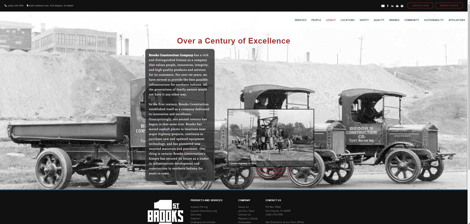
Brooks Construction first paving job on existing dirt and gravel roads was in 1909 when John Foster Brooks convinced the City of Fort Wayne to construct Forest Park Boulevard using asphalt. Brooks Construction got its first big break when the Indiana state legislature passed a "three mile law" to encourage the construction of roads between communities. Doing all work by hand or with horses and steam driven pavers, Brooks Construction constructed a three mile stretch of concrete road between New Haven and Fort Wayne. This was the first concrete road in Indiana and is known as Old Maumee Road today. Their website has a slide show of early paving photos on their Legacy page. A Brief History of Brooks Construction Company, Inc. five page document discusses construction of the first paved streets with concrete, asphalt, and brick starting in 1909.


The Three-Mile Road Law - Its Uses and Abuses 4 page section starting on page 154 of the Purdue Engineering Extension Department Eighteenth Annual Road School at Purdue.edu. 

Alphabetical Street list

Here is an incomplete list of streets found online.

  1. Auto Trails from Fort Wayne by Richard M. Simpson, III published 15 April 2020 on Indiana Transportation History.com.
  2. Streets of Fort Wayne by McCoy, Angus CameronPublic Library of Fort Wayne and Allen County, Publication Date 1953, on Archive.org.
    from "a speech before the Quest Club, November 30, 1945," prepared by the staff of the Public Library of Fort Wayne and Allen County. The Streets of Fort Wayne. McCoy Angus M-No Date-0001 is also viewable online in the Quest Club Papers in the Allen County Public Library Digital Collections at the Allen County Public Library.

    Streets of Fort Wayne by McCoy, Angus CameronPublic Library of Fort Wayne and Allen County, Publication date 1953 on Archive.org

  3. Crossroads of History: Paving through Fort Wayne's Streets by Joshua Schipper published August 8, 2020 is an update of the 1953 book above. Also has a Facebook page Fort Wayne Road Commission - FWRC and a newspaper article interviewed the twenty-year-old author in On road to finding answers City man writes book on whys of streets' names by Blake Sebring published February 2, 2021 in The Journal Gazette newspaper.
  4. Street Scene Series 9 short videos filmed in the 1970s by a librarian at the Allen County Public Library posted on YouTube and 7 similar but longer videos on Access One of the Access Fort Wayne public television at the Allen County Public Library. The Street Scenes and Fort Wayne Landmarks series' as an attempt to preserve the flavor of some of the older, mainly residential areas of Fort Wayne. Series 2 consists of wide-angle views taken from a car moving slowly through the designated areas. Camera and Editing by Steve Fortriede. 3 videos are found below, the others are elsewhere on our site. We had an interesting discussion with Alan Bengs on these old videos February 26, 2019 on You are positively from Fort Wayne, if you remember... Archived group only visible to existing members on Facebook.

    Fort Wayne Street Series: March 1974 58 minute video by Access Fort Wayne
    at the Allen County Public Librarypublished on November 23, 2015 on YouTube
    A rare and interesting time capsule showcasing what the area used to look like! Raw footage of architecture and businesses on Calhoun and Broadway circa 1974 as seen from the sidewalks. Originally shot and submitted by Steven Fortriede on 3/4 tape.

  5. What’s in a (street) name?
    By Randy Harter
    Fort Wayne Reader
    2018-06-01

    While the origins of some Fort Wayne street names have been lost to history, others have been recorded and passed down. We’ll take a little hike through the city center, north from Main, south from Main, west from Calhoun and finishing up east from Calhoun to find out what’s in a name.

    Heading north from Main is Columbia Street, named not for Christopher Columbus, but rather for canal boat captain and Columbia Street hotelier, Dana Columbia. Next is Superior (formally called Water), named for Lake Superior.

    Moving south from Main, Berry Street is first and named for Indian Sub-Agent Benjamin Berry Kercheval. Next, well this one is about as easy as it gets: Wayne is named for Isaac and Elizabeth’s son Anthony whose bronze likeness sits astride its steed in Freimann Square. Moving on south we have streets named for the first, third and fourth presidents, Washington, Jefferson and Madison. Next, Lewis Street was named for the Commissioner of the local Land Office, Major Samuel Lewis, who was appointed by President John Quincy Adams in 1827. Moving further south, we come to Douglas, so named for Stephen Douglas who stumped here for President in 1860 but ultimately lost to Abraham Lincoln.

    Heading back to Main, Calhoun Street is the east-west dividing point in Fort Wayne and named for John C. Calhoun of South Carolina, the Vice President under President’s John Quincy Adams and Andrew Jackson. Harrison is next to the west and commemorates William Henry Harrison, the Governor of the pre-statehood Indiana Territory (1801-1812) and the country’s ninth President. Maiden Lane (like Pearl Street) is a nod to New York City’s Wall Street financial district. Like our Maiden Lane, New York’s also “T’s” into its Pearl.

    Next, Webster honors Senator Daniel Webster from New Hampshire. After Webster is Ewing Street named for the Ewing family, the patriarch of which was Colonel Alexander Ewing. We’ll finish going west with Fairfield Avenue, named for sea captain Asa Fairfield from Maine who arrived here in 1833 and operated the first canal boat on the Wabash & Erie Canal.

    Back to Calhoun and Main, the first street to the east was Court. This one-block long street running on the east side of the courthouse was eliminated in the late 1990’s with the creation of the Courthouse Green. Next is Clinton Street named for DeWitt Clinton, governor of New York, who was largely responsible for the construction of the 363 mile long Erie Canal connecting the Hudson River with Lake Erie.

    Barr is next in line and was named for John T. Barr of Baltimore who along with John McCorkle of Piqua, Ohio purchased all of the original downtown plat for$2,838.43 when it was put up for sale by the Federal Government in 1823. This land ran from today’s Superior Street, south to Washington and from roughly Barr Street west to Calhoun, about 14 square blocks of woods, dirt paths, stumps and swampland.

    On to Lafayette Street named for French general, Marquis de Lafayette who had assisted George Washington during the Revolutionary War. We’ll finish with one more block and so include Clay Street (named for Senator Henry Clay of Kentucky), which is really the beginnings of Fort Wayne as it was at the northwest corner of Clay and Berry that Anthony Wayne built his fort over a five week period during September and October of 1794.

    The panoramic map was drawn by a group of German artists in 1880 the last year there was still water in the canal through downtown. By the end of 1881 this portion of the canal had been filled in and railroad tracks (now Norfolk Southern’s) laid atop it.

    A tip of the hat each to the late James M. Schaab, and Angus C. McCoy for their individual
    research and writings regarding our streets.

    Randy Harter is a Fort Wayne historian, author and the history/architecture guide for FortWayneFoodTours.com

  6. An Early Road: Fort Wayne to Tiptonsport about John Tipton in early 1800s by Tom Castaldi published March 8, 2016 in History Center Notes & Queries blog.
  7. 1940s photo of Johnny Appleseed Bridge looking northeast before IPFW campus was built discussion March 23, 2017 on the original Great Memories and History of Fort Wayne, Indiana page on Facebook.
  8. 'Auto Indiana' exhibit rolls into The History Center mentions motorists from 1905-1912 made their own license plates and shows a 1914 car accident by Kevin Kilbane published September 12, 2013 in The News-Sentinel newspaper.
  9. October 2022 the 800 block of Berry Street was renamed “the Terrance Miles Memorial Parkway” to honor the 36-year-old man killed in 2017. The family says what made Terrance a great person was how he mentored and encouraged young people in the community. They say that he was passionate about coaching youth football and mentoring kids at the Boys and Girls Club. Copied from New memorial honors Fort Wayne man shot and killed in 2017 by Alex Null published October 20, 2022 on WKJG NBC. For what would have been Terrance Miles’ 41st birthday Thursday, more than 50 people gathered at the house where he grew up to see how Fort Wayne honored his legacy as a mentor. A sign at the Harmar Street intersection now designates the block of Berry Street going west as Terrance “Money” Miles Memorial Parkway. His father, Lynn Dandridge, unveiled the sign during a short ceremony. “It keeps my son’s legacy going,” Dandridge said afterwards. “He loved the kids, and the kids loved him.” Terrance Miles was a Forest Park Elementary School administrative assistant and assistant North Side High School football coach when he died May 19, 2017, during an alleged armed robbery attempt. He was also a Metro Youth Sports football coach and active with the Boys and Girls Clubs of Fort Wayne. Copied from Newly designated parkway keeps alive the name of a youth mentor James D. Wolf Jr. published Oct 21, 2022 in The Journal Gazette newspaper.

    January 31, 2024 post by the Genealogy Center on Facebook:

    It's #waybackwednesday! These images come from the Daniel A. Baker Collection in our Community Album, showing Berry St. looking east, downtown Fort Wayne. 📸 [ Old Anthony Hotel is visible on the left photo taken at the corner of Berry and Harrison Streets - see Street View on Google Maps ]

    View more images in the collection here: http://contentdm.acpl.lib.in.us/

  10. Broadway and Taylor intersection. Meyer's, Mad Anthony photo and discussion March 29, 2017 on You are positively from Fort Wayne, if you remember... Archived group only visible to existing members on Facebook.
  11. Broadway Avenue - photos of 1014 discussed September 13, 2017 on You are positively from Fort Wayne, if you remember... Archived group only visible to existing members on Facebook.
  12. June 8, 2023 post by ARCH, Inc. on Facebook:

    Drive south on Broadway Avenue and you will find this wonderful example of an unaltered 19th century Queen Anne/Neoclassical Commercial building, circa 1890. The building still has the original storefront windows, doors and recessed oriels. Most windows have flat arched bonded brick and stone sills. The roof features a stepped brick parapet with stone coping, brick chimneys and projecting wood cornice. A modern cloth awning and lights have been installed along the front, beneath the wood frieze and projecting cornice. It was once the drugstore of Carole Lombard’s uncle. As a child, Lombard liked to visit and drink a soda. It has housed many different businesses, including Chappell’s Seafood Market and Coral Grill restaurant, and currently is home of Trubble Brewing. ARCH is proud to present this edition of Throwback Thursday, part of its work as the historic preservation organization serving the greater Fort Wayne area, made possible by ARCH members and donors. Thank you.

  13. Burgess Street July 8, 1916 Fort Wayne Weekly Sentinel article about Francis Burgess, the machinist, here 60 years today from Great Memories and History of Fort Wayne, Indiana.
  14. Calhoun Street: on page n16 of the 1953 book Streets of Fort Wayne it states: National figures whose names hold undiminished interest are recalled In the naming of many streets, such as CALHOUN STREET, HARRISON STREET, CLINTON STREET (named for DeWitt Clinton, pioneer in the movement for the construction of the Erie Canal), and FRANKLIN AVENUE. Page n18 states: The first plat of the city of Fort Wayne was laid out in 1824 by John T. Barr and John McCorkle. It contained one hundred and eighteen lots, with three streets (Clinton, Calhoun, and Barr) running north and south and five (Wayne, Berry, Main, Columbia and Water, which was later renamed Superior) running east and west.

    February 7, 2024 post by the Genealogy Center on Facebook:

    It's #waybackwednesday! Take a look at this 1889 scene of Calhoun Street! This photo features several businesses including Mommer Dentist, Sites Dentist, a drug store, clothiers, and a watch retailer. What do you see?

    Explore this photo and more in our Community Album: http://contentdm.acpl.lib.in.us/

    1. Calhoun Street – The Gathering Place a webpage of photos from the Community Album courtesy of the Allen County Public Library on Open Streets Fort Wayne by City of Fort Wayne. Some of these photo were included in eighteen photos posted September 22, 2023 on True Fort Wayne Indiana History on Facebook.
    2. During the BLM, Black Lives Matter era, an interesting newspaper article looked at the history of John Calhoun. John Calhoun boasts an impressive list of political accomplishments. Following nearly 15 years in the U.S. House, he served as President James Monroe's secretary of war from 1817-25. Calhoun was later chosen as America's seventh vice president, serving from 1825-32, first under President John Quincy Adams, then President Andrew Jackson. Following the end of his vice presidency, Calhoun served in the U.S. Senate for a dozen years until he was appointed secretary of state under President John Tyler from 1844-45. Calhoun returned to the Senate for five additional years until he died in 1850. While spending most of his adult life in government, Calhoun developed a strong advocacy for state's rights during our country's westward expansion in the 1800s. Copied from: Calhoun, reconsidered Let's change street name with racist namesake by local high school history teacher Chris Elliott published September 09, 2020 in The Journal Gazette newspaper.
    3. Why not simply but sincerely rededicate our Calhoun Street from the slave-owning John C. Calhoun to his family’s freed slave Moses Calhoun? Instead of renaming our streets, let's find other worthy honorees Floyd Guffey March 30, 2023 in The Journal Gazette newspaper.
    4. Calhoun Street – The Gathering Place Calhoun Street has changed over the past 200 years with respect to technology and the people who use it, but in many ways it is the same busy and bustling street. One of the earliest accounts of Calhoun Street is from the 1820s when the now paved roads, were made of dirt. Today Calhoun Street is still a place where residents of all backgrounds gather, eat, shop, and enjoy the spirit of Calhoun Street. Copied from Open Streets Fort Wayne by City of Fort Wayne.
  15. Canal Hotels on Rosemarie Alley by Tom Castaldi posted February 27, 2014 on the History Center Notes & Queries blog.
  16. Circumurban was constructed in the 1950s-early 1960s around the north side of Fort Wayne. See Fort Wayne at AARoads. A couple of 100+ page documents: January 17, 1978 Administrative Action draft Fort Wayne Circumurban Route Proposed Development, US-30 to I-69, Allen County: Environmental Impact Statement (preview) and slightly different June 24, 1983 Administrative Action final Fort Wayne Circumurban Route Proposed Development, US-30 to I-69, Allen County: Environmental Impact Statement (preview) 1983 at Google eBook. Indiana State Road 930 at Wikipedia, The Free Encyclopedia

    April 1, 2014 post by Hofer and Davis, Inc. Land Surveyors on Facebook:

    Picture from News Sentinel 1926. Caption below reads: PLAN CIRCUMURBAN WAY- Mayor Geake, and City Planning Commission party, are shown watching City Civil Engineer Randall illustrate how Circumurban Way would cross Maumee river at Meyer-Reed road (Meyer was renamed to Maplecrest Road). Left to right: William C. Geake;mayor; Frank M. Randall, city civil engineer; Frank Schramm, member of commission; A.K. Hofer, civil rengineer, whose services are furnished to survey route of proposed traffic way by the Kiwanis club; Robert B. Hanna, consultant of commission; Miss Agata Diek, secretary, and Mrs. O.N. Guldlin, James Haberly, Herman F. Gerdom, and W.C. Dickmeyer, member of commission.-News-Sentinel Staff Photo.

    April 1, 2023 share to True Fort Wayne Indiana History on Facebook on Facebook:
    That’s my grandfather, A.K. Hofer with plans for the Circumurban as pictured in the News-Sentinel in 1926.

    I’m not sure when it was built and checked historical imagery on the GIS, somewhere between 1938 and 1957, the year I was born.

    At least 13 years after the plans were donated from the Kiwanis Club.

  17. June 15, 2017 post by Hofer and Davis, Inc. Land Surveyors on Facebook:

    CIRCUMURBAN PROPOSAL from the August 21, 1962 Fort Wayne Journal-Gazette. This is a proposal for the triangle bounded by Hobson, Trier and the Circumurban a.ka. The Bypass. Think Don Hall's Triangle Park, formerly Holly's Landing! It obviously was an architects vision! BTW....Hofer and Davis, Inc. did the boundary survey in January of 1962, and many surveys since!

    The Community at Triangle Park occupies the tall building in 2022.

    Photo shown above is from their photo album: 1926 CIRCUMURBAN HIGHWAY FROM THE "SCRAPBOOK" AT HOFER AND DAVIS,INC. LAND SURVEYORS on Hofer and Davis, Inc. Land Surveyors on Facebook.

  18. October 8, 2015 post by Hoch Associates on Facebook:

    Yes, Clinton Street used to be a two way street in this #TBT. Hard to believe now as you travel south at the intersection with Superior, but this was the original gateway into Downtown Fort Wayne..looks a little different huh? Imagine trying to cross the street during Three Rivers Festival if it was around then.

  19. October 7, 2013 post by the original Great Memories and History of Fort Wayne, Indiana page on Facebook:

    The first cloverleaf in Fort Wayne, linking U.S. Highways 24 and 30 with Coliseum Blvd., is nearly complete in this May 27, 1958, aerial photo. The new interchange is expected to help traffic flow to and from the city's east-end industries

  20. College Street - the Methodist College founded in 1846 stood at the west end of West Wayne Street fronting College Street. See lithograph published December 22, 2014 on Save Our Fort Wayne History.
  21. Columbia Street

    August 10, 2018 post by The Landing Fort Wayne on Facebook:

    Dana Columbia—he's where Columbia Street gets its name from. He was a canal boat operator, and his boat was the first to carry passengers along the Wabash and Erie Canal from Fort Wayne to Lafayette.

    — feeling cool.

    June 1974 Fort Wayne Street Scenes --Columbia Street West posted November 11, 2016 by the Allen County Public Library YouTube. June, 1974. Columbia Street north side 100 block west, 4. Columbia Street south side 100 block west. Street Scenes Wide angle views, then detailed studies, building by building, of the older portions of Fort Wayne. Camera and Editing by Steve Fortriede.
  22. June 20, 2018 post by The Landing Fort Wayne on Facebook:

    [Columbia Street history sign] — at The Landing Fort Wayne.


  23. The Columbia Street story (1975) - Bates, Roy M on Archive.org

  24. Around 540 East Columbia Street Street View photo from Google maps
    Sculpture latest example of public art in downtown Fort Wayne November 13th, 2018 on NEI Northeast Indiana


    May 10, 2020 post by Silva Lining Photography on Facebook from his Fibonacci Series album.
  25. Covington Road is probably named for the Covington Homestead family whose history remains unknow in 2020.
  26. Dock Street - How The Landing and Dock Street Got Their Names (It's for the Same Reason) by Shane G. posted August 10, 2012 on Visit Fort Wayne blog. Dock Street resembles an alley along the elevated Nickel Plate Railroad tracks one block between South Harrison and Calhoun Streets on the north side of the buildings on The Landing. See Street View photo at Calhoun and Dock Streets on Google maps. Dock Street is briefly mentioned in the 1953 Angus McCoy book on page 32 and slightly longer discussion in the typed 11-30-1945 Quest Club version in a 3-ring binder on page 24 of the The Streets of Fort Wayne by Angus McCoy in the Allen County Public Library Digital Collections at the Allen County Public Library.
  27. George Street - on Broadway, named for Mother George, became Brackenridge Street at some point in time. Fort Wayne maps of both 1874 and 1895 show a street named for her that later was changed to West Brackenridge. According to Harold Lopshire at ARCH, a grocery store building was erected in 1864 by Joseph Nohe at the corner of Broadway and George Street. Today, along Broadway there is no longer any evidence of a street celebrating the memory of Mother George except a marker embedded high on the building wall of the once grocery store, now carpet retailer, that reads, “George St.” To honor the memory of Eliza George, however, a marker was placed on the north side of East Berry Street between Barr and Lafayette that is near the site of her first home in Fort Wayne. It was erected in May of 1965 by the Fort Wayne Civil War Roundtable. Copied from a longer Comment to a photo street names on the building posted and discussed September 9, 2018 on You are positively from Fort Wayne, if you remember... Archived group only visible to existing members on Facebook.
  28. GOSHEN AVENUE IMPROVEMENTS PROJECT RECEIVES PROJECT OF THE YEAR AWARD May 20, 2022 on City of Fort Wayne - Known for decades as “Five Points,” the intersection of Goshen Avenue, Sherman Boulevard, and Lillian Avenue is part of the historic Lincoln Highway. Before improvements, the signal-controlled intersection had no pedestrian access, no lighting, poor drainage, long traffic delays, and a history of accidents. The City of Fort Wayne’s Goshen Avenue Improvements Project received the 2021 APWA-Indiana Chapter Public Works Project of the Year in the Transportation category. The $5.3 million Goshen Avenue Improvements Project features a roundabout that improved traffic flow, incorporated pedestrian traffic, and revitalized the neighborhood, including new lighting, an enclosed drainage system, consolidation or removal of multiple access points, and pedestrian friendly walkways along the roadway. The intersection at the roundabout welcomes approximately 18,500 vehicles per day. With the continuous traffic flow from cars no longer stopping at lights, emissions from idling cars is estimated to be reduced by 20%.
  29. Hanna Street - a May 14, 1898 Fort Wayne News newspaper article about cedar block replacement posted May 13, 2017 on the original Great Memories and History of Fort Wayne, Indiana page on Facebook.
  30. I-469 bypass opening ceremony was October 23, 1995. I-469 - Fort Wayne and I-469 Construction Overview on IN.gov. Statistics on Project: Fort Wayne, Indiana, I-469 Beltway on EconWorks. Interstate 469 on Wikipedia, The Free Encyclopedia.
  31. When the idea of a bypass of Fort Wayne was floated, the idea was create a bypass removing US 24 and US 27 from the downtown area. The location of the new bypass would route both of those US routes far outside the bounds of the city. Most of the new bypass would be built outside the distant city limits. The bypass would be constructed starting at Lafayette Center Road southwest of the city at I-69. The first section of the route would be built from that point to connect to US 30 east of New Haven, a distance of 19 miles. The contracts were let for this project starting 12 June 1984. Copied from longer article Fort Wayne Bypass by Richard M. Simpson posted 30 June 2020 on Indiana Transportation History.
  32. Killea Street

    KILLEA STREET. YEAR?

    Posted by Indiana News 1 on Thursday, March 24, 2011

    Thursday, March 24, 2011 post by Indiana News 1 on Facebook:

    KILLEA STREET. 1950s automobiles

  33. Lafayette Wood Street Signs Old wood street signs from A.K. Hofer's garage photo album at Hofer and Davis, Inc. Land Surveyors on Facebook
  34. Ludwig Road roundabout photos posted December 7, 2022 by City of Fort Wayne Government on Facebook.
  35. Main Street
    Fort Wayne Street Scenes---Main Street, Southside posted November 11, 2016 by the Allen County Public Library on YouTube.
    October, 1976, Main Street south side 1900 block - 400 block west. Originated as a complement to our original Street Scenes and Fort Wayne Landmarks series is an attempt to preserve the flavor of some of the older, mainly residential areas of Fort Wayne. Series 2 consists of wide-angle views taken from a car moving slowly through the designated areas. Camera and Editing by Steve Fortriede.
    Fort Wayne Street Scenes---Main Street, Northside posted November 11, 2016 by the Allen County Public Library on YouTube.
    October, 1976. Main Street north side 200 block - 1900 block west. Originated as a complement to our original Street Scenes and Fort Wayne Landmarks series' as an attempt to preserve the flavor of some of the older, mainly residential areas of Fort Wayne. Series 2 consists of wide-angle views taken from a car moving slowly through the designated areas. Camera and Editing by Steve Fortriede.
  36. Maplecrest Road, formerly Meyer Road. Maplecrest was originally called Meyer Road for Herb Meyer. Herb Meyer had a connection with St. Peters Lutheran church history from a streets and roads discussion about the Fort Wayne Road Commission new book on local streets April 22, 2020 on You are positively from Fort Wayne, if you remember... Archived group only visible to existing members on Facebook. The Maplecrest Road Extension Fort Wayne, Indiana opened October 30, 2012. Mark Souder Indiana House of Representive was a strong advocate for federal funding of this project. American Structure Point, Inc. with photos describes it as: This 1.5-mile roadway extension project included design of a new 4-lane roadway section with curb and gutter through a highly industrialized urban area. The project incorporates grade separations over two railroad facilities, one industrial supplier, two roadways, and the Maumee River. Additionally, the project included design of new storm sewers, sidewalks, traffic signing, and three at-grade intersections, including two traffic signal designs. This project played a major role in improving the transportation mobility for Allen County and the cities of Fort Wayne and New Haven. Maplecrest Road Extension to Open Oct. 30 that was on www.allencounty.us states: The event’s theme — “ Connecting Communities” — will celebrate the collaborative effort of Allen County, the cities of Fort Wayne and New Haven, and state and federal officials to make the Maplecrest Extension a reality. The project extends Maplecrest from Lake Avenue to Adams Center Road at Indiana 930 in New Haven. It features construction of 1.5 miles of new four-lane roadway with curb and gutter and four new bridges. It also includes design of new storm sewers, a multi-use trail, traffic signing, and three at-grade intersections, including three traffic signal designs. Work began in the spring of 2010. Primco, Inc. of Fort Wayne was awarded the construction contract. To date, approximately $31.4 million has been spent on the project. The engineer’s original estimate was just under $50 million. November 2, 2012 dedication of the Maplecrest Road Extension with four bridges crossing 2 railroad tracks creating a north south corridor on the east side of Fort Wayne connecting Fort Wayne with New Haven and Adams Center Road on the south. Both roads intersect the I-469 bypass that loops around southern and eastern Fort Wayne with I-69 on the west. Maplecrest insects I-469 on the north, Adams Center intersects I-469 on the south. It was the "most complex road project that has been undertaken locally ... cost $31.4 million, well below the engineer’s original estimate of $50 million, [Linda] Bloom said. The new road will provide easier access to the Norfolk Southern railroad office and the Do it Best headquarters and will do away with two railroad crossings." from Maplecrest extension touted as link for two communities by Vivian Sade published November 3, 2012 in The Journal Gazette newspaper. "More than a decade ago, Allen County Commissioner Linda Bloom found undeveloped plans from 1970 for building a north-south corridor on the east side of Allen County." From Maplecrest extension finishes long journey also by Vivian Sade published October 29, 2012 in The Journal Gazette newspaper. See Maplecrest Road Extension by Beth Stauffer on The New Haven Bulletin. The road names remain unchanged after crossing bridge. Access Fort Wayne at the Allen County Public Library had a 30 minute Countyline video about the Maplecrest Extension including speeches at the dedication.

    Quite a contrast from the early 1960s dirt road only used by farmers as the population was moving northeast.

    November 19, 2020 post by the City of Fort Wayne Government on Facebook:

    A commitment to neighborhoods.

    Today, Mayor Tom Henry joined residents and local businesses to celebrate street and sidewalk improvements on Maplecrest Road.

    MAYOR HENRY LEADS RIBBON CUTTING EVENT TO COMMEMORATE COMPLETION OF MAPLECREST ROAD NEIGHBORHOOD INFRASTRUCTURE IMPROVEMENT PROJECT October 21, 2015

  37. Metaform mural video by Tobias Studios along Columbia Street in downtown finished and posted September 14, 2017 posted by the City of Fort Wayneon Facebook.
  38. McClellan Street is in southern Fort Wayne between Pettit Avenue and Paulding Road. Photographs by David and Peter Turnley taken in 1972-73 on their website McClellan Street and a book by the same name refer to McClellan Street downtown by Parkview Field that is now parking lots.
  39. Miss Virginia Memorial Parkway - named for philanthropist Miss Virginia Schrantz, the founder of the Miss Virginia Mission House at 1312 Hanna St. Originally from Part of Hanna Street to be named after Miss Virginia published June 3, 2015 and Street dedicated to woman who left mark of kindness published June 4, 2015 both redirected to a March 16, 2016 update of second article by Dave Gong in The Journal Gazette newspaper.
  40. Old Mill Road - Street View photo of street sign from Google maps.

    In 1827 Barnett and Hanna built a small dam in the St. Marys and downstream erected a mill just south of the over the river (near today's Sears Pavilion). Old Mill Road was later named after this mill, and the bridge that carried the Indianapolis State Road (Broadway, today) across the river to the Little River Turnpike, or Bluffton Road, was the principle southern route out of Fort Wayne.  From South Wayne area was once a city unto itself by Michael Hawfield fromCityscapes - People & Places series of articles from the archives of The News-Sentinel newspaper.

    OLD MILL ROAD is a continuation of Broadway and was so named because it is substantially along the old trail which the pioneers used in coming from Decatur to the old mill, once located near the present Oakdale bridge. From page n14 in Streets of Fort Wayne by McCoy, Angus CameronPublic Library of Fort Wayne and Allen County, Publication date 1953 on Archive.org.

    The first water-powered mill erected in Allen County was completed in August, 1827, by James Barnett and Samuel Hanna. The mill stood on the left bank of the St. Marys River, a short distance south of the present Oakdale Bridge (State Roads 1 and 3) in what is now Foster Park. It was located in the southeast quarter of Section 15, Wayne Township and at the time of its erection was several miles from the village of Fort Wayne. From page 18 in The water-powered mills of Allen County, Indiana by Bates, Roy M. on Archive.org.

    A January 13, 2023 conversation on True Fort Wayne Indiana History on Facebook included a comment by Creager Smith a Historic Preservation Planner at City of Fort Wayne Government stating: The mill site was used through much of the 1800s, although at least one mill was destroyed by fire. I believe the last operating mill there was c.1880. The stone "rapids" between roughly Foster Park and Sears Pavillion are what's left of a mill dam. There was a mill race that diverted water to beneath the mill, where the flowing water turned a turbine that powered the mill. The race and the mill were on the Bluffton Road side of the St. Marys.

  41. Oxford Street - How a new community resting park came to life in South East Fort Wayne’s Oxford neighborhood by Julia Hanauer posted December 7, 2022 in Input Fort Wayne from their December 7, 2022 post on Facebook.
  42. Pontiac Street

    December 15, 2022 post by the City of Fort Wayne Government on Facebook:

    This evening, Mayor Tom Henry, city officials and neighborhood leaders celebrated the completion of the Pontiac/Wayne Trace Roundabouts Renovation & Beautification project.

    Read more: RIBBON CUTTING CEREMONY CELEBRATES RECONSTRUCTION OF ROUNDABOUTS TO CREATE ENTRYWAY INTO THREE SOUTHEAST COMMUNITY NEIGHBORHOODS

    Fort Wayne holds ribbon-cutting ceremony for southeast roundabout renovations by Clayton McMahan, posted December 15, 2022 at CBS WANE-TV NewsChannel 15. The Pontiac Street/Wayne Trace Intersections has aerial photos showing roundabouts on either side of the railroad tracks by American StructurePoint Inc. Completion of roundabout improvements on Fort Wayne’s southeast side was celebrated Thursday with a ribbon-cutting. City officials hailed the Pontiac/Wayne Trace Roundabouts Renovation & Beautification Project as a major improvement to a difficult area along the Coliseum Boulevard/Pontiac Street corridor, making it not only safer but more aesthetically pleasing. The corridor is used by residential and industrial traffic and carries nearly 16,000 vehicles a day, officials said in a news release. The area has had two roundabouts since 2002, but because of the heavy traffic, they had sustained center island ruts, a damaged monument and damaged and ill-maintained landscaping. Improvements include increased land widths making it easier for large vehicles to turn, landscaping of the center islands and artwork in the form of three towers in each island. The center islands were landscaped and brush was cleared along a railroad right-of-way. A railroad bridge now has decorative steel facades to note entry to the three large neighborhoods on either side of the railroads – Greater McMillen Park, Eastside Community and Harvester Community. Bridge abutments and handrails were painted and colorful lighting was added under the railroad bridge and to illuminate the towers. Copied from Roundabouts see improvements on Fort Wayne's southeast side by Rosa Salter Rodriguez posted December 16, 2022 in The Journal Gazette newspaper.

    April 21, 2023 post by City of Fort Wayne Government on Facebook:

    The Pontiac/Wayne Trace Roundabout Renovation & Beautification Project earns Excellence in Construction Award.

    Read more: PONTIAC/WAYNE TRACE ROUNDABOUT RENOVATION & BEAUTIFICATION PROJECT RECEIVES EXCELLENCE IN CONSTRUCTION AWARD

  43. Rudisill Boulevard - in the 1000 block a photo of an iconic Santa Claus from 1952 on the east side of house was posted December 10, 2022 on Fort Wayne Community Memories on Facebook and better photo posted December 12, 2022 on You know you've lived in Fort Wayne too long when... Private Facebook group.
  44. Street Scenes: New Haven, Leo, Hunterton, Indiana video, Show 264, at Access Fort Wayne public television at the Allen County Public Library.
  45. State Street & Environs posted March 22, 2021 by Friends of the Rivers on YouTube.
    Street is actually State Boulevard. Discusses 0:19 North Side High School, 0:36 North Side High School gym, 1:32 Fort Wayne State Developmental Center, 1:47 Bob Arnold Northside Park.

  46. December 22, 2012 post by the original Great Memories and History of Fort Wayne, Indiana page on Facebook:

    View from North Side H.S. 1933

    [State Boulevard bridge over the Saint Joseph River before flood control walls was taken from North Side High School.]

  47. State Boulevard often called State Street. See our section East State Village.
  48. State Boulevard realignment project when replacing with for higher Spy Run Creek Bridge as part of a flood control project.

    November 22, 2016 post by 21Alive on Facebook:

    Love vintage? You'll love this: 15 post war homes in an historic Fort Wayne neighborhood will soon meet the wrecking ball. Before they're demolished, you can salvage what you want from the houses. Watch our story and before you go, you'll need to go here: http://www.cityoffortwayne.org/.../334-state-blvd...

    October 29, 2020 post by the City of Fort Wayne Government on Facebook:

    Today, Mayor Tom Henry, neighborhood residents and community officials celebrated the completion of the State Boulevard realignment project. State Boulevard Realignment Project: Preserving And Protecting A Neighborhood

    State Blvd. realignment
  49. Storefronts of State Boulevard by Mark Meyer published February 21, 2013 in History Center Notes & Queries blog.
  50. December 6, 2022 two photos showing what is now the Pufferbelly Trail Bridge stating A cool look at the W. State Blvd Trail Crossing! 1942 vs 2022 by Fort Wayne Trails on Facebook. Street View photo from Google maps only shows back to a blurry 2007 image. State Boulevard Realignment Project: Preserving And Protecting A Neighborhood at City of Fort Wayne. See the 1942 photo post on Interurban Railroad or our Fort Wayne Trails section.
  51. Fort Wayne Trails website: https://fwtrails.org, Facebook: https://www.facebook.com/FortWayneTrails.
    A January 17, 2023 post by Indiana Department of Natural Resources on Facebook stating: TRAILS INVENTORY INTERACTIVE MAP: Indiana has over 5,000 miles of trail and more than 95% of Hoosiers are within five miles of one! The Indiana Trails Finder interactive map has every trail the DNR is aware of in the state, including off-roading, paved, natural surface, mountain biking, and more! New trails are constantly being added too. View the Indiana Trails Finder at Indiana Trail Finder.
  52. Local highways U.S. 24, U.S. 27, U.S. 30, and U.S. 33. Even numbered highways generally go east and west, while odd numbers go north and south. From Local U.S. highways lead to surprising places by Kevin Kilbane published July 10, 2013 in The News-Sentinel newspaper.

    November 8, 2023 post by Newspapers.com on Facebook:

    Trivia time! Did you know that the numbers of most highways in the U.S. Numbered Highway System tell you the direction they run? Even-numbered highways usually run east-west, and odd numbers usually run north-south. This numbering system was approved in November 1926!

    See this clipping in the Kingsburg Recorder on our site: How U.S. highways are numbered The Kingsburg Recorder, Kingsburg, California, Thursday, Apr 24, 1980, Page 10

  53. Proposed Van Buren Street Bridge
    Proposed Van Buren Street Bridge across the St. Marys River photos including a February 18, 1958 The News-Sentinel newspaper article discussing the purchase and removal of several property buildings for a bridge that was never built were posted February 18, 2024 on True Fort Wayne Indiana History on Facebook.
  54. Wayne Trace and other DAR markers on Rootsweb.
  55. Wells Street - once known as the Fort Dearborn (Chicago) Trail, was an important link for trade in the Northwest Territory. It was named for William Wells, the local hero who was raised by the Miamis and married Little Turtle’s daughter, Sweet Breeze. He would later side with the Americans and die in a rescue attempt of Fort Dearborn’s evacuees. In 1913, Wells Street from Superior to State became part of the original 3,400 mile long Lincoln Highway. The route changed when the larger Harrison Street Bridge was completed in 1915, bypassing Wells St. south of Putnam and its smaller iron bridge. Copied from a longer June 22, 2018 post by Dan Baker on his Facebook page and his June 22, 2018 post this Leftover from his book Fort Wayne Through Time with Randy Harter, Fort Wayne historian and author on You are positively from Fort Wayne, if you remember... Archived group only visible to existing members on Facebook.
  56. Check out some of the murals creating a vibrant landscape in the Wells Street Corridor! #PlacesofNEI

    Posted by Input Fort Wayne on Saturday, January 13, 2024

    January 12, 2024 post by Input Fort Wayne on Facebook:

    Check out some of the murals creating a vibrant landscape in the Wells Street Corridor! #PlacesofNEI

    #PlacesofNEI: Murals create a vibrant landscape in the Wells Street Corridor

  57. 1001 Wells Street August 7, 1913 was a Horse and Mule Market discussion on the original Great Memories and History of Fort Wayne, Indiana page on Facebook.
  58. 3325 Wells Street - stone house discussed October 12, 2018 on You are positively from Fort Wayne, if you remember... Archived group only visible to existing members on Facebook. Was listed on the ARCH ANNOUNCES ITS ANNUAL LIST OF ENDANGERED STRUCTURES by Jill Downs published May 22, 2018 by ARCH ( Architecture and Community Heritage). Discussed September 27, 2015 and March 15, 2018 on You know you've lived in Fort Wayne too long when... Private Facebook group.
  59. See our Wells Street Bridge page.
  60. 226 West Wayne Street

    September 27, 2022 post by Restoration 226

    Formerly Save 226 West Wayne that was torn down in July 2014 to build the Ash Skyline Project complex.

    January 14, 2014 post by Hofer and Davis, Inc. Land Surveyors on Facebook:

    And by the way.... This is 226 West Wayne Street, a beautiful brick building which will be coming down for the future Ash development project. A Facebook page has been started to save this building and contains much more history on the building than we can provide. However, in A.K. Hofer's 1940's map of the downtown Business District, he shows it being occupied by American Legion Post No. 47. When I first started working in 1975, it was occupied by Industrial Photocopy, run by owners Chris and Maxine Solomon ( former owners and donors of the Salomon Farm Park on Dupont Road) and their daughter Lynn. Many an hour was spent in the 70's waiting for blueprints to be run, before the days of computers and the printing and copying machines private business operates "in house" today, which eventually closed the business. And by the way when they sold their business in 2005, Hofer and Davis,Inc. LAND SURVEYORS provided the surveying services.

    Was shared and discussed January 14, 2023 on True Fort Wayne Indiana History on Facebook.

  61. Photos of "420 West Wayne Street: Circa 1900 & 2017" with history of the beautiful Indiana limestone mansion designed for Robert C. and Clara Bell by the architectural firm Wing & Mahurin were posted April 12, 2019 by Daniel Baker on Facebook.
  62. We counted literally every road in America. Here’s what we learned. by Jeff Uuo published March 6, 2015 in The Washington Post newspaper lists 10 most popular streets in each state.

Bridges of Fort Wayne and Allen County, Indiana

  1. Former historic covered bridges: Aqueduct over St. Marys River, Broadway over St. Marys River, and Leo over St. Joseph River from page 6 Series 6: Indiana Covered Bridge Visual Materials from Collection # M0836 OM0476 COVERED TIMBER BRIDGE COMMITTEE COLLECTION, 1930–1979 Collection Information, Historical Sketch, Processed by Laurie Randall, Janet Schmidt, and Dorothy A. Nicholson, October 2009, Manuscript and Visual Collections Department, William Henry Smith Memorial Library, Indiana Historical Society,450 West Ohio Street, Indianapolis, IN 46202-3269.
  2. c1875 New Haven Covered Bridge
    Postcard photo of New Haven Bridge, Allen County, IN Built c1875 on Documenting North America's past & present covered bridges Covered Spans of Yesteryear.
  3. Historic Bridges Inventory Summary & Results Indiana Department of Transportation
  4. SHAARD & IHBBC Map: Finding Historic Structures in Your APE 37 page document Indiana Department of Natural Resources
  5. SHAARD Historic Structures

    SHAARD Structural Surveys has information on historic structures

IDNR Historic Bridges

IDNR Historic Bridges IndianaMap GIO IndianaMap.

SHAARD post by the INDNR

May 5, 2023 post by Indiana Department of Natural Resources  on Facebook:

MAY IS HISTORIC PRESERVATION MONTH: The Indiana State Historic Architectural and Archaeological Research Database (SHAARD) allows users to search for information on known historic resources throughout Indiana. SHAARD includes data from the County Survey Program (Indiana Historic Sites and Structures Inventory), the Indiana Cemetery and Burial Grounds Registry, Indiana Historic Bridge Inventory, properties listed in the National Register of Historic Places and the Indiana Register of Historic Sites and Structures, and a Historic Theater inventory [Indiana members].

DNR Indiana Buildings, Bridges, and Cemeteries Map SHAARD

Click on the points on the Indiana Historic Buildings, Bridges and Cemeteries map GIS map of SHAARD data.

To learn more about @INDIANA Indiana Division of Historic Preservation & Archaeology, SHAARD, and the IHBBC Map, visit http://dnr.IN.gov/.../national-and-state.../shaard-database

  1. Allen County search on Bridgehunter.com: Historic and Notable Bridges of the United States shows 62 lost bridges. With a seperate page for Fort Wayne, Indiana.
  2. Allen County, Indiana and Bridges of Fort Wayne, Indiana on BridgeReports.com National Bridge Inventory appears to be the most complete list including bridges over ditches and creeks using National Bridge Inventory data as early as 1883.
  3. Bridges at Fort Wayne Public Works includes a map at City of Fort Wayne.
  4. Historic Bridges: Allen County, Indiana shows 22 bridges on historicbridges.org
  5. Covered Bridges and the Birth of American Engineering by Historic American Engineering Record National Park Service Washington, D.C. 2015. Posted June 7, 2022 by Heritage Documentation Programs, NPS on Facebook.
  6. The Oldest Iron Bridge about the Wells Street Bridge by Tom Castaldi, local historian posted September 11, 2014 in History Center Notes & Queries blog.
  7. Roger Bireley posts lots of bridge photos on True Fort Wayne Indiana History on Facebook.
  8. Scipio Road Bridge has a Facebook page.
  9. September 13, 2023 post by the Genealogy Center on Facebook:

    It's #waybackwednesday! Check out this image of the Clinton St. Bridge in Fort Wayne, courtesy of the Harter Postcard Collection in our Community Album.

    Check out the collection here: http://contentdm.acpl.lib.in.us/.../collection/p16089coll11

Roads of Allen County, Indiana

  1. Native American trails were the first roads in northeastern Indiana. Many trails crossed northern Indiana before the land was surveyed and sold to settlers in the first half of the 19th century. The Fort Wayne to Goshen Road was one of the first roads in northeast Indiana, which became the Lincoln Highway in 1913 and then US 33 in 1926. The original Lincoln Highway route through eastern Indiana passed through the small communities of Zulu, Townely, Besancon (the 19th century French settlement), the canal town of New Haven, and Fort Wayne. The route then headed northwest to the city of Churubusco. Lincolndale Café was located on the western edge of Fort Wayne along Goshen Road. From this point the original route of the highway continued on north to Churubusco. The 1926 route turned west on Washington Center Road. The Lincoldale area was completely altered when Interstate 69 was built. Road construction has caused sections of the original Lincoln Highway route to become dead ends. Fort Wayne celebrated the Lincoln Highway with bonfires, long parades, arches built to welcome travelers, and the Daughters of the American Revolution (DAR) erected a flagpole at the city limits to show their patriotic efforts. Lincoln Highway Association’s promotional efforts included the building of concrete bridges. The Lincoln Highway Bridges in Fort Wayne opened in April 1916 over the St. Mary’s River at a cost of $200,000 as a part of Harrison Sreet. The granite plaques show that it is 742 miles to New York and 2,660 miles to San Francisco. Today the bridge is part of a greenway pedestrian and bike system. This is the first paragraph copied from the Lincoln Highway by Tom Castaldi, local historianat ARCH ( Architecture and Community Heritage).
  2. The Original State Road System, as Shown in 1932 Richard M. Simpson, III, Cities/Towns, Government, Maps, Roads, State Highways 6 January 2021 on Indiana Transportation History.
  3. 1920-1960: Allen County Roads by Richard M. Simpson, III, Auto Trails, 11 January 2021 on Indiana Transportation History. Has many Fort Wayne related topics especially railroads.
  4. Maps of Suburban and Rural Additions, Fort Wayne, Indiana, 1960 The following contains maps of rural additions which were not within the Corporation limits of the City of Fort Wayne in 1960. At the The Genealogy Center at the Allen County Public Library in Fort Wayne, Indiana. Many of these additions are now within corporate Fort Wayne city limits.
  5. Road name changes are frustrating, but usually occur in modern times when named roads that originally did not connect, often due to rivers and creeks without bridges or other obstacles, are connected many years and decades later when many existing homes and businesses with long-time addresses are merged by connecting those roads.
  6. Early roads were often named for the people living along or near the roads since an Indiana law of 1816-17 required males age 18-50 to donate up to 6 days labor annually to open and maintain public roads. Pioneer families created early roads by cutting down trees and laying the original road beds through the primeval forests that greeted the early pioneer families. Such stories are sometimes found in early county records.
  7. Roads near the center of the township often have center in their names like Aboite Center Road, Lafayette Center Road, Maumee Center Road, Milan Center Road, Pleasant Center Road, and Springfield Center Road. Two pairs of center roads are north-south Adams Center Road changes to Marion Center Road, and east-west St. Joe Center Road changes to Washington Center Road once separated by the Saint Joseph River are now connected by a bridge as they cross township boundary lines.
  8. Fort to Port U.S. 24 a 4 lane highway opened in November 15, 2012 replaces the 2 lane Old U.S. 24 that followed along the winding old Wabash and Erie Canal route across Indiana northeast into Ohio on the way to Toledo, Ohio. U.S. 24 (Fort to Port) Officially Opened November 14 at Inside INDOT.
    The new four-lane limited-access highway traverses northeast Indiana and northwest Ohio to connect Fort Wayne with the Port of Toledo. The corridor spans about 75 miles from Interstate 469 in New Haven to near Waterville, Ohio, south of Toledo. One of 50 state road projects finished this year because of Major Moves money from the long-term lease of the Indiana Toll Road. The route will provide direct connections to Interstates 80, 90, 75, 69 and 469 and join the under-construction Hoosier Heartland Corridor that will connect I-69 in Fort Wayne to I-65 in Lafayette. The new U.S. 24 will make it easier to travel to the Great Lakes region, officials said. - November 15, 2012 12:11 p.m. Fort to Port finally open for business Last Indiana section finished by Vivian Sade of The Journal Gazette newspaper, posted on NEI Northeast Indiana.
  9. See our section on the Indiana Lincoln Highway
  10. Indiana National Road Association
  11. Lima Road, formerly known as Lima Plank Road. Was the first plank road in northern Indiana. It was named Lima Plank Road when it ran northwest from Fort Wayne to Lima, now Howe, LaGrange County, Indiana. In 1847, the road was built by Samuel Hanna. It was made of planks so that wagons could ride smoothly! A photo of one of the planks at The History Center in Fort Wayne was posted July 13, 2019 by Fort Wayne Road Commission - FWRC on Facebook.
  12. The old Bostick Road Bridge, spanning the St. Marys River off of HWY 27, just south of I-469. The bridge was built in 1894 by the Canton Bridge Company of Canton, Ohio and closed in April 2004. Bostick Road Bridge Award The Highway Department's effort to restore and preserve the historic Bostick Road bridge was recognized by ARCH -- the Architecture and Community Heritage organization of Allen County and northeast Indiana. ARCH presented the Highway Department with its 2012 Good Stewardship Award for the ongoing preservation of an Allen County landmark. The rehabilitation of the single-span bridge included new steel members, bridge decking and bridge painting in order to provide for the preservation of this historical structure. Following the restoration, the bridge is now being utilized as a pedestrian way across the St Mary’s River. copied from page 9 of the 2012 Allen County Annual Report. More information can be found in Historic Bostick Road Bridge dismantled by Kevin Leininger in the archives of The News-Sentinel newspaper. IF BRIDGES COULD TALK William L. G. Etzler, P.E. Executive Director Allen County Highway Department in a 4-page document on Purdue.edu, Bostick Road Bridge Turner Bridge, Allen County Bridge 268 on HistoricBridges.org, and Bostick Road Bridge on Bridgehunter.com: Historic Bridges of the United States.
  13. Curious what road projects are ahead this year? 🛣 http://Nextlevelroads.com shows current and upcoming projects through...

    Posted by Indiana Department of Transportation: Northeast on Monday, January 9, 2023
    January 8, 2022 post by Indiana Department of Transportation: Northeast on Facebook:
    Curious what road projects are ahead this year? NextLevel Roads.com shows current and upcoming projects through 2027. You can use the menu on the right to customize your search, zoom in to areas you more frequently travel, and click on the colored dots to learn more.

    NextLevel Roads
    states: Indiana is taking transportation and logistics to the next level. Transportation plays a major part in Indiana's success story. Now, with a sustainable, data-driven plan in place to fund roads and bridges, Hoosiers can rest assured that Indiana will remain the Crossroads of America for generations to come.
  14. NLR map

    Some construction projects have gotten underway, but there are plenty more that haven't started yet. A great tool we have to see what's coming your way is our Next Level Roads map. Check it out today! nextlevelroads.com

    Posted by Indiana Department of Transportation: Northeast on Monday, March 6, 2023

    March 6, 2023 video post by the Indiana Department of Transportation: Northeast on Facebook:

    Some construction projects have gotten underway, but there are plenty more that haven't started yet. A great tool we have to see what's coming your way is our Next Level Roads map. Check it out today! nextlevelroads.com

  15. April 21, 2023 post by Allen County INfo on Facebook:

    The Allen County Highway Department works diligently toward the multi-year goal of converting all gravel roads in the county to a chip-and-seal hard surface. However, there are still more than 50 miles of gravel roads in Allen County.

    Allen County residents who want the Allen County Highway Department to apply dust control material to their stone and gravel roads this spring can now mail in their application or drop it off in person to any of the three Highway Locations. Residents have until April 30 to sign up. That deadline is quickly approaching.

    Applications can be found at www.allencounty.us/highway-department. Print the completed form and submit it with a check or money order. Payments by credit card cannot be accepted at this time. Applicants can also call or come in person to any of the Highway Department Offices to submit a verbal application.

    Once again, this year, residents can choose one of two options — an application of either Dustay, which is an asphalt emulsion, or calcium chloride. The Highway Department charges $2.25 per linear foot for Dustay, while the cost for calcium chloride is $1.45 per linear foot. Either option requires a minimum 200-foot application.

    The department will schedule with the suppliers to begin placing the dust control materials after May 1, 2023, depending on weather and road conditions. The materials will be applied in two treatments and will span the full width of the road.

    For more information, call the Highway Department Main Office at 260-449-7369; the North Maintenance Facility at 260-449-4781; or the South Maintenance Facility at 260-449-4791.

Highways

INDOT Indiana Department of Transportation has a website 511.org which has live cameras showing current incidents, road conditions, snow plows, and construction sites on major highways.

Murals

    February 22, 2023 post by Greater Fort Wayne Inc. on Facebook:

    National coverage of the #FortWayne public art scene, from the PBS NewsHour!

    Great job, Art by Alexandra Hall, Art This Way, Phresh Laundry, Downtown Fort Wayne, and all our fantastic artists!

    Same article posted:

      1. February 22, 2023 by Art This Way on Facebook:Check out this PBS NewsHour feature on Art This Way and Downtown Fort Wayne!
        "Fort Wayne, Indiana, went through tough times for several decades as manufacturing plants closed, jobs dried up, and people left. But recently, the city has made a turnaround and a big investment in public art. Special correspondent Cat Wise spent time with an artist who is a driving force behind that effort."
      2. February 22, 2023 by University of Saint Francis - Fort Wayne, IN on Facebook: We love the thriving public art movement in Fort Wayne! Check out this feature on local mural artists, including our own USFFW Creative Arts professor Tim Parsley’s work! #usffw

Social Media

September 5, 2023 post by Smithsonian Magazine on Facebook:

Roads are both logistical essentials and cultural artifacts. They epitomize freedom—​the “architecture of our restlessness,” per Rebecca Solnit, the “two lanes [that] take us anywhere,” per Bruce Springsteen.

How Roads Have Transformed the Natural World A brief history of road ecology, the scientific discipline that is helping us understand our impact on the environment and how to diminish it

If you think modern roads are bad!

November 22, 2013 post by Unique Cars and Parts on Facebook:

Maybe there is some truth in the saying, "they don't make 'em like they used to". Please subscribe to our YouTube Channel. Unique Cars and Parts

January 1, 2023 post by Three Rivers Active Streets on Facebook:

Would you like to see new trails created that follow existing rail and electrical transmission rights-of-way (marked in black on this map)? Would you find any of these particular routes useful?

America's Rails-with-Trails Report A Resource for Planners, Agencies and Advocates on Trails Along Active Railroad Corridors

Trails and Utilities

Fort Wayne Trails Activetranspfw

February 7, 2024 post by the Indiana Department of Transportation: Northeast on Facebook:

It's fair to say that nobody likes a pothole. But, they happen, and below is an explanation of why they form. We've got teams ready to help fill and prevent them when they do pop up. Help us out by reporting them at INDOT4U.com!

Would you be interested in helping to map the heat of our neighborhoods this summer? Fort Wayne Neighborhoods

Posted by Three Rivers Active Streets on Wednesday, April 17, 2024

Wednesday, April 17, 2024 post by Three Rivers Active Streets on Facebook:

Would you be interested in helping to map the heat of our neighborhoods this summer?

NOAA Urban Heat Island Mapping 2024 Campaign 

Back to top

Page updated: