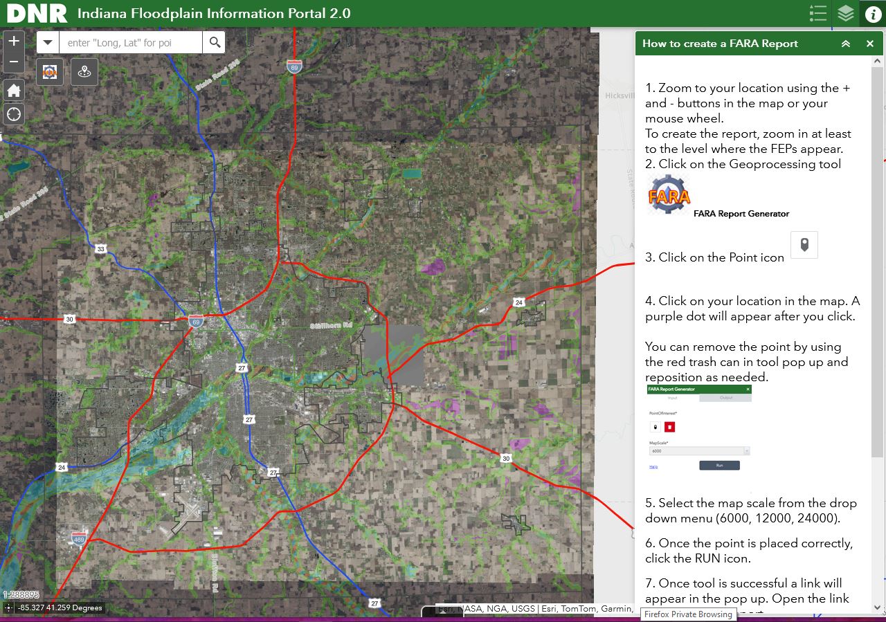
Knowing the floodplains in your area is crucial for flood preparedness. Floodplains are flat areas near water bodies prone to flooding. Consider elevating essential utilities like electrical panels and furnaces if you live in a floodplain. Always have a map with multiple evacuation routes and keep your preparedness kit ready. Stay informed about flood risks and plans. Remember, flood insurance policies take 30 days to become effective. The Indiana Department of Natural Resources Has a Floodplain Information Portal that includes both state and federal information. You can view that at Indiana Floodplain Information Portal. #FloodSafety#Preparedness
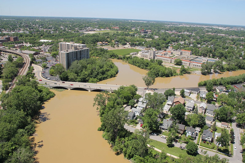
John McGauley photograph River Confluence taken June 3, 2013 posted on flickr An aerial view of the confluence of the St. Mary's, St. Joseph and Maume rivers in downtown Fort Wayne, Indiana.
Citizen River from Lynchpin Creative on Vimeo Filmed on location in Fort Wayne, Indiana on the St. Joseph River between Spy Run Avenue and Northside Drive.
Sponsored by Young Leaders of Northeast Indiana, Lincoln Financial Group. Original music by Alec Johnson.
A Watershed Mentality a WFWA TV39 PBS Fort Wayne Special | 27m 5s | Video has closed captioning. The Maumee River is the single largest tributary and watershed in the Great Lakes and deposits millions of cubic yards of sediment into Lake Erie yearly. Aired: 02/04/09 Rating: NR. DVD at the Allen County Public Library.
This video shows a modern look at how it would be possible to travel by river from Fort Wayne to the Gulf of Mexico.
Fort Wayne to Gulf of Mexico via river May 2, 2023 Scharpy1 on YouTube.
My first attempt at Google Earth tour recording. Wondered if it would be possible to float all the way to the Gulf of Mexico from close to home. Yes, it would. Start at Little River, 900 feet west of Ardmore Avenue next to Hardrock Road. Here's the kicker...go 1600 feet east of that point to float to the Atlantic Ocean via Fairfield Ditch, St. Marys River, Maumee River, Lake Erie, Niagra River, Lake Ontario, St. Lawrence River, Atlantic Ocean. Hence Fort Wayne's nickname: The Summit City, the high point of the Wabash and Erie Canal.
If a chemical spill were to happen on the St. Joseph River, City Utilities would take proper action while working with the U.S. Department of Homeland Security, the Indiana Department of Environmental Health and the Allen County Department of Health.
City Utilities said the delivery of safe, abundant, high-quality water to customers is an ongoing priority.
“To that end, Three Rivers Filtration Plant conducts more than 50,000 tests daily in our lab and through our automation processes,” the statement said. “Our water testing occurs every minute of every day.”
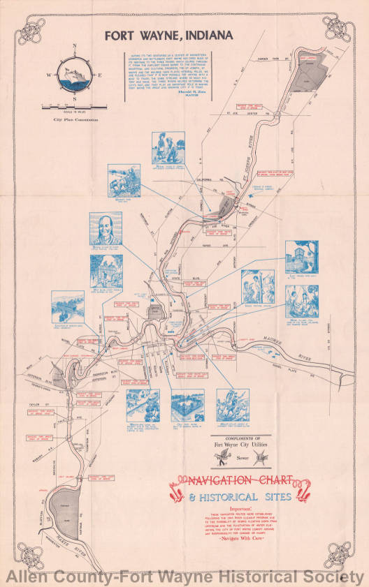
Reproduced above is a plan of a civic center for Fort Wayne made by Robert B. Hanna, Consultant to the City Plan Commission, assisted by LeRoy Bradley, a local architect. As described by Mr. Hanna in an article in today's News-Sentinel, the principal existing feature of the plan is the new Filtration Plant; and its principal proposed features are these: A group of five public buildings at the end of East Berry Street, to be terminated at Lafayette Street; relocating the East end of Main Street, bringing it in line with the bridge at the confluence; bridge at Lafayette Street — Spy Run Avenue; re-arranging street car lines, running them straight with these bridges; fourfold arch memorial spanning street intersection that would displace Old Fort Park; municipal pier and boat house; park areas; large fountain; statutes of Washington, Wayne and Little Turtle; beautified river banks; and a system of riverside drives about the confluence that could be extended up along the St. Joseph and St. Mary's rivers to towns above and down along the Maumee to Toledo.
Glorious Gate In that famous debate between General Anthony Wayne and Chief Little Turtle at conference which terminated in the Greenville Treaty of Peace. Little Turtle's main contention was for a large tract of aand about this confluence and in his eloquent speech he referred to this location as That Glorous Gate through which all the worlds of our chiefs have had to pass from the north to the south and from the east to the west.
Anthony WayneWayne's victorious campaign was the most noteworthy ever carried on against them (the Indians of the Northwest) for it brought the first lasting peace on the border and put an end to the bloody turmoil of forty years fighting. It was one of the most striking and weighty feats in the winning ofthe West - Theodore Roosevelt.
Railroad Consolidation - If the N.Y.C & St. L. railroad tracks should be abandoned, and their trains be routed through Fort Wayne over the Pennsylvania and Wabash tracks. Then a Riverside Drive should displace this R.R. right-of-way and this plan be revised accordingly
Riverfront Fort Wayne is the name for development of the 3 rivers in downtown Fort Wayne started in 2015 with a conceptual plan drawn up and shared with the community. Read more on their History page and follow on Facebook.
There Are Rivers by Dale Enochs posted September 11, 2021 by Fort Wayne Museum of Art on YouTube 100 Years ago, the Fort Wayne Museum of Art organized into a professional organization after starting with art classes in the homes of the West Central neighborhood in 1888. That organization - the Fort Wayne Museum of Art and School - graduated dozens of artists that, today, are still part of our vibrant arts community.
Dale Enochs is one of those artists, a Fort Wayne native and graduate of the Fort Wayne Art School. He's gone on to create dozens of public sculptures around the state, but this is his first in Fort Wayne.
The sculpture is called "There Are Rivers", and it pays homage to the 3 rivers that converge in Fort Wayne and their role in the development of the land and community.
Marti Schmuck Smith asked if I might have images of the old iron Spy Run Bridge that was replaced with a new concrete one in 1958. Here's a few. [See 1913 Flood page]
I know an aerial of this has been posted before, but its such a great moment in time shot that it bares repeating as part of this Spy Run Bridge post.
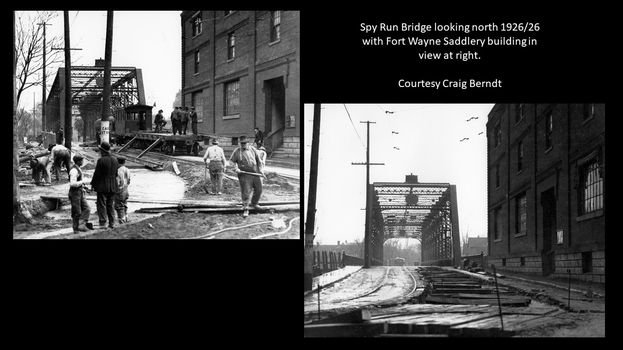
Here's a couple shots taken in 1925-26 looking north across the Spy Run Bridge. These rare images are courtesy of train/interurban historian, and pal, Craig Berndt.
2015/08/11: On the rivers in downtown Fort Wayne Indiana by AroundFortWayne posted July 5, 2016 on YouTube
On the St. Joseph, St. Marys and Maumee Rivers in downtown Fort Wayne Indiana and as far as one can navigate.
Special thanks to Josh Harper for providing the AroundFortWayne time lapse camera, Captain Dan Wire for the pontoon ride and Alec Johnson - smartalecproductions.com - for the soundtrack
Many people think rivers flow from north to south, but Fort Wayne’s rivers are great examples of rivers that don’t flow in the direction you think they might.
Fort Wayne sits on what is known as the St. Lawrence continental divide that separates the Great Lakes Basin from the Gulf of Mexico watershed.
Although the land around Fort Wayne is flat, the city is on a small ridge that resulted from receding glaciers that covered the area in the Ice Age.
The St. Joseph River begins in Hillsdale County, Michigan. It flows southeast into Ohio where it turns and flows southwest to Fort Wayne.
The St. Marys River begins near Celina, Ohio. It flows northwest into Fort Wayne where it meets the St. Joseph River near Headwaters Park.
The two rivers combine to form the Maumee River. It flows in a northeasterly direction and ends at Toledo where it dumps into Lake Erie.
What happened to the apostrophe in the St. Marys River? According ot the U.S. Board of Geographic Names, it is correct to write St. Marys River and incorrect to write St. Mary’s River. This is because the river is named St. Marys and isn’t a river that belongs to St. Mary.
Fort Wayne: riverfront heritage and historic building reuse posted August 4, 2018 on Archives of Hoosier History Live podcast on Saturdays, noon to 1 p.m. ET on WICR 88.7 FM. The introduction begins with The state's second-largest city is located at the confluence of three waterways: the St. Joseph, St. Mary's and Maumee rivers. Against the backdrop of a vibrant revival of the downtown riverfront in Fort Wayne, we will explore the impact of the rivers on the city as well as current initiatives to reuse historic riverfront buildings. A significant aspect of the city's river history involves the Wabash & Erie Canal that began operating in 1835 and came right through Fort Wayne. ... Nelson will be joined by two studio guests who will serve as our guides through Fort Wayne's riverfront history and the new ways it's being showcased: Allen County historian Tom Castaldi, who writes a history column for Fort Wayne Monthly magazine and hosts "On the Heritage Trail" segments about local history for WBOI-FM Radio. And Fort Wayne historian Randy Harter, the owner of Fort Wayne Food Tours, which offers downtown walking tours exploring the city's history, architecture and food heritage. Randy also is the author of several books, including Legendary Locals of Fort Wayne (Arcadia Publishing, 2015) - fellow guest Tom Castaldi is among those profiled in it - and Fort Wayne Through Time, which will be published this fall.
Little River Wetlands Project in the watershed of the Little River, a major tributary of the Wabash River on the west side of city, bald eagles frequent area, since 1990 1,000 restored acres of marsh and prairie of former 25,000 acre Great Marsh.Little River Valley has videos and lots of information at the Little River Wetland Project..
The U.S. Geological Survey (USGS) National Water Information System and the National Water Dashboard got a new interactive interface! This online tool is always our first stop for checking the river stage while planning to go out and do river research, or to obtain historical stage data. Take a look and for more information, join the public lecture on September 23 to hear from the USGS how to navigate through it!
USGS National Water Dashboard for Indiana shows real-time water data collected at U.S. Geological Survey (USGS) observation stations in context with weather-related data from other public sources.
USGS Streamer - Explore Americaa's larger streats as you trace upstream to their source or downstream to where they empty. Learn more about your stream traces and the places they pass through in brief or detailed reports. See weather radar and near real-time streamflow conditions.
MamaJo - see Water Filtration section. It’s part of an 18-year, $240 million effort to reduce the number of combined sewer overflows into Fort Wayne’s three rivers – the St. Joseph, St. Marys and the Maumee – from an average of 76 overflows per year to four. The St. Joseph is the first watershed that will reach compliance with the consent decree, Wirtz [Matthew Wirtz, City Utilities deputy director] said. Overflows occur when high water volumes, such as what might occur during heavy rainfall, back up the city’s combined sewer system, causing it to alleviate the pressure by discharging into the rivers. The St. Joseph River typically overflows 12 to 15 times a year, causing sewers to dump 9 million gallons of wastewater into the river. Through some earlier sewer separation projects, City Utilities has been able to decrease that amount to about 5 million gallons per year. "All those overflows (on the St. Joseph River) will be reduced to one or less in a typical year," Wirtz said. He said this portion of the project will be completed four years ahead of schedule and is expected to come in significantly under budget. Once the project is complete, it’s expected to discharge only about half a million gallons into the river in a typical year – a 97 percent decrease from the current overflow levels. Copied from Watershed year for St. Joe River Will achieve compliance with 2008 decree next year by Dave Gong published December 25, 2014 in The Journal Gazette newspaper.
Watersheds - Art Meets Science, These Beautiful Maps Capture the Rivers That Pulse Through Our World Cartographer Robert Szucs creates colorful maps of the watersheds that creep across states, countries, continents and the globe by Anna White March 25, 2019 in Smithsonian Magazine and shared October 4, 2022 on their Facebook page.
The Indians, perhaps for centuries, had been accustomed to look to the streams here for much of their food in the form of fish, so abundant were they from Lake Erie to this point, and for some distance up the St. Mary's and St. Joseph. During seasons of freshets, in great quantities, and some of them very large, they would find their way up the Maumee from the lake, and when the high water subsided, they were often so numerous, that it was difficult to ride a horse or drive a team across the streams here without the animals or the wheels of the vehicles running over some of the finny tribe ; and some years ago, a company from Cincinnati began, and for several years carried on, the manufacture of oil from the fish caught here. Many boys and Indians made very good wages by catching the fish for the company. The Indians had always been of the belief that the Great Spirit had thus filled these streams with fish for tlieir special benefit, and when, a few years subsequent to the period in question, a dam was built near the mouth ot the Maumee, at the Lake, and the fish prevented from getting into this stream, as their number gradually diminished, and the company compelled to cease its operations thereby, the Indians expressed great displeasure, and considered it a direct encroachment upon their rights, and the designs of the Great Spirit. from page 295 titled Great Quantities of Fish in the Maumee in the book History of Allen County, Indiana, Publication date 1880, Publisher Kingman Brothers on Archive.org.
Maumee River (City Plan Commission 1963), by City Plan Commission (Fort Wayne, Ind.), August 1963, Description: There are 17 maps one of which is a Key. Then there are two maps per each section of the river. One map describes landownership along the river, types of river debris and/or storm drains and the like, and historical sites. The other corresponding section map describes the river level at designated measuring stations.
Few have probably heard of the Bullerman Ditch, which has its origins near the corner of Lahmeyer and Stellhorn roads in northeast Fort Wayne. From there, it winds south for about 3 miles through urbanized development and a bit of agricultural land before it drains into the Maumee River at North River Road. "As tributaries go," said Matt Jones, water resource education specialist for the Allen County Partnership for Water Quality, "it may seem like it’s just a drop in the bucket, but indeed, it runs through the most intensely landscaped countryside as it makes its way to the Maumee." With a conference on an Upper Maumee Watershed environmental implementation plan scheduled for Jan. 24, Save Maumee Grassroots Organization’s founder Abigail King has initiated a campaign to highlight the importance of the Bullerman Ditch. Copied from a longer article Save Maumee campaigns for clean ditch by Jamie Duffy published March 16, 2016 in The Journal Gazette newspaper.
Highlights of the Maumee River Valley Did you know… The Maumee River is the largest in the entire Great Lakes System, unique geography of the Maumee watershed is a remnant of glaciers and the slowly falling water levels of prehistoric Lake Erie, served as a link between the Mississippi River system and the Great Lakes for humans for over 10,000 years, Britain and France vied for dominance in trade with Native American communities, and it was a major theater during the era between the French and Indian War and the War of 1812, France built two forts in the valley–Fort St. Phillipe des Miamis and Fort Miamis– near what is now downtown Fort Wayne, between 1700 and 1750 - read more from Maumee Valley Heritage Corridor.
St Marys and Maumee at Indiana Department of Natural Resources. The St. Marys River and Maumee River Watershed is located in northeastern Indiana, draining approximately 376 square miles in Adams and Allen counties. Major streams included in the Total Maximum Daily Load (TMDL) report are St. Marys River, Maumee River, Habegger Ditch, Gates Ditch, Blue Creek, Yellow Creek, Martz Ditch, Borum Run, Holthouse Ditch, Kohne Ditch, Gerke Ditch, and Nickelsen Creek, Trier Ditch, Bullerman Ditch, Gar Creek, Botern Ditch, Black Creek, Ham Interceptor Ditch and other tributaries.
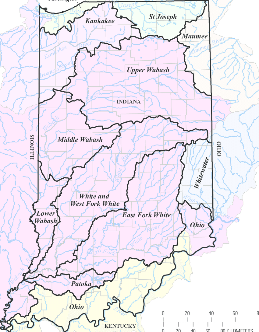
Did you know that most of Allen County is a part of the Maumee River Watershed? A watershed is an area of land that drains water into a particular water
Fort Wayne, IN: Canal Feeder Dam and Robison Amusement Park, 1896-1919 posted February 5, 2020 on Towns and Nature blog included a September 2020 Facebook post that stated: Dam was in middle of “S” curve (see an arial view) on St Joe River by former site of Swift-Goshorn mill at Paradise Lagoon, just downstream from feeder canal (Summit Point). The earthen dikes are on both sides of the river, if you know where to look. This area is undeveloped floodplain, just east of Northpointe Woods clubhouse. I believe some of that is now private property, but it used to belong to City of Ft Wayne, before that it was the old Kroemer farm. I used to go back there in the seventies. Interesting thing is that area was meant to be the originally proposed site of the Fort’s backup water supply. They had planned to dam the river again in the twenties/thirties, but instead opted for the Cedarville Reservoir further upstream.
Our own Megan Butler filled up a bottle of water from the St. Marys River today to see how clear it really is. We will be spending the summer educating you on how our rivers are natural, where they get their appearance from, and how you can enjoy them! Our new website will debut soon with resources for you to enjoy.
It's #waybackwednesday! Take a look at this aerial view of the St. Mary's River and downtown Fort Wayne in 1924. This image comes from the Bert J. Griswold Collection in our Community Album. [showing what is now Headwaters Park at the confluence of the Three Rivers]
According to the United States Board on Geographic Names, it is correct to write St. Marys River, and incorrect to write St. Mary’s River. In all communications, Riverfront Fort Wayne will use St. Marys River, and will advocate for the elimination of St. Mary’s River in all other signage and communication. Copied from What happened to the apostrophe in the St. Marys River? posted 03/13/2017 on Riverfront Fort Wayne blog.
FUN FACT: Did you know that in 1910, the St. Marys River was officially named by the United States Geographic Board?
According to the Geographic Names Information System of the USGS (https://on.doi.gov/2qocPZz), while it was recognized that a variant name was "St. Mary's," the official name does not include the apostrophe.
Many people think rivers flow from north to south, but Fort Wayne’s rivers are great examples of rivers that don’t flow in the direction you think they might.
Fort Wayne sits on what is known as the St. Lawrence continental divide that separates the Great Lakes Basin from the Gulf of Mexico watershed. 🌊
Although the land around Fort Wayne is flat, the city is on a small ridge that resulted from receding glaciers that covered the area in the Ice Age. 🧊
The St. Joseph River begins in Hillsdale County, Michigan. It flows southeast into Ohio where it turns and flows southwest to Fort Wayne. 💦
The St. Marys River begins near Celina, Ohio. It flows northwest into Fort Wayne where it meets the St. Joseph River near Headwaters Park. 🦦
The two rivers combine to form the Maumee River. It flows in a northeasterly direction and ends at Toledo where it dumps into Lake Erie. 🌊
? What happened to the apostrophe in the St. Marys River?
According to the U.S. Board of Geographic Names, it is correct to write St. Marys River and incorrect to write St. Mary’s River. This is because the river is named St. Marys and isn’t a river that belongs to St. Mary. 🦦 💦
St Marys and Maumee at Indiana Department of Natural Resources. The St. Marys River and Maumee River Watershed is located in northeastern Indiana, draining approximately 376 square miles in Adams and Allen counties. Major streams included in the Total Maximum Daily Load (TMDL) report are St. Marys River, Maumee River, Habegger Ditch, Gates Ditch, Blue Creek, Yellow Creek, Martz Ditch, Borum Run, Holthouse Ditch, Kohne Ditch, Gerke Ditch, and Nickelsen Creek, Trier Ditch, Bullerman Ditch, Gar Creek, Botern Ditch, Black Creek, Ham Interceptor Ditch and other tributaries.
It's #waybackwednesday! Take a look at this moonlight view of the St. Mary's River in Fort Wayne. This image is courtesy of the Harter Postcard Collection in our Community Album.
“This will allow aquatic life to migrate downstream instead of staying in one area, it will improve the ecological balance of the river and it will also protect the banks,” Suarez said.
The Lawton Park Spy Run Creek Dam is near the physical start of Spy Run Creek– however, the dam has long outlived its intended purpose. “The dam was put in when what is now Science Central was the electric plant,” Suarez said. “Nearly 100 years ago it was used to cool the turbines that were used to create electricity, and they wanted to have water backups so they would have a pool of water to cool those.” Copied from Fort Wayne dam may be demolished; city cites ecological factors
2017/03/23: Dan Wire talks about the new Canal Boat by AroundFortWayne March 27, 2017 on YouTube Dan Wire, Executive Director of the Tri-State Watershed Alliance, speaks with the media after the unveiling of the boat by the Friends of the Rivers. This is a new attraction for downtown Fort Wayne and will be plying the waters of the downtown areas of the three rivers - the St. Marys River, St. Joseph River and Maumee River.
SweetBreeze MediumSpeed by FortWayneParks October 26, 2022 on YouTube.
Fast-forward to the end of the season as Sweet Breeze is removed from the St. Marys river and prepped for storage.
Sweet Breeze Canal Boat Launch 2023 by FortWayneParks May 9, 2023 on YouTube.
The Sweet Breeze Canal Boat is back on the St. Marys River! Step aboard and learn more about the upcoming season of general and specialty tours at the Season Kickoff Open House on Friday, May 26, from 6:00 - 8:00 p.m. Tour schedule and reservations are available now at www.RideSweetBreeze.org.
Also May 9, 2023 post on Facebook.
USGS Prepared in Cooperation with the City of Fort Wayne, Indiana Flood-Inundation Maps for the St. Marys River at Fort Wayne, Indiana Prepared in Cooperation with the City of Fort Wayne, Indiana Flood-Inundation Maps for the St. Marys River at Fort Wayne, Indiana By Chad D. Menke, Moon H. Kim, and Kathleen K. Fowler Pamphlet to accompany Scientific Investigations Map 3205 U.S. Department of the Interior U.S. Geological Survey U.S. Department of the Interior KEN SALAZAR, Secretary U.S. Geological Survey Marcia K. McNutt, Director U.S. Geological Survey, Reston, Virginia: 2012.
Rivers On A Rampage - Recent Rains Cause Floods in all the Streams - St. Mary's and St. Joe Over Their Banks With Prospects for Record-Breaking Floods was the headline April 14, 1903 in the Fort Wayne News newspaper article April 14, 2014 discussion on the original Great Memories and History of Fort Wayne, Indiana page on Facebook.
Did you know Indiana has a flood insurance website where you can learn about flood risk, flood insurance, and mitigation activities? This site is joint project developed by the Indiana Department of Homeland Security, Indiana Department of Insurance and the Indiana Department of Natural Resources Division of Water. Check it out at IN.gov/floodinsurance.
Fort Wayne’s rivers continue to have high waters as flooding impacts the safety of those on the water. This type of danger, however, is something that Fort Wayne is used to.
PrimeTime Clean Drains
Season 2023 Episode 3126 | 26m 51s |
Video has closed captioning.
Guests: Irene Walters (Co-Chairwoman | Clean Drains Fort Wayne), Jennifer Lash (Program Manager | Fort Wayne City Utilities), & Alexandra Hall (Public Art Consultant & Artist). This area’s only in-depth, live, weekly news, analysis and cultural update forum, PrimeTime airs Fridays at 7:30pm. This program is hosted by PBS Fort Wayne’s President/General Manager Bruce Haines.
Aired: 07/28/23
CONTINUING COVERAGE - After taking you underground for the start of construction on the Deep Rock Tunnel, we get a look at the drill that did the work before it's disassembled.
Slowly, but surely, progress is being made on the drilling of Fort Wayne's Deep Rock Tunnel. It's the project that should reduce flooding and overflow into the city's rivers. WANE 15's Chris Darby WANE 15 and Taylor Williams WANE 15 gives us our first look inside the tunnel.
Today, Mayor Tom Henry joined Woodhurst neighborhood residents and City Utilities to break ground on construction of the final neighborhood pipe of the Deep Rock Tunnel project.
A long post but PLEASE be engaged and SHARE SHARE SHARE! Even if you don’t live in the Northside Neighborhood, this issue could affect the future of our rivers.
Dear Neighbors, this may very well be a moment in time when the actions of a few determine a dramatic change in the character of our Northside Neighborhood.
The Allen County Plan Commission recently passed the request for zoning change (from residential to commercial) and the preliminary site plan for the property at Spy Run Ext. and Parnell. This request for a party boat “headquarters,” while not officially in the Northside Neighborhood could have a big effect on the quiet, family-friendly area that we all love.
The board of the NNA has written letters, passed petitions, communicated with neighbors and city leaders, spoken at the plan commission hearing, etc. The next step in the process is for Fort Wayne City Council to vote on the recommendation to approve the zoning change and preliminary site plan. This is where we can put a stop to the plan. WE NEED YOU!
While our city council representative, Russ Jehl, has communicated his intention to support the desires of his constituency and vote, “no,” his is only one vote. PLEASE contact the other members of city council and ask the to also vote, “NO!” We’re including here a list of email addresses (you can cut and paste), but it will also be helpful for you to CALL!
We’re adding some of the points that are helpful in making our case that the location of this party-based business is BAD for the Northside Neighborhood.
We in the Northside Neighborhood LOVE our rivers. We ARE the “river neighborhood,” bordered on three sides by the rivers. We LOVE encouraging people to enjoy this naturally beautiful asset of our city! We LOVE riverfront development that ADDS to the quality of life here in the Northside. This development will DE
TRACT from those of us who live closest to the rivers.
Here are some points to make when contacting our city council members (all of them!). It’s also helpful to copy Mr. Jehl on your communications and thank him for supporting the Northside Neighborhood.
1) Increased traffic and overflow parking in the Northside Neighborhood.
2) Increased automobile traffic around the trail system in the Spy Run/Parnell area, disturbing and making unsafe its use by pedestrians and cyclists. Moving the trail to streetside and along the parking lot is not comparable nor an acceptable solution that is fair to the taxpayers and users of the trail system.
3) Increased noise from the large number of partyers on the river at once, disturbing and making unsafe the quiet riparian environment currently enjoyed by kayakers and others paddlers.
4) Concerns about increased incidences of public intoxication and driving under the influence in the neighborhood.
5) Increased traffic in an already congested area.
(And the following statements are regarding the Fort Wayne Allen County Comprehensive Plan, ways in which the proposal contradicts the plan which was adopted by the city as a guiding document.)
6) This proposal is not compatible with surrounding development which is predominately Residential Zoning and Residential Land Use.
7) This proposal will negatively impact nearby property values by removing natural elements that draw homeowners. It will also negatively impact property values by situating an adult outdoor business near residential neighborhoods. It will be injurious to the morals of the families living in the surrounding homes.
This proposal will be injurious to public safety and general welfare by removing the beneficial features of the existing property, which are many.
The Maumee Torrent, also known as the Maumee Megaflood, was a catastrophic draining of Lake Maumee, the ancestor of present-day Lake Erie, that occurred approximately 14,000[1] to 17,000 years ago[2] during the late Wisconsin glaciation. It happened when the waters of Lake Maumee, possibly in response to an advance of the ice front at the eastern end of the lake, overtopped a "sag" or low spot in the Fort Wayne Moraine, which was a deposit of glacial debris that acted as a natural dam at the site of present-day Fort Wayne, Indiana. This unleashed a massive flow of water that scoured a one- to two-mile-wide outlet running southwest to the Wabash River known as the "Wabash-Erie Channel", which probably followed the course of earlier, less massive drainage. The channel, now a small stream called the Little River, is the largest topographical feature in Allen County, Indiana. As much as 30 feet of fine sand, silt and organic sediments were deposited in the channel before drainage reversed and was captured by the present-day Maumee River. U.S. Route 24 between Fort Wayne and Huntington follows the channel.[3]
Approximately 14,000 years before present, Lake Maumee overtopped the Fort Wayne Moraine. [1] The flood removed all earlier sediment and deepened the valley bottom by 20 feet (6.1 m).[1] Lake Maumee had reached 800 feet (240 m) above sea level when the lake poured through a sag in the Fort Wayne Moraine into the ancestral Little River and then the Wabash River. There is some evidence that the final rise in lake level that caused it to overtop the moraine was caused by a minor re-advance of the glacier further east in the basin.[1] The soft till of the moraine was quickly eroded by the volume of water in the lake, releasing a massive volume of water. A second outlet opened at Six-Mile Creek into the St. Marys River and into the Little River Valley. The earlier sediments were removed in bulk, leaving only the Sand Point and a few gravel terraces on the valley walls.[1] The flood scoured the length of the Wabash River. The limestone bedrock under the Little River Valley near Huntington created a sill, limiting the depth to which the Torrent and the future river could erode. The well-developed beach ridges in Ohio and eastern Allen County show a series of lower lake levels.[1]Copied January 2, 2024 from Maumee Torrent on Wikipedia, The Free Encyclopedia.


 What happened to the apostrophe in the St. Marys River?
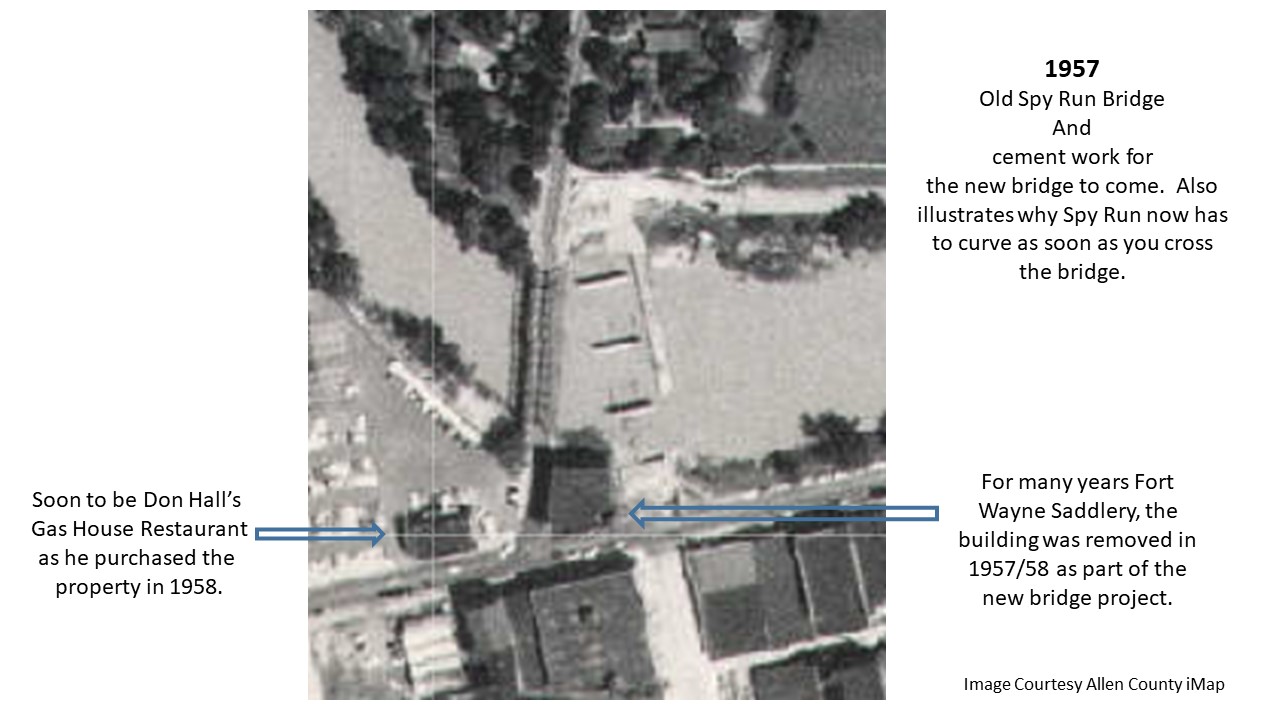


Sharing our appearance on PBS Fort Wayne’s Prime Time. Please watch, learn, and help us keep our rivers clean.
🩵